U.S. Route 10 in Wisconsin
U.S. Highway 10 (US 10) in Wisconsin runs east–west across the central part of the state. It runs from the Prescott Drawbridge over the St. Croix River at Prescott east to the dock in Manitowoc where the SS Badger crosses Lake Michigan to Ludington, Michigan. The highway is also designated as the Vietnam War Veterans Memorial Highway for its entire length.[2]
| |||||||
|---|---|---|---|---|---|---|---|
| Vietnam War Veterans Memorial Highway | |||||||

US-10 highlighted in red | |||||||
| Route information | |||||||
| Maintained by WisDOT | |||||||
| Length | 294.01 mi[1] (473.16 km) | ||||||
| Existed | 1926–present | ||||||
| Major junctions | |||||||
| West end | |||||||
| East end | |||||||
| Location | |||||||
| Counties | Pierce, Pepin, Buffalo, Trempealeau, Jackson, Eau Claire, Clark, Wood, Portage, Waupaca, Winnebago, Calumet, Manitowoc | ||||||
| Highway system | |||||||
| |||||||

Route description
US 10 enters the state and Pierce County from Minnesota at Prescott and immediately joins with WIS 35 north. WIS 35 turns north one mile (1.6 km) northeast at WIS 29 while US 10 continues east and passes through Ellsworth at the junctions with WIS 65 and US 63 The highway turns southeast and passes through Ono and Plum City.[3] US 10 then enters Pepin County and junctions with WIS 25 and WIS 85 at Durand[4] US 10 briefly enters Buffalo County and passes through Mondovi at the junction with WIS 37.[5] In northern Trempealeau County, the highway crosses WIS 93 at Eleva, passes through Strum, and junctions with US 53 and I-94 in Osseo.[6] The route then enters Jackson County where it joins US 12 and WIS 27.[7] US 12 and WIS 27 split to the south at the Clark County line while US 10 continues east to Neillsville and crosses WIS 73 there.[8] The highway then meanders northeast into Wood County, intersecting with WIS 80. US 10 becomes an expressway at this intersection, and continues as an expressway until the Wood–Portage county line. The highway then passes south of Marshfield, meeting WIS 13 one mile (1.6 km) south of Marshfield at a diamond interchange. US 10 then passes south of Auburndale and enters Portage County near Milladore.[9]
US 10 enters Portage County as a freeway, and meets WIS 34 and WIS 13 south two miles (3.2 km) west of Junction City. WIS 34 splits to the north two miles (3.2 km) east of Junction City while US 10 turns east and bypasses Stevens Point. The highway then meets I-39/US 51 north of the city and runs concurrently with I-39/US 51 for about seven miles (11 km) before exiting to the east of Stevens Point. At this point, US 10 becomes a multilane surface road for about six miles, then becomes an expressway and heads southeast, passing through Amherst and crossing into Waupaca County.[10] US 10 bypasses the city of Waupaca to the south and junctions with WIS 22, WIS 54 and meets WIS 49 south. US 10 and WIS 49 turn eastward to Weyauwega then head south to Fremont where WIS 49 turns south and US 10 becomes a freeway at the junction with WIS 110.[11] US 10 collects US 45 south in northwest Winnebago County for a three-mile (4.8 km) southeast trek before US 45 splits to the south and US 10 turns east to rendezvous with WIS 441 at the junction with I-41/US 41 in Neenah. US 10 turns south off the WIS 441 freeway south of Appleton and turns east into Calumet County.[12]
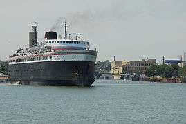
As a multilane urban arterial, US 10 collects WIS 114 for four miles (6.4 km) before the latter splits southward two miles (3.2 km) before US 10 junctions with WIS 55. The highway then crosses WIS 32 and WIS 57 at Forest Junction and turns southeast to pass through Brillion and into Manitowoc County.[13] The highway passes through Reedsville and Whitelaw before turning south onto I-43 for three miles (4.8 km) and turning east off the Interstate to head along WIS 42 into the north side of Manitowoc. US 10 then turns south into downtown where it continues into Michigan via the SS Badger carferry to Ludington.[14] The Badger only operates on a seasonal basis from May to October.[15]
History
Prior to 1926, what is now US 10 was State Trunk Highway 18. However, Highway 18 initially (in 1917) only ran from Humbird, near where US 10 and U.S. Highway 12 (then State Trunk Highway 12) cross, east to Manitowoc. State Trunk Highway 34 ran from Prescott to Highway 37 in Mondovi. The route between Mondovi and Humbird was not numbered until the early 1920s, when Highway 18 was extended west from Humbird past Mondovi to Prescott, eliminating Highway 34.[16]
When US 10 was designated in late 1926, it ran along U.S. Highway 12 from Minnesota east to Humbird, splitting there to run to Manitowoc.[17] The piece of former Highway 18 west of Humbird became Highway 34, as the number 18 conflicted with U.S. Highway 18. In 1934, Highway 34 disappeared again, as US 10 was separated from the US 12 concurrency to run along it.[18]
At their spring meeting in 2015, the American Association of State Highway and Transportation Officials committee extended US 10 to include the route of the SS Badger between Ludington and Manitowoc.[19]
Major intersections
| County | Location | mi[1] | km | Exit[20] | Destinations | Notes |
|---|---|---|---|---|---|---|
| St. Croix River | 0.000 | 0.000 | Continuation into Minnesota | |||
| Prescott Drawbridge; Wisconsin–Minnesota line | ||||||
| Pierce | Prescott | 0.09 | 0.14 | Eastern end of GRR concurrency; western end of WIS 35 concurrency | ||
| 1.32 | 2.12 | Western terminus of WIS 29; eastern end of WIS 35 concurrency | ||||
| Hager City | 9.12 | 14.68 | ||||
| Trimbelle | 12.16 | 19.57 | ||||
| 13.71 | 22.06 | |||||
| 15.56 | 25.04 | Western end of US 63 concurrency | ||||
| Ellsworth | 17.16 | 27.62 | ||||
| 18.84 | 30.32 | Eastern end of US 63 concurrency | ||||
| Bay City | 22.87 | 36.81 | ||||
| Ono | 33.51 | 53.93 | ||||
| Plum City | 37.24 | 59.93 | ||||
| Pepin | Arkansaw | 47.19 | 75.94 | Western end of WIS 25 concurrency | ||
| Durand | 48.16 | 77.51 | Eastern end of WIS 25 concurrency | |||
| 49.66 | 79.92 | |||||
| Buffalo | Mondovi | 64.82 | 104.32 | Western end of WIS 37 concurrency | ||
| 65.54 | 105.48 | Eastern end of WIS 37 concurrency | ||||
| Trempealeau | Eleva | 74.89 | 120.52 | |||
| Osseo | 85.18 | 137.08 | Western end of US 53 concurrency | |||
| 87.60 | 140.98 | Eastern end of concurrency | ||||
| 88.52 | 142.46 | I-94 exit 88 | ||||
| Jackson | Fairchild | 101.39 | 163.17 | Western end of US 12 concurrency | ||
| 103.28 | 166.21 | Eastern end of US 12 concurrency | ||||
| Clark | Neillsville | 120.13 | 193.33 | |||
| Granton | 127.41 | 205.05 | Western end of CTH-K concurrency | |||
| 128.54 | 206.87 | Eastern end of CTH-K concurrency | ||||
| Wood | Marshfield–Cameron town line | 142.99 | 230.12 | Roundabout | ||
| Marshfield | 146.95 | 236.49 | 187 | Interchange; western end of WIS 13 concurrency | ||
| Hewitt | 148.90 | 239.63 | ||||
| Auburndale | 152.41 | 245.28 | CTH-P is former WIS 186 north | |||
| Blenker | 155.72 | 250.61 | ||||
| Milladore | 160.72 | 258.65 | ||||
| Portage | Junction City | 163.62 | 263.32 | 204 | West end of freeway; western end of WIS 34 concurrency; eastern end of WIS 13 concurrency | |
| 168.04 | 270.43 | 208 | Eastern end of WIS 34 concurrency; CTH-P is former US 10 | |||
| Hull | 172.90 | 278.26 | 213 | Left entrance eastbound, left exits; western end of I-39/US 51 concurrency; no exit number westbound; I-39 exit 165 | ||
| 175.69 | 282.75 | 163 | Casimir Road | Exit numbers follow I-39 | ||
| Stevens Point | 177.56 | 285.76 | 161 | |||
| 178.06 | 286.56 | 159 | Northern end of WIS 66 concurrency | |||
| 179.94 | 289.59 | East end of freeway section; eastern end of I-39/US 51 concurrency; southern end of WI 66 concurrency; I-39 exit 158 | ||||
| Stockton | 183.95 | 296.04 | 230 | Interchange | ||
| Custer | 188.50 | 303.36 | Western end of CTH-K concurrency | |||
| Stockton | 191.20 | 307.71 | ||||
| 191.90 | 308.83 | Eastern end of CTH-K concurrency | ||||
| Town of Amherst | 190.94 | 307.29 | 237 | Lake Drive – Amherst Junction | West end of freeway; eastbound exit and westbound entrance | |
| Amherst | 192.51 | 309.81 | 238 | Western end of CTH-B concurrency | ||
| 194.51 | 313.03 | 240 | Eastern end of CTH-B concurrency | |||
| Waupaca | Sheridan | 200.89 | 323.30 | |||
| Waupaca | 204.69 | 329.42 | 250 | West end of freeway; western end of WIS 49/WIS 54 concurrency | ||
| 205.97 | 331.48 | 252 | Western end of WIS 22 concurrency | |||
| 207.38 | 333.75 | 253 | Churchill Street | |||
| 208.66 | 335.81 | 254 | East end of freeway; eastern end of WIS 22/WIS 54 concurrency | |||
| Weyauwega | 213.95 | 344.32 | 260A | Interchange; western end of WIS 110 concurrency | ||
| 214.92 | 345.88 | 260B | Interchange; westbound exit and eastbound entrance | |||
| Fremont | 218.73 | 352.01 | 264 | West end of freeway; eastern end of WIS 49/WIS 110 concurrency | ||
| 221.77 | 356.90 | 267 | Western terminus of WIS 96; southern terminus of WIS 110 | |||
| Winnebago | Winchester | 228.02 | 366.96 | 273 | Western end of US 45 concurrency | |
| 230.59 | 371.10 | 276 | Eastern end of US 45 concurrency | |||
| Fox Crossing | 238.10 | 383.18 | 284 | Eastbound also signed To US 41 north | ||
| 240.54 | 387.11 | 286 | ||||
| 241.68 | 388.95 | 287A-B | Westbound exits split into exits 287A (north) and 287B (south); western end of WIS 441 concurrency; I-41 exits 134A-B | |||
| Menasha | 242.64 | 390.49 | 289A | |||
| 243.75 | 392.28 | 289B | ||||
| 244.91 | 394.14 | 290 | ||||
| Calumet | Waverly Beach | 245.91 | 395.75 | East end of freeway section; eastern end of WIS 441 concurrency; WIS 441 exit 291 | ||
| 247.39 | 398.14 | Western end of WIS 114 concurrency | ||||
| Highland Beach | 250.88 | 403.75 | Eastern end of WIS 114 concurrency | |||
| 255.50 | 411.19 | |||||
| Forest Junction | 261.90 | 421.49 | ||||
| Brillion | 267.23 | 430.06 | ||||
| Manitowoc | Reedsville | 272.53 | 438.59 | |||
| Cato | 277.89 | 447.22 | ||||
| Whitelaw | 279.91 | 450.47 | ||||
| Manitowoc Rapids | 284.70 | 458.18 | Western end of I-43 concurrency; I-43 exit 154; western terminus of WIS 310 | |||
| 287.75 | 463.09 | Eastern end of I-43 concurrency; western end of WIS 42 concurrency; I-43 exit 152 | ||||
| Manitowoc River | Bridge | |||||
| Manitowoc | 291.40 | 468.96 | Eastern end of WI 42 concurrency; western end of Bus. WIS 42/LMCT concurrency | |||
| 292.86 | 471.31 | Eastern end of Bus. WIS 42/LMCT concurrency | ||||
| Lake Michigan | 294.01 | 473.16 | Carferry to Ludington, Michigan, connection to US 10 in Michigan | |||
1.000 mi = 1.609 km; 1.000 km = 0.621 mi
| ||||||
See also
- U.S. Route 110, a short and short-lived spur from Fremont to Oshkosh
References
- DeLorme (2007). Street Atlas USA 2007 (Map). DeLorme.
- "Commemorative highways and bridges". Wisconsin Department of Transportation. Retrieved July 4, 2018.
- Wisconsin Department of Transportation. Pierce County (PDF) (Map). Madison: Wisconsin Department of Transportation. Archived from the original (PDF) on May 16, 2008. Retrieved December 29, 2007.
- Wisconsin Department of Transportation. Pepin County (PDF) (Map). Madison: Wisconsin Department of Transportation. Archived from the original (PDF) on May 16, 2008. Retrieved December 29, 2007.
- Wisconsin Department of Transportation. Buffalo County (PDF) (Map). Madison: Wisconsin Department of Transportation. Archived from the original (PDF) on May 16, 2008. Retrieved December 29, 2007.
- Wisconsin Department of Transportation. Trempealeau County (PDF) (Map). Madison: Wisconsin Department of Transportation. Archived from the original (PDF) on May 16, 2008. Retrieved December 29, 2007.
- Wisconsin Department of Transportation. Jackson County (PDF) (Map). Madison: Wisconsin Department of Transportation. Archived from the original (PDF) on May 16, 2008. Retrieved December 29, 2007.
- Wisconsin Department of Transportation. Clark County (PDF) (Map). Madison: Wisconsin Department of Transportation. Archived from the original (PDF) on May 16, 2008. Retrieved December 29, 2007.
- Wisconsin Department of Transportation. Wood County (PDF) (Map). Madison: Wisconsin Department of Transportation. Archived from the original (PDF) on May 16, 2008. Retrieved December 29, 2007.
- Wisconsin Department of Transportation. Portage County (PDF) (Map). Madison: Wisconsin Department of Transportation. Archived from the original (PDF) on May 16, 2008. Retrieved December 29, 2007.
- Wisconsin Department of Transportation. Waupaca County (PDF) (Map). Madison: Wisconsin Department of Transportation. Archived from the original (PDF) on May 11, 2008. Retrieved December 29, 2007.
- Wisconsin Department of Transportation. Winnebago County (PDF) (Map). Madison: Wisconsin Department of Transportation. Archived from the original (PDF) on May 16, 2008. Retrieved December 29, 2007.
- Wisconsin Department of Transportation. Calumet County (PDF) (Map). Madison: Wisconsin Department of Transportation. Archived from the original (PDF) on May 16, 2008. Retrieved December 29, 2007.
- Wisconsin Department of Transportation. Manitowoc County (PDF) (Map). Madison: Wisconsin Department of Transportation. Retrieved December 29, 2007.
- Lake Michigan Carferry. "SS Badger History". Lake Michigan Carferry. Archived from the original on September 6, 2015. Retrieved September 28, 2014.
- Bessert, Christopher J. (February 6, 2007). "Highways 30-39". Wisconsin Highways. Self-published. Retrieved March 20, 2007.
- Bureau of Public Roads & American Association of State Highway Officials (November 11, 1926). United States System of Highways Adopted for Uniform Marking by the American Association of State Highway Officials (Map). 1:7,000,000. Washington, DC: United States Geological Survey. OCLC 32889555. Retrieved November 7, 2013 – via University of North Texas Libraries.
- Bessert, Christopher J. (February 6, 2007). "Highways 10-19". Wisconsin Highways. Self-published. Retrieved March 20, 2007.
- Special Committee on U.S. Route Numbering (May 14, 2015). "Special Committee on U.S. Route Numbering Spring 2015 Report to the Standing Committee on Highways" (PDF) (Report). Washington, DC: American Association of State Highway and Transportation Officials. Archived (PDF) from the original on June 3, 2019. Retrieved June 2, 2015.
- "Traffic Engineering, Operations & Safety Manual" (PDF). Wisconsin Department of Transportation (PDF). State of Wisconsin. March 2016. p. 1. Retrieved April 3, 2020.
External links

| Previous state: Minnesota |
Wisconsin | Next state: Michigan |