Interstate 90 in Wisconsin
Interstate 90 (I-90) runs east–west through the western, central and southern portions of the U.S. state of Wisconsin. About 187 miles (301 km) of I-90 lie in the state.
| ||||
|---|---|---|---|---|
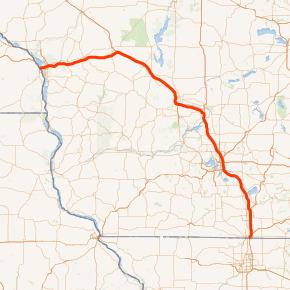
I-90 highlighted in red | ||||
| Route information | ||||
| Maintained by WisDOT | ||||
| Length | 187.13 mi[1] (301.16 km) | |||
| Major junctions | ||||
| West end | ||||
| East end | ||||
| Location | ||||
| Counties | La Crosse, Monroe, Juneau, Sauk, Columbia, Dane, Rock | |||
| Highway system | ||||
| ||||
All 187 miles of I-90 in Wisconsin have a speed limit of 70 mph.
Route description

The highway enters from Minnesota over the Mississippi River just northwest of La Crosse. The freeway passes north of La Crosse and south of Onalaska as it heads towards Tomah. Once there, it joins I-94. The two Interstates run concurrently for the next 91.76 miles (147.67 km) to Madison. The highway collects Interstate 39, 63 miles (101 km) southeast of Tomah (near Portage). This concurrency of about 30 miles (48 km) is one of only two three-route concurrency of the Interstate Highway System existence, the other being in Milwaukee. I-39 continues along I-90 for the remaining 78 miles (126 km) in Wisconsin.
I-94 breaks away eastward toward Milwaukee at what is commonly known as the Badger Interchange, where the three Interstates meet with WIS 30. The remaining routes continue south to Janesville and Beloit before exiting the state.
Exit list
| County | Location | mi[1] | km | Exit | Destinations | Notes |
|---|---|---|---|---|---|---|
| Mississippi River | 0.00 | 0.00 | Continuation into Minnesota | |||
| I-90 Mississippi River Bridge | ||||||
| La Crosse | Town of Campbell | 1.96 | 3.15 | 2 | ||
| La Crosse | 2.87 | 4.62 | 3 | Western end of US 53 concurrency | ||
| 4.43 | 7.13 | 4 | Eastern end of US 53 concurrency | |||
| 5.74 | 9.24 | 5 | ||||
| Town of Hamilton | 11.78 | 18.96 | 12 | |||
| Bangor | 15.57 | 25.06 | 15 | |||
| Monroe | Sparta | 24.91 | 40.09 | 25 | ||
| Town of Angelo | 28.18 | 45.35 | 28 | |||
| Town of Tomah | 41.42 | 66.66 | 41 | |||
| Tomah | 43.32 | 69.72 | 43 | |||
| Town of Oakdale | 45.10 | 72.58 | 45 | Western end of I-94 concurrency; I-94 exit 147 | ||
| Oakdale | 48.60 | 78.21 | 48 | |||
| Juneau | Camp Douglas | 55.03 | 88.56 | 55 | ||
| New Lisbon | 61.46 | 98.91 | 61 | |||
| Town of Lemonweir | 69.02 | 111.08 | 69 | |||
| Lyndon Station | 78.97 | 127.09 | 79 | |||
| Town of Lyndon | 85.40 | 137.44 | 85 | |||
| Sauk | Wisconsin Dells | 87.22 | 140.37 | 87 | ||
| Lake Delton | 89.80 | 144.52 | 89 | |||
| Town of Delton | 93.13 | 149.88 | 92 | |||
| Columbia | Town of Caledonia | 105.73 | 170.16 | 106 | ||
| 108.16– 108.59 | 174.07– 174.76 | 108A | ||||
| 108B | Western end of I-39 concurrency | |||||
| Town of Dekorra | 115.21 | 185.41 | 115 | |||
| Town of Arlington | 119.20 | 191.83 | 119 | |||
| Dane | Town of Vienna | 126.25 | 203.18 | 126 | ||
| Community of Windsor | 130.46 | 209.96 | 131 | |||
| Town of Burke | 131.98 | 212.40 | 132 | |||
| Madison | 135.21– 135.24 | 217.60– 217.65 | 135A | Cloverleaf interchange | ||
| 135B | ||||||
| 135.45 | 217.99 | 135C | High Crossing Boulevard | Westbound exit and eastbound entrance | ||
| 137.24 | 220.87 | 138A | Eastern end of I-94 concurrency; left exit and entrance eastbound; I-94 exit 240 | |||
| 137.59 | 221.43 | 138B | Left exit and entrance westbound; serves Dane County Airport; WIS 30 exit 3 eastbound exit 240A westbound | |||
| Town of Blooming Grove | 141.43 | 227.61 | 142 | Signed as exits 142A (west) and 142B (east); US 12 exit 267 | ||
| Town of Pleasant Springs | 146.80 | 236.25 | 147 | |||
| Town of Christiana | 155.90 | 250.90 | 156 | Western end of US 51 concurrency | ||
| Town of Albion | 159.64 | 256.92 | 160 | Eastern end of US 51 concurrency | ||
| Rock | Town of Fulton | 162.57 | 261.63 | 163 | ||
| Janesville | 170.81 | 274.89 | 171A | |||
| 171.52– 171.57 | 276.03– 276.12 | 171B | Formerly split into exits 171B (west) and 171C (east) | |||
| 174.71 | 281.17 | 175 | Western end of WIS 11 concurrency; former Bus. US 14 | |||
| Town of La Prairie | 177.22 | 285.21 | 177 | Eastern end of WIS 11 concurrency | ||
| Town of Turtle | 182.41 | 293.56 | 183 | |||
| 184.70 | 297.25 | 185A | ||||
| 184.68 | 297.21 | 185B | I-43 exit 1 | |||
| 187.13 | 301.16 | Continuation into Illinois | ||||
1.000 mi = 1.609 km; 1.000 km = 0.621 mi
| ||||||
References
- Southwest Region Staff (December 31, 2008). State Trunk Highway Log for Southwest Region (XLS). Madison, WI: Wisconsin Department of Transportation. 090E.
External links
![]()
- I-90 at Wisconsin Highways
| Previous state: Minnesota |
Wisconsin | Next state: Illinois |