Toorak, Victoria
Toorak (/ˈtʊəræk/)[2] is an inner suburb of Melbourne, Victoria, Australia, 5 km south-east of Melbourne's Central Business District, located within the City of Stonnington local government area. Toorak recorded a population of 12,909 at the 2016 Census.
| Toorak Melbourne, Victoria | |||||||||||||||
|---|---|---|---|---|---|---|---|---|---|---|---|---|---|---|---|
 Toorak | |||||||||||||||
| Coordinates | 37.841°S 145.018°E | ||||||||||||||
| Population | 12,909 (2016)[1] | ||||||||||||||
| • Density | 3,000/km2 (7,780/sq mi) | ||||||||||||||
| Established | 1850s | ||||||||||||||
| Postcode(s) | 3142 | ||||||||||||||
| Area | 4.3 km2 (1.7 sq mi) | ||||||||||||||
| Location | 5 km (3 mi) from Melbourne | ||||||||||||||
| LGA(s) | City of Stonnington | ||||||||||||||
| State electorate(s) | |||||||||||||||
| Federal Division(s) | Higgins | ||||||||||||||
| |||||||||||||||
The name Toorak has become synonymous with wealth and privilege, the suburb long having the reputation of being Melbourne's most elite, and ranking among the most prestigious in Australia. It has the highest average property values in Melbourne, and is one of the most expensive suburbs in Australia. It is the nation's second highest earning postcode after Point Piper in Sydney.[3]
Located on a rise on the south side (or left bank) of a bend in the Yarra River, Toorak is bordered by South Yarra, at Williams Road on the west, Malvern, at Glenferrie Road on the east, Prahran and Armadale, at Malvern Road to the south and the suburbs of Richmond, Burnley and Hawthorn on the north side of the river. The suburb's main street is considered to be Toorak Road, on which the commercial area of Toorak Village is located.
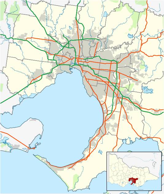
Toorak is named after Toorak House, the 1849-built residence of James Jackson, a merchant.
The suburb has also been a preferred location for many consulate offices and their residences, including China, USA, Britain, Monaco, Sweden, Turkey, and Switzerland.
History
Toponymy
Toorak was named after Toorak House, an Italianate residence built by James Jackson, a merchant, in 1849. The name of the house may have originated from Woiwurrung language, with words of similar pronunciation meaning black crow or reedy swamp.[4]
Toorak House
From 1854 Toorak House served as the residence of the first Governor of Victoria, Captain Sir Charles Hotham KCB RN and his successors, until the completion of the present Government House (1876) in the Kings Domain.
Toorak Post Office opened around June 1858.[5]
1880s land boom
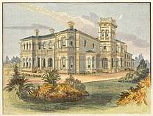
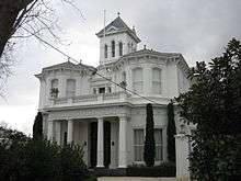
During the land boom of the 1880s, many large and elaborate mansions were erected in Toorak, often in the Italianate style. Following East Melbourne and then St Kilda, Toorak, along with Brighton, became the new favored location for the wealthy.
1890s depression
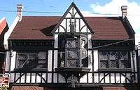
The suburb was hit particularly hard by the 1890s economic depression and many wealthy landowners declared bankruptcy and were forced to sell. Nonetheless, the suburb remained and is still Melbourne's home of "old money". During the Interwar period, many houses were built in the Tudor revival style; many houses were also designed by society Architect Marcus Martin in the Moderne style over a Georgian building form.[6]
Post-war era
In the period of post-World War II prosperity, rising standards of living and land values caused Toorak to become highly sought after by a new generation of the wealthy, thought by some to be social climbers and Nouveau riche. For some of these people, the focus was simply to have the postcode of Toorak, which was SE 2 and now 3142. As a result, many of the larger mansions were demolished and large holdings were subdivided to make way for flats, townhouses and apartments.
In the 1980s, larger houses in Neo-Georgian and Neo-Classical styles began to appear.
Contemporary Toorak
While large mansions have survived in neighbouring Hawthorn, Kew and Armadale, only a few of the original 19th-century mansions in Toorak remain, due in part to the high land value. Two of the most notable are Illawarra House, which was acquired by the National Trust; and Coonac, the most expensive house in Melbourne.[7] In Toorak, some of the old property names live on as street names or the names of blocks of flats, carved out of or built on their sites; Dunraven, Millicent, Iona, Woorigoleen, Myoora, and Scotsburn are examples.
Demographics
In the 2016 Census, there were 12,909 people in Toorak
- 63.9% of people were born in Australia. The next most common countries of birth were China (excludes SARs and Taiwan) 3.6%, England 3.1%, New Zealand 2.2%, India 1.8% and Malaysia 1.2%.
- 73.7% of people spoke only English at home. Other languages spoken at home included Mandarin 4.5%, Cantonese 1.8%, Italian 1.4%, Greek 1.3% and French 0.9%.
- The most common responses for religion were No Religion 30.9%, Catholic 17.6% and Anglican 14.9%,
- Of the employed people in Toorak 4.0% worked in Legal Services. Other major industries of employment included Hospitals 3.7%, Real Estate Services 3.1%, General Practice Medical Services 2.9% and Clothing Retailing 2.7%.
- The proportion of Toorak residents with a Bachelor's degree or higher is 46.7%.[1]
Housing
Toorak has an unusual mix of high, low and medium-density housing, due to intense subdivision of larger lots in the 1880s, 1920s and 1960s. The predominant housing in Toorak (49.6%) is apartments, particularly walk-up flats.[8]
Single-family detached homes are also prevalent (30.2%). Some of these homes are in the form of traditional mansions or newer large residences on significant-sized estates, owned by Melbourne's wealthy and social elite. The architectural style of the mansions is predominantly Italianate and colonial. The premier residential streets of Toorak are generally considered by local real estate agents to be St. George's Road, Lansell Road, Hopetoun Road, Albany Road and Clendon Road. It is not unusual for Toorak houses to have extensive facilities, such as swimming pools and tennis courts behind solid gates and high walls to preserve the privacy of the residents.
There are also extant stands of semi-detached housing (20.1%), including terraces, which were traditionally fashionable with the middle class and later gentrified.[1]
Politics
Toorak falls within the federal electorate of Higgins. The seat of Higgins was created in 1949 and held by Harold Holt CH 1949–1967, Sir John Gorton PC GCMG AC CH 1968–1975, Roger Shipton OAM 1975–1990, Peter Costello AC 1990–2009 and Kelly O'Dwyer since 2009 (all on behalf of the Liberal Party of Australia).
At State level, it mostly falls within the electorate of Malvern (currently held by the Liberals' Michael O'Brien), with the western part of the suburb falling within the electorate of Prahran (currently held by Sam Hibbins on behalf the Australian Greens). At local council level, Toorak falls within the City of Stonnington.
Toorak has historically voted for conservative political parties. The Liberal Party retained the seat of Malvern in the 2018 State Election, although there was a 10.1% swing to the Australian Labour Party.[9]
Toorak Village
The Toorak Village is a strip of shops and cafes, located centrally in Toorak Road.
Places of worship
- Saint John's Anglican Church, an 1862 Gothic Revival bluestone church, designed by William Wardell, dominates the skyline of Toorak, with a large tower including a peal of bells and a distinctive sandstone broach spire. Saint John's, Toorak is one of the most popular wedding venue churches in Australia.
- Saint Peter's Roman Catholic Church, built in 1876 in the Gothic style
- Toorak Uniting Church (1876), in the Frenchified Gothic style
- Swedish Church
The Wesleyan Church (1877), formerly on the corner of Toorak and Williams Roads, was illegally demolished in 1990 by developers and later replaced by a block of flats.
Schools
Schools in Toorak include St Catherine's School, Loreto Mandeville Hall, St Kevin's College, Glamorgan (now Toorak Campus, the junior school of Geelong Grammar School) and Toorak Central School (1890).
Sport
The Royal South Yarra Lawn Tennis Club was founded in 1884 and is located in Toorak. Kooyong Stadium, former home of the Australian Open, is located on Glenferrie Road.
Transport
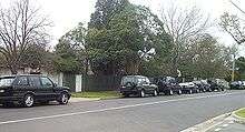
The most popular form of transport in Toorak is the automobile. CityLink runs along north eastern Toorak, though there are no interchanges within the suburb, although there is access to the freeway via MacRobertson Bridge and interchanges at Burnley. Main arterials running north–south are Williams Road (at the eastern boundary), Grange Road, Orrong Road, St Georges Road and Kooyong Road. The east–west arterials include Alexandra Avenue (at the northern boundary), Toorak Road (which runs midway through the suburb) and Malvern Road (at the southern boundary). Alexandra Avenue becomes St Georges Road and both along with Grange Road feed onto the MacRobertson Bridge, Toorak's main river crossing. Toorak's road planning is an example of street hierarchy. As a result, there are numerous quiet pedestrian streets. However, traffic congestion is an increasing problem along Toorak Road and Williams Roads. There is limited street parking along the main roads with just a couple of multi-storey car parks and parking lots within proximity of the main Toorak Road shopping strip. There are no level crossings in Toorak. There is a perception in popular culture of the luxury 4WD as a status symbol, (controversial for their comfort rather than for their off-road abilities)[10] and this has been associated with the suburb of Toorak, such that in popular Australian culture, the term 'Toorak Tractor' has become well established in Australian slang. An example of this was an episode of the popular program Top Gear Australia, aired on SBS TV, in which the presenters, tongue-in-cheek, drove a $200,000 tractor along Toorak Road.[11]
Toorak's only railway station is Heyington, on the Glen Waverley line, which crosses the Yarra from Richmond on the Heyington Railway Bridge, to the suburb's north. Despite its name, Toorak railway station is located in Armadale. The Pakenham, Frankston and Cranbourne railway line group to which this station belongs runs close to Toorak's southern boundary. Other nearby stations include Hawksburn, in South Yarra and Kooyong, in Kooyong.
Trams have run down Toorak Road since 1888. Route 58 runs along Toorak Road to Glenferrie Road, at the suburb's eastern boundary. Route 72 runs along Malvern Road, the suburb's southern boundary.
Cycling facilities are poor, with few marked on road lanes. MacRobertson Bridge and Gardiners Creek pedestrian bridge, however, the bridge provides pedestrians access to the Main Yarra Trail and shared bicycle and pedestrian paths in nearby Burnley. Pedestrians are serviced by an extensive network of footpaths and pedestrian crossings.
Residents
Celebrities, philanthropists, cultural figures
- Dame Zara Bate DBE – Fashion designer and wife of Harold Holt
- Lady Susan Renouf - socialite
- Albert Dadon AM – Chair of the Australian Israel Cultural Exchange
- Eddie McGuire AM – Journalist, sports commentator, television and radio personality, Australian republic advocate
- Paul Little AO and Jane Hansen, business people, philanthropists
- Daniel Radcliffe – his family owns a house in Toorak[12]
- Peter Robb – Australian author, born in Toorak in 1946
- Sidney Myer - philanthropist and founder of the Myer Emporium
- Sir Norman Myer - philanthropist and chairman of the Myer Emporium
- Dame Merlyn Myer DBE - philanthropist
- Martin Clemens CBE MC AM - war hero and philanthropist
- Dame Hilda Stevenson DBE - philanthropist
- Dame Elisabeth Murdoch AC DBE
- Tina Arena AM - singer/songwriter
- Gina Liano Real Housewife Of Melbourne
Politicians
- Harold Holt CH - Liberal Party politician, 17th Prime Minister of Australia
- Duncan Gillies – Colonial politician, 14th Premier of Victoria
- Malcolm Fraser AC CH – Liberal Party politician, 22nd Prime Minister of Australia
- Ted Baillieu – Victorian Liberal Party politician, 46th Premier of Victoria
- Sir Rupert Hamer AC KCMG ED - Liberal Party politician, former Premier of Victoria
- David Hamer AM DSC - Director of Naval Intelligence, Liberal Party Senator
- Sir William Murray McPherson KBE - Philanthropist and politician, 31st Premier of Victoria
Businesspeople
- John Munro Bruce - retail businessman, father of prime minister Stanley Bruce
- Lindsay Fox AC - Former Australian Rules footballer, owner of the Linfox transportation company
- Michael Gudinski AM - Entrepreneur and businessman
- Solomon Lew – Importer and retail supplier, current resident of Toorak
- Peter Lew – Managing director of Witchery clothing, son of Solomon Lew
- Keith Murdoch - journalist and newspaper owner
- Ziggy Switkowski AO – CEO of Telstra[13]
- Sir Donald Trescowthick AC KBE
- Ron Walker AC —CBE – Lord Mayor of Melbourne
- Alex Waislitz - Chairman & CEO of Thorney Investment group, vice president of the Collingwood Football Club
Sportspeople
- Lleyton Hewitt – Australian tennis player
- Tup Scott – cricketer
- Charlie McLeod – Australian test cricketer
- Jack Saunders – Australian test cricketer
- Clem Hill – Australian test cricketer
- Lou Richards MBE – Australian Rules footballer
- Nathan Buckley – Australian rules footballer[14]
- Andrew Demetriou – Chief Executive of the AFL[15]
- Walter Fellows – English-born vicar who hit a cricket ball for 175 yards, considered the world record
See also
- City of Malvern - Toorak was previously within this former local government area.
- City of Prahran - Toorak was previously within this former local government area.
References
- Australian Bureau of Statistics (27 June 2017). "Toorak (State Suburb)". 2016 Census QuickStats. Retrieved 21 September 2017.

- "ABC Pronounce". Australian Broadcasting Corporation. 19 July 1989. Retrieved 11 May 2020.
- https://finance.nine.com.au/2018/04/27/11/51/the-top-10-richest-postcodes-in-australia
- "Local Names". Malvern Historical Society. Retrieved 15 June 2016.
- "Post Office List". Premier Postal History. Retrieved 11 April 2008.
- "42 Wallace Avenue, Toorak, Statement of Significance". Heritage Council Victoria.
- Gough, Deborah (21 November 2002). "Toorak's grandest gets new owner". The Age. Melbourne. Retrieved 15 June 2016.
- "Toorak Suburb Profile & Demographics". propertyDATA.com.au. Retrieved 15 June 2016.
- "Victoria Votes, Results, Electorate: Malvern". Australian Broadcasting Corporation. 2018.
- Hale, Elini (28 December 2008). "Most drivers want a city 4WD ban". Herald Sun.
- Stevens, Mike (3 October 2008). "Top Gear Australia's Take On The Toorak Tractor". The Motor Report. Retrieved 15 June 2016.
- Ziffer, Daniel (18 May 2007). "Potter star down under". The Age. Melbourne. p. 6. Retrieved 7 October 2007.
- Yaxley, Louise (18 November 2002). "Senate focuses on Telstra chief's mobile coverage". PM. ABC Radio National. Retrieved 15 June 2016.
- Rindfleisch, Tony (8 April 2007). "Magpie flies to ritzy Toorak". Herald Sun. Melbourne. Retrieved 7 October 2007.
- Warner, Michael (22 November 2007). "We reveal AFL boss Andrew Demetriou's $7m Toorak base". Herald Sun. Melbourne.