City of Malvern
The City of Malvern was a local government area about 9 kilometres (6 mi) southeast of Melbourne, the state capital of Victoria, Australia. The city covered an area of 15.88 square kilometres (6.13 sq mi), and existed from 1856 until 1994, when it was merged with the City of Prahran to create the City of Stonnington.[2]
| City of Malvern Victoria | |||||||||||||||
|---|---|---|---|---|---|---|---|---|---|---|---|---|---|---|---|
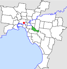 Location in Melbourne | |||||||||||||||
| Population | 43,600 (1992)[1] | ||||||||||||||
| • Density | 2,746/km2 (7,111/sq mi) | ||||||||||||||
| Established | 1856 | ||||||||||||||
| Area | 15.88 km2 (6.1 sq mi) | ||||||||||||||
| Council seat | Malvern | ||||||||||||||
| Region | Melbourne | ||||||||||||||
| County | Bourke | ||||||||||||||
 | |||||||||||||||
History
Malvern was incorporated as the Gardiner Road District on 17 October 1856, which became the Shire of Gardiner on 26 May 1871. It was renamed the Shire of Malvern on 15 February 1878. It then became a borough on 22 February 1901, a town on 24 April 1901 and a city on 30 May 1911.[3]
On 22 June 1994, the City of Malvern was abolished, and, along with the City of Prahran, was merged into the newly created City of Stonnington.[4]
Council meetings were held at the Malvern Town Hall, at Glenferrie Road and High Street, Malvern. It presently serves as a service centre for the City of Stonnington.
Mayors
Wards
The City of Malvern was subdivided in October 1980 into four wards — Centre, East, North and South — each electing three councillors.[3]
Suburbs
- Armadale (shared with the City of Prahran)
- Glen Iris (shared with the City of Camberwell)
- Kooyong
- Malvern
- Malvern East
- Toorak (shared with the City of Prahran)
Population
| Year | Population |
|---|---|
| 1954 | 46,910 |
| 1958 | 45,800* |
| 1961 | 47,870 |
| 1966 | 49,975 |
| 1971 | 50,560 |
| 1976 | 45,566 |
| 1981 | 43,211 |
| 1986 | 41,777 |
| 1991 | 41,340 |
* Estimate in the 1958 Victorian Year Book.
References
- Australian Bureau of Statistics, Victoria Office (1994). Victorian Year Book. p. 49. ISSN 0067-1223.
- Australian Bureau of Statistics (1 August 1995). Victorian local government amalgamations 1994-1995: Changes to the Australian Standard Geographical Classification (PDF). Commonwealth of Australia. p. 11. ISBN 0-642-23117-6. Retrieved 16 December 2007.
- Victorian Municipal Directory. Brunswick: Arnall & Jackson. 1992. pp. 411–412. Accessed at State Library of Victoria, La Trobe Reading Room.
- Australian Bureau of Statistics (1 August 1995). Victorian local government amalgamations 1994-1995: Changes to the Australian Standard Geographical Classification (PDF). Commonwealth of Australia. p. 11. ISBN 0-642-23117-6. Retrieved 16 December 2007.