Timeline of the 2014 Atlantic hurricane season
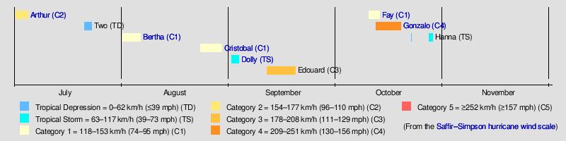
The 2014 Atlantic hurricane season was a below-average Atlantic hurricane season,[nb 1] featuring the fewest named storms since 1997.[2] The season officially began on June 1 and ended on November 30, dates that conventionally delimit the period of each year when most tropical cyclones develop in the Atlantic basin.[3] The season's first storm, Hurricane Arthur, developed on July 1; the season's final storm, Tropical Storm Hanna, degenerated on October 28.
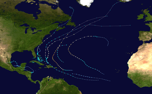
The season featured nine tropical cyclones, of which eight further intensified into tropical storms and six further intensified into hurricanes (including two major hurricanes).[nb 2] Impact throughout the year was widespread. In early July, Hurricane Arthur moved ashore near Cape Lookout, North Carolina, resulting in minor damage and one indirect death.[5][6] In August, hurricanes Bertha and Cristobal moved across the southwestern Atlantic, causing minimal damage and several fatalities.[7][8] In September, Tropical Storm Dolly moved ashore the coastline of eastern Mexico, killing one and inflicting unsubstantial damage,[9] while Hurricane Edouard created large swells that impacted the East Coast of the United States and killed two people.[10][11] In October, hurricanes Fay and Gonzalo moved ashore Bermuda, marking the first time more than one tropical cyclone made landfall on the island in a single season on record.[12] Hanna impacted Central America later that month but caused no damage.
This timeline includes information that was not operationally released, meaning that data from post-storm reviews by the National Hurricane Center, such as a storm that was not operationally warned upon, has been included. This timeline documents tropical cyclone formations, strengthening, weakening, landfalls, extratropical transitions, and dissipations during the season.
Timeline of events
June
- No tropical cyclones developed in the month of June.[13]
June 1
- The 2014 Atlantic hurricane season officially begins.[3]
July
July 1
- 00:00 UTC (8:00 p.m. EDT, June 30) – Tropical Depression One develops from an area of low pressure about 80 mi (130 km) [nb 3] north of Freeport, Bahamas.[6]
- 12:00 UTC (8:00 a.m. EDT) – Tropical Depression One intensifies into Tropical Storm Arthur roughly 70 mi (110 km) east of Fort Pierce, Florida.[6]
July 3
- 00:00 UTC (8:00 p.m. EDT, July 2) – Tropical Storm Arthur intensifies into a Category 1 hurricane approximately 145 mi (235 km) east-southeast of Savannah, Georgia.[6]
July 4
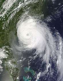
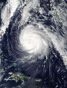
- 00:00 UTC (8:00 p.m. EDT, July 3) – Hurricane Arthur intensifies into a Category 2 hurricane about 35 mi (55 km) east of Carolina Beach, North Carolina and attains peak winds of 100 mph (160 km/h).[6]
- 03:15 UTC (11:15 p.m. EDT, July 3) – Hurricane Arthur makes its first landfall on Shackleford Banks, with winds of 100 mph (160 km/h), and simultaneously becomes the earliest hurricane to move ashore the coastline of North Carolina.[6]
- 06:00 UTC (2:00 a.m. EDT) – Hurricane Arthur attains a minimum barometric pressure of 973 mb (hPa; 28.73 inHg) roughly 15 mi (25 km) south of Engelhard, North Carolina.[6]
- 08:00 UTC (4:00 a.m. EDT) – Hurricane Arthur makes its second and final landfall just north of Oregon Inlet, North Carolina, with winds of 100 mph (160 km/h).[6]
- 12:00 UTC (8:00 a.m. EDT) – Hurricane Arthur weakens to a Category 1 hurricane approximately 85 mi (140 km) east of Virginia Beach, Virginia.[6]
July 5
- 06:00 UTC (2:00 a.m. EDT) – Hurricane Arthur weakens to a tropical storm about 210 km (130 mi) east of Provincetown, Massachusetts.[6]
- 12:00 UTC (9:00 a.m. AST) – Tropical Storm Arthur transitions into an extratropical cyclone over the Bay of Fundy.[6]
July 10
- 00:00 UTC (8:00 p.m. AST, July 9) – The extratropical cyclone of Arthur dissipates off the eastern coast of Labrador.[6]
July 21
- 12:00 UTC – Tropical Depression Two develops from an area of low pressure and simultaneously attains its peak intensity with maximum sustained winds of 35 mph (55 km/h) and a minimum barometric pressure of 1012 mb (hPa; 29.89 inHg) roughly 1,120 mi (1,800 km) east-southeast of Barbados.[14]
July 23
- 18:00 UTC – Tropical Depression Two degenerates into a trough of low pressure well east of the Lesser Antilles.[14]
August
August 1
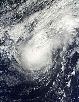
- 00:00 UTC – Tropical Storm Bertha develops from an area of low pressure approximately 345 mi (555 km) east-southeast of Barbados.[7]
August 3
- 14:00 UTC (10:00 a.m. EDT) – Tropical Storm Bertha makes landfall on Middle Caicos, Turks and Caicos Islands, with winds of 45 mph (75 km/h).[7]
August 4

- 12:00 UTC (8:00 a.m. EDT) – Tropical Storm Bertha intensifies into a Category 1 hurricane and simultaneously attains its peak intensity with maximum sustained winds of 80 mph (130 km/h) and a minimum barometric pressure of 998 mb (hPa; 29.47 inHg) about 195 mi (315 km) north-northeast of San Salvador Island, Bahamas.[7]
August 5
- 06:00 UTC – Hurricane Bertha weakens to a tropical storm roughly 300 mi (485 km) southeast of Wilmington, North Carolina.[7]
August 6
- 18:00 UTC – Tropical Storm Bertha transitions into an extratropical cyclone approximately 290 mi (465 km) south-southeast of Halifax, Nova Scotia.[7]
August 9
- 18:00 UTC – The extratropical cyclone of Bertha degenerates into a trough over the north-central Atlantic Ocean.[7]
August 23
- 18:00 UTC (2:00 p.m. AST) – Tropical Depression Four develops from an area of low pressure about 15 mi (25 km) southeast of Providenciales, Turks and Caicos Islands.[8]
August 24
- 06:00 UTC (2:00 a.m. AST) – Tropical Depression Four intensifies into Tropical Storm Cristobal roughly 15 mi (25 km) north of Mayaguana, Bahamas.[8]
August 26
- 00:00 UTC (8:00 p.m. EDT, August 25) – Tropical Storm Cristobal intensifies into a Category 1 hurricane approximately 165 mi (265 km) north-northeast of San Salvador Island, Bahamas.[8]
August 28
- 1800 UTC – Hurricane Cristobal attains peak winds of 85 mph (140 km/h) about 360 mi (580 km) north of Bermuda.[8]
August 29
- 00:00 UTC – Hurricane Cristobal attains a minimum barometric pressure of 965 mb (hPa; 28.50 inHg) roughly 575 mi (925 km) north-northeast of Bermuda.[8]
- 12:00 UTC – Hurricane Cristobal transitions into an extratropical cyclone approximately 390 mi (630 km) east-southeast of Saint-Pierre, Newfoundland.[8]
September
September 1
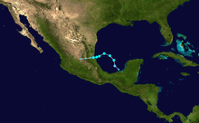
- 18:00 UTC – Tropical Depression Five develops from an area of low pressure about 340 mi (545 km) east-southeast of Tampico, Mexico.[9]
September 2
- 00:00 UTC – Tropical Depression Five intensifies into Tropical Storm Dolly roughly 295 mi (475 km) east-southeast of Tampico, Mexico.[9]
- 12:00 UTC – The extratropical cyclone of Cristobal merges with a second cyclone over the far northern Atlantic.[8]
- 12:00 UTC (7:00 a.m. CDT) – Tropical Storm Dolly attains peak winds of 50 mph (80 km/h) approximately 150 mi (240 km) northeast of Tampico, Mexico.[9]
September 3
- 01:00 UTC (8:00 p.m. CDT, September 2) – Tropical Storm Dolly attains a minimum barometric pressure of 1000 mb (hPa; 29.53 inHg) about 35 mi (55 km) southeast of Tampico, Mexico.[9]
- 04:00 UTC (11:00 p.m. CDT, September 2) – Tropical Storm Dolly makes landfall just south of Tampico, Mexico, with winds of 45 mph (70 km/h).[9]
- 12:00 UTC (7:00 a.m CDT) – Tropical Storm Dolly degenerates into a non-convective remnant area of low pressure roughly 20 mi (30 km) southeast of Ciudad Valles, Mexico.[9]
September 4
- 06:00 UTC (1:00 a.m. CDT) – The remnant low of Dolly dissipates over central Mexico.[9]
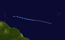
September 11
- 12:00 UTC – Tropical Depression Six develops from an area of low pressure approximately 830 mi (1,335 km) west of the Cape Verde Islands.[11]
September 12
- 00:00 UTC – Tropical Depression intensifies into Tropical Storm Edouard about 920 mi (1,480 km) west of the Cape Verde Islands.[11]
September 14
- 12:00 UTC – Tropical Storm Edouard intensifies into a Category 1 hurricane roughly 1,035 mi (1,665 km) southeast of Bermuda.[11]
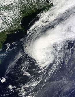
September 15
- 06:00 UTC – Hurricane Edouard intensifies into a Category 2 hurricane approximately 765 mi (1,230 km) southeast of Bermuda.[11]
September 16
- 06:00 UTC – Hurricane Edouard intensifies into a Category 3 major hurricane, the first in the Atlantic basin since 2012's Sandy, about 485 mi (780 km) southeast of Bermuda.[11]
- 12:00 UTC – Hurricane Edouard attains its peak intensity with maximum sustained winds of 120 mph (195 km/h) and a minimum barometric pressure of 955 mb (hPa; 28.20 inHg) roughly 415 mi (670 km) east of Bermuda.[11]
- 18:00 UTC – Hurricane Edouard weakens to a Category 2 hurricane approximately 420 mi (675 km) east of Bermuda.[11]
September 17
- 12:00 UTC – Hurricane Edouard weakens to a Category 1 hurricane about 645 mi (1,040 km) northeast of Bermuda.[11]
September 19
- 00:00 UTC – Hurricane Edouard weakens to a tropical storm roughly 480 mi (770 km) west-southwest of the western Azores.[11]
- 18:00 UTC – Tropical Storm Edouard degenerates into a non-convective remnant area of low pressure approximately 460 mi (740 km) west of the western Azores.[11]
September 22
- 12:00 UTC – The remnant low of Edouard merges with a frontal boundary well south-southwest of the Azores.[11]
October
October 10
- 06:00 UTC – Subtropical Storm Fay develops from an area of low pressure about 615 mi (990 km) south of Bermuda.[15]
October 11
- 06:00 UTC – Subtropical Storm Fay transitions into a fully tropical cyclone roughly 435 mi (700 km) south of Bermuda.[15]
October 12
- 00:00 UTC – A tropical depression develops from an area of low pressure approximately 390 mi (630 km) east of the Leeward Islands.[12]
- 06:00 UTC (2:00 a.m. AST) – Tropical Storm Fay intensifies into a Category 1 hurricane about 40 mi (65 km) south of Bermuda.[15]
- 08:10 UTC (4:10 a.m. AST) – Hurricane Fay attains peak winds of 80 mph (130 km/h) and simultaneously makes landfall on Bermuda, becoming the first hurricane to do so since 1987's Emily.[15]
- 12:00 UTC (8:00 a.m. AST) – Hurricane Fay attains a minimum barometric pressure of 983 mb (hPa; 29.03 inHg) roughly 75 mi (120 km) northeast of Bermuda.[15]
- 12:00 UTC (8:00 a.m. AST) – The tropical depression intensifies into Tropical Storm Gonzalo approximately 255 mi (410 km) of Antigua.[12]
- 18:00 UTC (2:00 p.m. AST) – Hurricane Fay weakens to a tropical storm about 190 mi (305 km) northeast of Bermuda.[15]
October 13
- 06:00 UTC – Tropical Storm Fay degenerates into a trough of low pressure over the north-central Atlantic.[15]
- 12:00 UTC (8:00 a.m. AST) – Tropical Storm Gonzalo intensifies into a Category 1 hurricane roughly 10 mi (15 km) east-southeast of Antigua.[12]
- 14:30 UTC (10:30 a.m. AST) – Hurricane Gonzalo makes its first landfall on Antigua with winds of 75 mph (120 km/h).[12]
- 22:45 UTC (6:45 p.m. AST) – Hurricane Gonzalo makes its second landfall on Saint Martin with winds of 85 mph (135 km/h).[12]
- 23:15 UTC (7:15 p.m. AST) – Hurricane Gonzalo makes its third landfall on Anguilla with winds of 85 mph (135 km/h).[12]
October 14
- 06:00 UTC (2:00 a.m. AST) – Hurricane Gonzalo intensifies into a Category 2 hurricane approximately 40 mi (65 km) northeast of Anegada.[12]
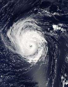
- 18:00 UTC (2:00 p.m. AST) – Hurricane Gonzalo intensifies into a Category 3 hurricane about 165 mi (265 km) north of San Juan, Puerto Rico.[12]
October 15
- 00:00 UTC – Hurricane Gonzalo intensifies into a Category 4 hurricane roughly 225 mi (360 km) north of San Juan, Puerto Rico.[12]
- 18:00 UTC – Hurricane Gonzalo weakens to a Category 3 hurricane approximately 245 mi (395 km) northeast of Cockburn Town, Turks and Caicos.[12]
October 16
- 06:00 UTC – Hurricane Gonzalo re-intensifies into a Category 4 hurricane about 295 mi (475 km) north-northeast of Cockburn Town, Turks and Caicos.[12]
- 12:00 UTC – Hurricane Gonzalo attains its peak intensity with maximum sustained winds of 145 mph (235 km/h) and a minimum barometric pressure of 940 mb (hPa; 27.76 inHg) roughly 530 mi (855 km) south-southwest of Bermuda.[12]
October 17
- 12:00 UTC (8:00 a.m. AST) – Hurricane Gonzalo weakens to a Category 3 hurricane for a second time approximately 195 mi (315 km) south-southwest of Bermuda.[12]
October 18
- 00:00 UTC (8:00 p.m. AST, October 17) – Hurricane Gonzalo weakens to a Category 2 hurricane about 5 mi (10 km) south-southwest of Bermuda.[12]
- 00:30 UTC (8:30 p.m. AST, October 17) – Hurricane Gonzalo makes landfall on Bermuda with winds of 110 mph (175 km/h), becoming the strongest hurricane to affect the island since 2003's Hurricane Fabian and the strongest October hurricane to make landfall on the island since 1926.[12]
October 19
- 06:00 UTC – Hurricane Gonzalo weakens to a Category 1 hurricane roughly 170 mi (275 km) southeast of Saint-Pierre, Newfoundland.[12]
- 18:00 UTC – Hurricane Gonzalo transitions into an extratropical cyclone approximately 415 mi (670 km) northeast of St. John's, Newfoundland.[12]
October 20
- 12:00 UTC – The extratropical remnants of Hurricane Gonzalo is absorbed by a cold front over the north-central Atlantic Ocean.[12]
October 22
- 00:00 UTC – Tropical Depression Nine develops from an area of low pressure about 175 mi (280 km) west of Campeche, Mexico.[16]
October 23
- 00:00 UTC – Tropical Depression Nine degenerates into a non-convective remnant area of low pressure roughly 65 mi (105 km) southwest of Campeche, Mexico.[16]
October 27
- 00:00 UTC (7:00 p.m. CST, October 26) – The remnants of Tropical Depression Nine regenerate into a tropical depression approximately 80 mi (130 km) east of the Nicaragua–Honduras border.[16]
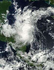
- 06:00 UTC (1:00 a.m. CST) – Tropical Depression Nine intensifies into Tropical Storm Hanna and simultaneously attains its peak intensity with maximum sustained winds of 40 mph (65 km/h) and a minimum barometric pressure of 1005 mb (hPa; 29.68 inHg) about 50 mi (80 km) east of the Nicaragua–Honduras border.[16]
- 16:00 UTC (11:00 a.m. CST) – Tropical Storm Hanna makes landfall near the Nicaragua–Honduras border with winds of 40 mph (65 km/h).[16]
- 18:00 UTC (1:00 p.m. CST) – Tropical Storm Hanna weakens to a tropical depression roughly 255 mi (410 km) east-northeast of Tegucigalpa, Honduras.[16]
October 28
- 06:00 UTC (1:00 a.m. CST) – Tropical Depression Hanna degenerates into a non-convective remnant area of low pressure approximately 60 mi (95 km) northeast of Catacamas, Honduras.[16]
October 30
Footnotes
- An average season, as defined by the National Oceanic and Atmospheric Administration, has twelve tropical storms, six hurricanes and two major hurricanes.[1]
- A major hurricane is a storm that ranks as Category 3 or higher on the Saffir–Simpson hurricane wind scale.[4]
- The figures for maximum sustained winds and position estimates are rounded to the nearest 5 units (knots, miles, or kilometers), following the convention used in the National Hurricane Center's operational products for each storm. All other units are rounded to the nearest digit.
References
- "Background Information: The North Atlantic Hurricane Season". Climate Prediction Center Internet Team. Climate Prediction Center. August 4, 2011. Retrieved December 5, 2011.
- Brian K. Sullivan (November 25, 2014). "Snowy End to Hurricane Season That Many Never Noticed". Bloomberg Business. Retrieved May 19, 2015.
- Christopher W. Landsea; Neal Dorst; Erica Rule (June 2, 2011). "G: Tropical Cyclone Climatology". Hurricane Research Division: Frequently Asked Questions. Atlantic Oceanographic and Meteorological Laboratory. National Oceanic and Atmospheric Administration. G1) When is hurricane season ?. Retrieved March 3, 2014.
- Chris Landsea; Neal Dorst (ed.) (June 2, 2011). "A: Basic Definitions". Hurricane Research Division: Frequently Asked Questions. Atlantic Oceanographic and Meteorological Laboratory. A3) What is a super-typhoon? What is a major hurricane ? What is an intense hurricane ?. Retrieved December 27, 2011.CS1 maint: extra text: authors list (link)
- Staff writer (July 9, 2014). "Arthur power outage may have contributed to Woodstock death". CBC News. Retrieved May 19, 2015.
- Robbie J. Berg (April 20, 2015). Tropical Cyclone Report: Hurricane Arthur (PDF) (Report). Miami, Florida: National Hurricane Center. pp. 2, 3, 11, 12. Retrieved May 15, 2015.
- Eric S. Blake (February 23, 2015). Tropical Cyclone Report: Hurricane Bertha (PDF) (Report). Miami, Florida: National Hurricane Center. pp. 2, 3, 5, 6. Retrieved May 15, 2015.
- Richard J. Pasch (February 11, 2015). Tropical Cyclone Report: Hurricane Cristobal (PDF) (Report). Miami, Florida: National Hurricane Center. pp. 2, 3, 5, 6. Retrieved May 15, 2015.
- John L. Beven II (January 28, 2015). Tropical Cyclone Report: Tropical Storm Dolly (PDF) (Report). Miami, Florida: National Hurricane Center. pp. 2, 5. Retrieved May 16, 2015.
- Staff writer (September 18, 2014). "Strong Rip Currents Kill Two Men in Ocean City". NBC Washington. Retrieved May 19, 2015.
- Stacy R. Stewart (December 10, 2014). Tropical Cyclone Report: Hurricane Edouard (PDF) (Report). Miami, Florida: National Hurricane Center. pp. 2, 3, 6, 7. Retrieved May 16, 2015.
- Daniel P. Brown (March 4, 2015). Tropical Cyclone Report: Hurricane Gonzalo (PDF) (Report). Miami, Florida: National Hurricane Center. pp. 2, 3, 5, 9, 10. Retrieved May 18, 2015.
- Hurricane Specialist Unit (July 1, 2014). Monthly Tropical Weather Summary (TXT) (Report). National Hurricane Center. Retrieved July 16, 2015.
- Lixion A. Avila (September 24, 2014). Tropical Cyclone Report: Tropical Depression Two (PDF) (Report). Miami, Florida: National Hurricane Center. pp. 2, 4. Retrieved May 15, 2015.
- Todd B. Kimberlain (April 24, 2015). Tropical Cyclone Report: Hurricane Fay (PDF) (Report). Miami, Florida: National Hurricane Center. pp. 2, 7. Retrieved May 18, 2015.
- John P. Cangialosi (December 16, 2014). Tropical Cyclone Report: Tropical Storm Hanna (PDF) (Report). Miami, Florida: National Hurricane Center. pp. 2, 3, 5, 6. Retrieved May 18, 2015.
External links
![]()
- The National Hurricane Center (NHC)'s 2014 Tropical Cyclone Advisory Archive
- The National Climatic Data Center (NCDC)'s 2014 Annual Tropical Cyclones Report
Tropical cyclones of the 2014 Atlantic hurricane season | ||
|---|---|---|
| ||
| ||
| Preceded by 2013 |
Atlantic hurricane season timelines 2014 |
Succeeded by 2015 |