Middle Caicos
Middle Caicos is the largest island in the Turks and Caicos Islands. To the west, it is separated from North Caicos by Juniper Hole, and to the east, from East Caicos by Lorimer Creek, both narrow passages that can accommodate only small boats. The island is known for its extensive system of caves and its significant Lucayan Indian archeological sites. The island is connected to North Caicos via a causeway. Middle Caicos was previously called Grand Caicos, although this name is not used today.
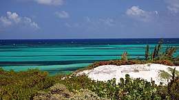 A view of the Caribbean from Middle Caicos | |
 Middle Caicos The location of Middle Caicos within the Turks and Caicos Islands  Middle Caicos Middle Caicos (Caribbean) | |
| Geography | |
|---|---|
| Location | Atlantic Ocean |
| Coordinates | 21°47′17.49″N 71°44′4.35″W |
| Archipelago | Lucayan Archipelago |
| Area | 144.2 km2 (55.7 sq mi) |
| Administration | |
| British Overseas Territory | Turks and Caicos Islands |
| Demographics | |
| Population | 275 |
| Pop. density | 1.9/km2 (4.9/sq mi) |
| Additional information | |
| Time zone | |
| • Summer (DST) | |
| ISO code | TC |
| Official name | North, Middle & East Caicos Islands |
| Designated | 27 June 1990 |
| Reference no. | 493[1] |
Geography
The island has an area of 144.2 square kilometres (55.7 sq mi) within the high water mark, and of 294.1 square kilometres (113.6 sq mi) within the shoreline. The difference between the two values is not accounted for as land area. It is part of the North Caicos and Middle Caicos District.
Notable natural areas are the scenic Mudjin Harbour, located on the northern shore, and Conch Bar Caves. On the eastern part of the islands are the ruins of Haulover Plantation.[2] There are at least 38 Lucayan sites on Middle Caicos. Recent excavation has revealed that Middle Caicos was likely the principal settlement of Lucayan people in the sub tropics. Evidence of Lucayan settlements date back to 750 AD and archeologists believe that as many as 4,000 Indians once lived on the island.[3]
Population
The resident population of Middle Caicos is estimated to be 75.[4]
Middle Caicos Settlements
Lorimers
Located at the northeastern middle end the Island, this inland village is situated along lagoon inlet. It is the smallest of three villages on Middle Caicos with a population of only 36.
Bambarra
Located east of Conch Bar about half a mile inland, this village is the second largest settlement on Middle Caicos. It is notable as the only town in the Turks and Caicos Archipelago that has a name of African derivation. The village was reputedly first settled by survivors of the Spanish slave ship Trouvadore that sank off Middle Caicos in 1842.[5]
Conch Bar
The largest of the three villages on Middle Caicos, Conch Bar is the home of the Island’s airport, its primary school and government offices. Nearby Conch Bar Caves National Park hosts the largest above-water cave system in the Bahamas. The karst limestone caves were used as a guano mine during the 1880s. Lucayan Indian artifacts and the skeletal remains of animals were reportedly uncovered by the digging, but were not preserved.[6]
References
- "North, Middle & East Caicos Islands". Ramsar Sites Information Service. Retrieved 25 April 2018.
- "Haulover Plantation". Visit Turks and Caicos Islands. Retrieved 2016-04-10.
- "Lucayans - Turks and Caicos National Museum". Turks and Caicos National Museum. Retrieved 2016-04-10.
- "Vaping in 2014: Vape Pens, Tanks, and E-liquid Reviews!". smoking.vaporizerviews.com. Archived from the original on 2013-06-03. Retrieved 2016-04-10.
- Leshikar-Denton, Margaret E.; Erreguerena, Pilar Luna (2008-10-15). Underwater and Maritime Archaeology in Latin America and the Caribbean. Left Coast Press. ISBN 9781598742626.
- "Conch Bar Caves". Visit Turks and Caicos Islands. Retrieved 2016-04-10.