Tibes
Tibes (Barrio Tibes) is one of the 31 barrios in the municipality of Ponce, Puerto Rico. Together with Magueyes, Portugués, Montes Llanos, Maragüez, Machuelo Arriba, Sabanetas, and Cerrillos, barrio Tibes is one of the municipality's eight rural interior barrios. Tibes attracted attention recently when, in 1975, what was to become the discovery of the oldest cemetery in the West Indies came about as a result of rainstorms. The name of this barrio is of native Indian origin.[1] It was organized in 1831.[2]
Barrio Tibes | |
|---|---|
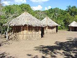 Barrio Tibes is home to the Tibes Indigenous Ceremonial Center | |
 Location of barrio Tibes within the municipality of Ponce shown in red | |
| Commonwealth | |
| Municipality | |
| Area | |
| • Total | 7.01 sq mi (18.2 km2) |
| • Land | 7.01 sq mi (18.2 km2) |
| • Water | 0.00 sq mi (0.0 km2) |
| Population (2000) | |
| • Total | 866 |
| • Density | 123.5/sq mi (47.7/km2) |
| Source: 2000 Census | |
Location
%2C_Ponce%2C_PR_(DSC02996A).jpg)
Tibes is a mountainous rural barrio located in the central section of the municipality, north of the city of Ponce.[3] Tibes is located on the foothills of the Cordillera Central. The toponomy, or origin of the name, is related to the hard, smooth stones plentiful in the rivers of this barrio and used by the indigenous peoples of the area as a weapon and the jíbaro countrymen for sharpening agricultural tools such as the machete.[4]
Boundaries
Tibes is bounded on the North by the hills just north of El Principe Road, on the South by Tibes Road, on the West by the hills west of PR-10, and on the East by Pastillo Road, the hills west of Río Chiquito.[5][6]
In terms of barrio-to-barrio boundaries, Tibes is bounded in the North by Barrio San Patricio, in the South by Portugués, in the West by Guaraguao and Magueyes, and in the East by Barrios Monte Llano and Portugués.[7][8]
Features and demographics

Tibes has 7.01 square miles (18 km2) of land area and no water area. In 2000, the population of Tibes was 866 persons, and it had a density of 124 inhabitants per square mile.[9][10][11] Tibes is the second least populated barrio in Ponce, after San Patricio. Major roads serving Barrio Tibes are PR-10 and PR-503.[12]
The highest point in Barrio Tibes is Cerro del Diablo which stands at 2,234 feet. Another notable land feature is Cerro La Mesa which stands at 1,742 feet.[13] Rio Portugues is the main body of water running through this barrio.[14]
Portugues Dam
The Portugues Dam currently under construction and scheduled for completion in 2013, is also located in Barrio Tibes.[15]
See also
References
- Sunny A. Cabrera Salcedo. Hacia un Estudio Integral de la Toponimia del Municipio de Ponce, Puerto Rico. Ph. D. dissertation. May 1999. University of Massachusetts Amherst. Graduate School. Department of Spanish and Portuguese. Page 54.
- Barrios de Ponce. Archived 30 September 2015 at the Wayback Machine Antepasados Esclavos.(From: Pedro Tomás de Córdoba. Memorias geográficas, históricas, económicas y estadísticas de la Isla de Puerto Rico.) Retrieved 28 November 2014.
- City Melt Retrieved, February 26, 2010.
- Government of the Municipality of Ponce. Periódico "El Señorial". Special issue: Carnaval Ponceño 2013. February 2013. Page 17. Ponce, Puerto Rico.
- General Purpose Population Data, Census 2000. Unidad de Sistemas de Información Geográfica, Área de Tecnología de Información Gubernamental, Oficina de Gerencia y Presupuesto. Gobierno de Puerto Rico. Archived 12 August 2010 at the Wayback Machine Retrieved 20 February 2010.
- Ponce Topographic Map. Map Styles: Map and Shaded. Trails.com. From: United States Geological Survey. Topo Map. Projection: NAD83/WGS84. Retrieved 22 February 2010.
- General Purpose Population Data, Census 2000. Unidad de Sistemas de Información Geográfica, Área de Tecnología de Información Gubernamental, Oficina de Gerencia y Presupuesto. Gobierno de Puerto Rico. Archived 12 August 2010 at the Wayback Machine Retrieved 27 February 2010.
- Mapa de Localizacion Limite de Barrios de Ponce. Retrieved 27 February 2010.
- City Melt Retrieved 27 February 2010.
- U.S. Census Bureau. Census 2000. Ponce and Its Barrios. (Ponce Municipio, Puerto Rico -- County Subdivision and Place. GCT-PH1. Population, Housing Units, Area, and Density: 2000. Data Set: Census 2000 Summary File 1 (SF 1) 100-Percent Data) Archived 12 February 2020 at Archive.today Retrieved 26 February 2010.
- "CENSUS2". Archived from the original on 12 February 2020. Retrieved 28 February 2010.
- General Purpose Population Data, Census 2000. Unidad de Sistemas de Información Geográfica, Área de Tecnología de Información Gubernamental, Oficina de Gerencia y Presupuesto. Gobierno de Puerto Rico. Archived 12 August 2010 at the Wayback Machine Retrieved 27 February 2010.
- Maptest. Archived 18 February 2010 at the Wayback Machine Government of the Commonwealth of Puerto Rico. General Purpose Population Data, Census 2000. Unidad de Sistemas de Información Geográfica, Área de Tecnología de Información Gubernamental, Oficina de Gerencia y Presupuesto. Gobierno de Puerto Rico. Retrieved 10 November 2011.
- El barrio Tibes: cuna de uno de las más antiguos asentamientos del país. Ernie Xavier Rivera Collazo. La Perla del Sur. Year 36. Issue 1860. 24–30 July 2019. pp. 14-15. Accessed 25 July 2019.
- Website of the Municipality of Ponce. Descubrelo > Recursos Naturales. Archived 20 June 2010 at the Wayback Machine
- U.S. Geological Survey Geographic Names Information System: Tibes Barrio