Maragüez
Maragüez (Barrio Maragüez) is one of the 31 barrios of the municipality of Ponce, Puerto Rico. Along with Magueyes, Tibes, Portugués, Montes Llanos, Machuelo Arriba, Sabanetas, and Cerrillos, Maragüez is one of the municipality's eight rural interior barrios. The name of this barrio is of native Indian origin.[1] It was created in 1878.[2]
Barrio Maragüez | |
|---|---|
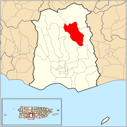 Location of barrio Maragüez within the municipality of Ponce shown in red | |
| Commonwealth | |
| Municipality | |
| Area | |
| • Total | 6.42 sq mi (16.6 km2) |
| • Land | 5.31 sq mi (13.8 km2) |
| • Water | 1.11 sq mi (2.9 km2) |
| Population (2000) | |
| • Total | 754 |
| • Density | 142/sq mi (55/km2) |
| Source: 2000 Census | |
Location
Maragüez is a rural barrio located in the northeastern section of the municipality, northeast of the city of Ponce at latitude 18.106178 N, and longitude -66.595986 W.[3]
Boundaries
It is bounded on the North by barrios Anón and San Patricio, in the South by barrio Cerrillos, in the West by barrios Monte Llano and Machuelo Arriba, and in the East by barrios Anón and Real. Río Cerrillos runs a large stretch of its course through barrio Maragüez, and is known locally (and unofficially) as Rio Maragüez.
Features and demographics
.jpg)
In 1920 Maragüez had a population of 616 inhabitants.[4] By 2000, the population of Maragüez had grown to only 754 persons, making it the fourth least populated barrio of the municipality after 80 years.[5] At 142 persons per square mile, Maragüez is also the fourth least densely populated barrio in the municipality.[6] The main road serving barrio Maragüez is PR-139.[7]
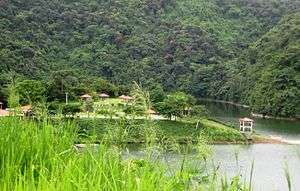
The highest point in Barrio Maragüez stands at 2,132 feet and is located at the extreme northeast tip of the barrio. Another notable land feature is the Cerro Santo Domingo which stands at 2,004 feet.[8]
Landmarks
The Cerrillos Dam over Río Cerrillos is located in barrio Maraguez.[9] Cerrillos Lake is located in Barrio Maragüez.
See also
References
- Sunny A. Cabrera Salcedo. Hacia un Estudio Integral de la Toponimia del Municipio de Ponce, Puerto Rico. Ph. D. dissertation. May 1999. University of Massachusetts Amherst. Graduate School. Department of Spanish and Portuguese. Page 54.
- Barrios de Ponce. Archived 30 September 2015 at the Wayback Machine Antepasados Esclavos.(From: Pedro Tomás de Córdoba. Memorias geográficas, históricas, económicas y estadísticas de la Isla de Puerto Rico.) Retrieved 28 November 2014.
- City Melt Retrieved, March 21, 2010.
- 1920 Census
- Ponce, Puerto Rico: Barrios. Areciboweb. Retrieved, February 14, 2010.
- U.S. Census Bureau. Census 2000. Ponce and Its Barrios. (Ponce Municipio, Puerto Rico -- County Subdivision and Place. GCT-PH1. Population, Housing Units, Area, and Density: 2000. Data Set: Census 2000 Summary File 1 (SF 1) 100-Percent Data) Archived 12 February 2020 at Archive.today Retrieved February 26, 2010.
- General Purpose Population Data, Census 2000. Unidad de Sistemas de Información Geográfica, Área de Tecnología de Información Gubernamental, Oficina de Gerencia y Presupuesto. Gobierno de Puerto Rico. Archived 2010-08-12 at the Wayback Machine Retrieved February 22, 2010.
- Maptest. Archived 2010-02-18 at the Wayback Machine Government of the Commonwealth of Puerto Rico. General Purpose Population Data, Census 2000. Unidad de Sistemas de Información Geográfica, Área de Tecnología de Información Gubernamental, Oficina de Gerencia y Presupuesto. Gobierno de Puerto Rico. Retrieved 10 November 2011.
- Cerrillos Dam Archived 2009-07-14 at the Wayback Machine Retrieved March 21, 2010.
- U.S. Geological Survey Geographic Names Information System: Maragüez Barrio