Magueyes, Ponce, Puerto Rico
Magueyes is one of the 31 barrios of the municipality of Ponce, Puerto Rico. Together with Cerrillos, Machuelo Arriba, Maragüez, Montes Llanos, Portugués, Sabanetas, and Tibes, Magueyes is one of the municipality's eight interior barrios. The name of this barrio is of native Indian origin.[1] It was created in 1831.[2]
Barrio Magueyes | |
|---|---|
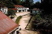
.jpg) Scene in Barrio Magueyes | |
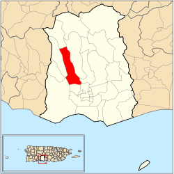 Location of barrio Magueyes within the municipality of Ponce shown in red | |
| Commonwealth | |
| Municipality | |
| Area | |
| • Total | 4.56 sq mi (11.8 km2) |
| • Land | 4.56 sq mi (11.8 km2) |
| • Water | 0.00 sq mi (0.0 km2) |
| Population (2000) | |
| • Total | 6,134 |
| • Density | 1,345/sq mi (519/km2) |
| Source: 2000 Census | |
History
Magueyes is one of the oldest barrios in Ponce. It is home to Hacienda Buena Vista, dating from 1833.[3] The word Magueyes is the plural form of the word Maguey which is a word of Taino origin.[4]
Boundaries
Magueyes is bounded on the North by the hills north of Tierras Buenas Road and the hills south of Las Lomas Road, on the South by Ruth Fernandez Boulevard, on the West by the hills west of PR-123, and on the East by the hills east of PR-123 and by Ruth Fernandez Boulevard.[5][6]
In terms of barrio-to-barrio boundaries, Magueyes is bounded on the North by Guaraguao, on the South by Magueyes Urbano and Portugues Urbano, in the West by Marueño and Canas, and on the East by Tibes and Portugués.
Features and demographics
Magueyes has 4.56 square miles (12 km2)of land area and no water surface area. In 2000, the population of Magueyes was 6,134 persons, and it had a density of 1,345 persons per square mile.[7][8][9] Magueyes is the ninth most populous barrio in the municipality.
Running all along the full length of Magueyes is Rio Canas, which effectively divides the barrio in two almost identically sized areas. The communities of Corral Viejo, Las Delicias, El Madrigal, Estancias de Country Club, Lomas de Country Club, Granada Hills, Reparto Lomas del Sol, Reparto El Valle, and (Parcelas) Magueyes proper are located in Magueyes.
The main road serving Barrio Magueyes is PR-123. PR-501 also makes a short appearance in the lower southwestern part of the barrio.[10]
The highest point of barrio Magueyes stands at 2,066 feet and is located at the extreme northeast tip of the barrio.[11]
Landmarks
Hacienda Buena Vista is located in Magueyes.[12][13]
See also
References
- Sunny A. Cabrera Salcedo. Hacia un Estudio Integral de la Toponimia del Municipio de Ponce, Puerto Rico. Ph. D. dissertation. May 1999. University of Massachusetts Amherst. Graduate School. Department of Spanish and Portuguese. Page 54.
- Barrios de Ponce. Archived 30 September 2015 at the Wayback Machine Antepasados Esclavos.(From: Pedro Tomás de Córdoba. Memorias geográficas, históricas, económicas y estadísticas de la Isla de Puerto Rico.) Retrieved 28 November 2014.
- Buena Vista
- In place of gods and kings: authorship and identity in the Relación de Michoacán By Cynthia L. Stone. Page 241. Retrieved March 19, 2010.
- General Purpose Population Data, Census 2000. Unidad de Sistemas de Información Geográfica, Área de Tecnología de Información Gubernamental, Oficina de Gerencia y Presupuesto. Gobierno de Puerto Rico. Archived 2010-08-12 at the Wayback Machine Retrieved March 2, 2010.
- Ponce Topographic Map. Map Styles: Map and Shaded. Trails.com. From: United States Geological Survey. Topo Map. Projection: NAD83/WGS84. Retrieved March 2, 2010.
- City Melt Retrieved, March 19, 2010.
- U.S. Census Bureau. Census 2000. Ponce and Its Barrios. (Ponce Municipio, Puerto Rico -- County Subdivision and Place. GCT-PH1. Population, Housing Units, Area, and Density: 2000. Data Set: Census 2000 Summary File 1 (SF 1) 100-Percent Data) Archived 10 February 2020 at Archive.today Retrieved March 19, 2010.
- "CENSUS2". Archived from the original on 12 February 2020. Retrieved 20 March 2010.
- General Purpose Population Data, Census 2000. Unidad de Sistemas de Información Geográfica, Área de Tecnología de Información Gubernamental, Oficina de Gerencia y Presupuesto. Gobierno de Puerto Rico. Archived 2010-08-12 at the Wayback Machine Retrieved February 27, 2010.
- Maptest. Archived 2010-02-18 at the Wayback Machine Government of the Commonwealth of Puerto Rico. General Purpose Population Data, Census 2000. Unidad de Sistemas de Información Geográfica, Área de Tecnología de Información Gubernamental, Oficina de Gerencia y Presupuesto. Gobierno de Puerto Rico. Retrieved 14 November 2011.
- Buena Vista
- Frommer's. Hacienda Buena Vista. Retrieved March 19, 2010.
- U.S. Geological Survey Geographic Names Information System: Magueyes Barrio