Tethi Bari
Tethi Bari is a village, in Bhagabanpur I CD Block in Egra subdivision of Purba Medinipur district in the state of West Bengal, India.
Tethi Bari | |
|---|---|
Village | |
 Tethi Bari Location in West Bengal, India  Tethi Bari Tethi Bari (India) | |
| Coordinates: 22.0373°N 87.8075°E | |
| Country | |
| State | West Bengal |
| District | Purba Medinipur |
| Population (2011) | |
| • Total | 2,420 |
| Languages | |
| • Official | Bengali, English |
| Time zone | UTC+5:30 (IST) |
| Lok Sabha constituency | Kanthi |
| Vidhan Sabha constituency | Bhagabanpur |
| Website | purbamedinipur |
Geography
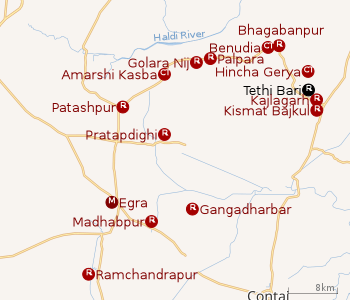 |
| Cities and towns in Egra subdivision of Purba Medinipur district M: municipal city/ town, CT: census town, R: rural/ urban centre. Owing to space constraints in the small map, the actual locations in a larger map may vary slightly |
Location
Tethi Bari is located at 22.0373°N 87.8075°E.
Urbanisation
96.96% of the population of Egra subdivision live in the rural areas. Only 3.04% of the population live in the urban areas, and that is the lowest proportion of urban population amongst the four subdivisions in Purba Medinipur district.[1]
Note: The map alongside presents some of the notable locations in the subdivision. All places marked in the map are linked in the larger full screen map.
Demographics
As per 2011 Census of India Tethi Bari had a total population of 2,420 of which 1,259 (52%) were males and 1,161 (48%) were females. Population below 6 years was 268. The total number of literates in Tethi Bari was 2,022 (93.96 % of the population over 6 years).[2]
Transport
Deshapran railway station, located nearby, is on the Tamluk-Digha line, constructed in 2003-04.[3][4]
Education
Bajkul Milani Mahavidyalaya was established at Tethibari mouza, PO Kismat Bajkul, in 1964. It is affiliated to Vidyasagar University.[5]
Healthcare
There is primary health centres at Kajlagarh (with 6 beds).[6]
References
- "District Statistical Handbook 2014 Purba Medinipur". Table 2.2. Department of Planning and Statistics, Government of West Bengal. Retrieved 17 April 2019.
- "2011 Census – Primary Census Abstract Data Tables". West Bengal – District-wise. Registrar General and Census Commissioner, India. Retrieved 23 April 2017.
- "68689 Santragachi-Digha EMU". Time Table. indiarailinfo. Retrieved 30 March 2017.
- "Year of construction of important BG lines" (PDF). History. South Eastern Railway. Retrieved 1 July 2016.
- "Bajkul Milani Mahavidyalaya". BMM. Retrieved 30 March 2017.
- "Health & Family Welfare Department". Health Statistics. Government of West Bengal. Retrieved 27 March 2019.
Cities, towns, locations and neighbourhoods in Purba Medinipur District | |||||||||
|---|---|---|---|---|---|---|---|---|---|
| Cities, municipal and census towns |
| ||||||||
| Locations other than cities and towns |
| ||||||||
| Neighbourhoods |
| ||||||||
| Related topics |
| ||||||||