Ramnagar, Purba Medinipur
Ramnagar is a village, in Ramnagar I CD block in Contai subdivision of Purba Medinipur district in the state of West Bengal, India.
Ramnagar | |
|---|---|
Village | |
 Ramnagar Location in West Bengal, India  Ramnagar Ramnagar (India) | |
| Coordinates: 21°40′43.0″N 87°33′33.1″E | |
| Country | |
| State | West Bengal |
| District | Purba Medinipur |
| Population (2011) | |
| • Total | 1,914 |
| Languages | |
| • Official | Bengali, English |
| Time zone | UTC+5:30 (IST) |
| PIN | 721441 (Ramnagar) |
| Telephone/STD code | 03229 |
| Lok Sabha constituency | Kanthi |
| Vidhan Sabha constituency | Ramnagar |
| Website | purbamedinipur |
Geography
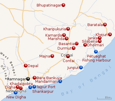 |
| Cities and towns in Contai subdivision of Purba Medinipur district M: municipal city/ town, CT: census town, R: rural/ urban centre, S: port, sea-beach Owing to space constraints in the small map, the actual locations in a larger map may vary slightly |
CD block HQ
The headquarters of Ramnagar I CD block are located at Ramnagar.[1]
Police station
Ramnagar police station is located at Talgachari. It has jurisdiction over Ramnagar I (part) and Ramnagar II CD blocks. It covers an area of 286.02 km2 with a population of 309,836.[2]
Urbanisation
93.55% of the population of Contai subdivision live in the rural areas. Only 6.45% of the population live in the urban areas and it is considerably behind Haldia subdivision in urbanization, where 20.81% of the population live in urban areas.[3]
Note: The map alongside presents some of the notable locations in the subdivision. All places marked in the map are linked in the larger full screen map.
Demographics
As per 2011 Census of India Ramnagar had a total population of 1,914 of which 964 (50%) were males and 950 (50%) were females. Population below 6 years was 196. The total number of literates in Ramnagar was 1,580 (91.97% of the population over 6 years).[4]
Transport
SH 4 connecting Jhalda (in Purulia district) and Digha (in Purba Medinipur district) passes through Ramnagar.[5] Egra-Ramnagar Road meets SH 4 at Ramnagar.[6]
Howrah–Kharagpur line | |||||||||||||||||||||||||||||||||||||||||||||||||||||||||||||||||||||||||||||||||||||||||||||||||||||||||||||||||||||||||||||||||||||||||||||||||||||||||||||||||||||||||||||||||||||||||||||||||||||||||||||||||||||||||||||||||||||||||||||||||||||||||||||||||||||||||||||||||||||||||||||||||||||||||||||||||||||||||||||||||||||||||||||||||||||||||||||||||||||||||||||||||||||||||||||||||||||||||||||||||||||||||||||||||||||||||||||||||||||||||||||||||||||||||||||||||||||||||||||||||||||||||||||||||||||||||||||||||||||||||||||||||||||||||||||||||||||||||||||||||||||||||||||||||||||||||||||||||||||||||||||||||||
|---|---|---|---|---|---|---|---|---|---|---|---|---|---|---|---|---|---|---|---|---|---|---|---|---|---|---|---|---|---|---|---|---|---|---|---|---|---|---|---|---|---|---|---|---|---|---|---|---|---|---|---|---|---|---|---|---|---|---|---|---|---|---|---|---|---|---|---|---|---|---|---|---|---|---|---|---|---|---|---|---|---|---|---|---|---|---|---|---|---|---|---|---|---|---|---|---|---|---|---|---|---|---|---|---|---|---|---|---|---|---|---|---|---|---|---|---|---|---|---|---|---|---|---|---|---|---|---|---|---|---|---|---|---|---|---|---|---|---|---|---|---|---|---|---|---|---|---|---|---|---|---|---|---|---|---|---|---|---|---|---|---|---|---|---|---|---|---|---|---|---|---|---|---|---|---|---|---|---|---|---|---|---|---|---|---|---|---|---|---|---|---|---|---|---|---|---|---|---|---|---|---|---|---|---|---|---|---|---|---|---|---|---|---|---|---|---|---|---|---|---|---|---|---|---|---|---|---|---|---|---|---|---|---|---|---|---|---|---|---|---|---|---|---|---|---|---|---|---|---|---|---|---|---|---|---|---|---|---|---|---|---|---|---|---|---|---|---|---|---|---|---|---|---|---|---|---|---|---|---|---|---|---|---|---|---|---|---|---|---|---|---|---|---|---|---|---|---|---|---|---|---|---|---|---|---|---|---|---|---|---|---|---|---|---|---|---|---|---|---|---|---|---|---|---|---|---|---|---|---|---|---|---|---|---|---|---|---|---|---|---|---|---|---|---|---|---|---|---|---|---|---|---|---|---|---|---|---|---|---|---|---|---|---|---|---|---|---|---|---|---|---|---|---|---|---|---|---|---|---|---|---|---|---|---|---|---|---|---|---|---|---|---|---|---|---|---|---|---|---|---|---|---|---|---|---|---|---|---|---|---|---|---|---|---|---|---|---|---|---|---|---|---|---|---|---|---|---|---|---|---|---|---|---|---|---|---|---|---|---|---|---|---|---|---|---|---|---|---|---|---|---|---|---|---|---|---|---|---|---|---|---|---|---|---|---|---|---|---|---|---|---|---|---|---|---|---|---|---|---|---|---|---|---|---|---|---|---|---|---|---|---|---|---|---|---|---|---|---|---|---|---|---|---|---|---|---|---|---|---|---|---|---|---|---|---|---|---|---|---|---|---|---|---|---|---|---|---|---|---|---|---|---|---|---|---|---|---|---|---|---|---|---|---|---|---|---|---|---|---|---|---|---|---|---|---|---|---|---|---|---|---|---|---|---|---|---|---|---|---|---|---|---|---|---|---|---|---|---|---|---|---|---|---|---|---|---|---|---|---|---|---|---|---|---|---|---|---|---|---|---|---|---|---|---|---|---|---|---|---|---|---|
| |||||||||||||||||||||||||||||||||||||||||||||||||||||||||||||||||||||||||||||||||||||||||||||||||||||||||||||||||||||||||||||||||||||||||||||||||||||||||||||||||||||||||||||||||||||||||||||||||||||||||||||||||||||||||||||||||||||||||||||||||||||||||||||||||||||||||||||||||||||||||||||||||||||||||||||||||||||||||||||||||||||||||||||||||||||||||||||||||||||||||||||||||||||||||||||||||||||||||||||||||||||||||||||||||||||||||||||||||||||||||||||||||||||||||||||||||||||||||||||||||||||||||||||||||||||||||||||||||||||||||||||||||||||||||||||||||||||||||||||||||||||||||||||||||||||||||||||||||||||||||||||||||||
| Sources:[7][8][9][10] | |||||||||||||||||||||||||||||||||||||||||||||||||||||||||||||||||||||||||||||||||||||||||||||||||||||||||||||||||||||||||||||||||||||||||||||||||||||||||||||||||||||||||||||||||||||||||||||||||||||||||||||||||||||||||||||||||||||||||||||||||||||||||||||||||||||||||||||||||||||||||||||||||||||||||||||||||||||||||||||||||||||||||||||||||||||||||||||||||||||||||||||||||||||||||||||||||||||||||||||||||||||||||||||||||||||||||||||||||||||||||||||||||||||||||||||||||||||||||||||||||||||||||||||||||||||||||||||||||||||||||||||||||||||||||||||||||||||||||||||||||||||||||||||||||||||||||||||||||||||||||||||||||||
Ramnagar (Bengal) railway station is the nearest railway station on the Tamluk-Digha line,[11]
References
- "District Census Handbook: Purba Medinipur" (PDF). Map of Purba Medinipur with CD block HQs and Police Stations. Directorate of Census Operations, West Bengal, 2011. Retrieved 9 November 2016.
- "Ramnagar PS". Purba Medinipur District Police. Retrieved 10 November 2016.
- "District Statistical Handbook 2014 Purba Medinipur". Table 2.2. Department of Planning and Statistics, Government of West Bengal. Retrieved 22 April 2019.
- "2011 Census – Primary Census Abstract Data Tables". West Bengal – District-wise. Registrar General and Census Commissioner, India. Retrieved 10 November 2016.
- "List of State Highways in West Bengal". West Bengal Traffic Police. Retrieved 10 November 2016.
- Google maps
- Google maps
- Kharagpur-Howrah Local 38606 Indiarailinfo
- Howrah-Haldia Local 68689 ⇒ 38089 Indiarailinfo
- Santragachi-Digha EMU 78001 ⇒ 68687 Indiarailinfo
- "68690 Digha-Mecheda Local". Time Table. indiarailinfo. Retrieved 10 November 2016.
Cities, towns, locations and neighbourhoods in Purba Medinipur District | |||||||||
|---|---|---|---|---|---|---|---|---|---|
| Cities, municipal and census towns |
| ||||||||
| Locations other than cities and towns |
| ||||||||
| Neighbourhoods |
| ||||||||
| Related topics |
| ||||||||