Tarawa
Tarawa is an atoll and the capital of the Republic of Kiribati,[1][2][3] in the central Pacific Ocean. It comprises North Tarawa, which has much in common with other, more remote islands of the Gilberts group; and South Tarawa, which is home to 56,284 people as of 2010 – half of the country's total population.[4][5] The atoll was the site of the Battle of Tarawa during World War II.
.png) Map of South Tarawa (red) and North Tarawa (yellow) within Tarawa Atoll | |
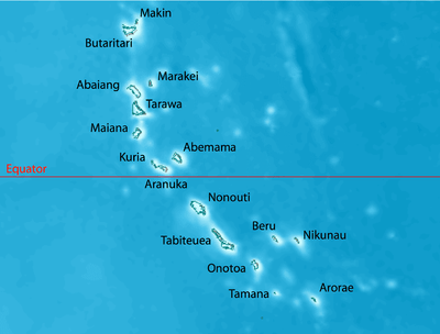 Map of the Gilbert Islands | |
 Tarawa Location in Kiribati | |
| Geography | |
|---|---|
| Location | Pacific Ocean |
| Coordinates | 1°20′N 173°00′E |
| Archipelago | Gilbert Islands |
| Area | 500 km2 (190 sq mi) |
| Highest elevation | 3 m (10 ft) |
| Administration | |
| Demographics | |
| Population | 56,284 (2010) |
Geography
Tarawa has a large lagoon, 500 square kilometres (193 square miles) in total area, and a wide reef. Although naturally abundant in fish and shellfish of all kinds, marine resources are being strained by the large and growing population. Drought is frequent, but in normal years rainfall is sufficient to maintain breadfruit, papaya and banana trees as well as coconut and pandanus.
North Tarawa consists of a string of islets from Buariki in the north to Buota in the south. The islets are separated in places by wide channels that are best crossed at low tide, and there is a ferry service between Buota and Abatao.[6] Only Buota is connected by road to South Tarawa, via a bridge.
On South Tarawa, the construction of causeways has now created a single strip of land from Betio in the west to Tanaea in the northeast.[7]
Climate
Tarawa features a tropical rainforest climate under the Köppen climate classification. The climate is pleasant from April to October, with predominant northeastern winds and stable temperatures close to 30 °C (86 °F). From November to March, western gales bring rain and occasional cyclones.[2][8][9]
Precipitation varies significantly between islands. For example, the annual average is 3,000 mm (120 in) in the north and 500 mm (20 in) in the south of the Gilbert Islands.[8] Most of these islands are in the dry belt of the equatorial oceanic climatic zone and experience prolonged droughts.[9]
| Climate data for Tarawa Airport (South Tarawa) | |||||||||||||
|---|---|---|---|---|---|---|---|---|---|---|---|---|---|
| Month | Jan | Feb | Mar | Apr | May | Jun | Jul | Aug | Sep | Oct | Nov | Dec | Year |
| Record high °C (°F) | 35.0 (95.0) |
33.0 (91.4) |
35.0 (95.0) |
34.5 (94.1) |
34.5 (94.1) |
33.5 (92.3) |
34.5 (94.1) |
34.5 (94.1) |
34.5 (94.1) |
35.0 (95.0) |
35.0 (95.0) |
35.0 (95.0) |
35.0 (95.0) |
| Average high °C (°F) | 30.7 (87.3) |
30.6 (87.1) |
30.7 (87.3) |
30.7 (87.3) |
30.8 (87.4) |
30.8 (87.4) |
30.9 (87.6) |
31.0 (87.8) |
31.1 (88.0) |
31.2 (88.2) |
31.3 (88.3) |
30.9 (87.6) |
30.9 (87.6) |
| Daily mean °C (°F) | 28.2 (82.8) |
28.1 (82.6) |
28.1 (82.6) |
28.2 (82.8) |
28.4 (83.1) |
28.3 (82.9) |
28.2 (82.8) |
28.3 (82.9) |
28.4 (83.1) |
28.6 (83.5) |
28.5 (83.3) |
28.2 (82.8) |
28.3 (82.9) |
| Average low °C (°F) | 25.3 (77.5) |
25.3 (77.5) |
25.2 (77.4) |
25.3 (77.5) |
25.5 (77.9) |
25.3 (77.5) |
25.1 (77.2) |
25.2 (77.4) |
25.3 (77.5) |
25.4 (77.7) |
25.4 (77.7) |
25.3 (77.5) |
25.3 (77.5) |
| Record low °C (°F) | 21.5 (70.7) |
22.5 (72.5) |
22.5 (72.5) |
22.5 (72.5) |
21.0 (69.8) |
21.0 (69.8) |
21.0 (69.8) |
21.5 (70.7) |
22.5 (72.5) |
22.0 (71.6) |
22.5 (72.5) |
22.0 (71.6) |
21.0 (69.8) |
| Average precipitation mm (inches) | 271 (10.7) |
218 (8.6) |
204 (8.0) |
184 (7.2) |
158 (6.2) |
155 (6.1) |
168 (6.6) |
138 (5.4) |
120 (4.7) |
110 (4.3) |
115 (4.5) |
212 (8.3) |
2,052 (80.8) |
| Average precipitation days (≥ 0.3 mm) | 15 | 12 | 14 | 15 | 15 | 14 | 16 | 18 | 15 | 11 | 10 | 17 | 172 |
| Average relative humidity (%) | 81 | 80 | 81 | 82 | 81 | 81 | 80 | 79 | 77 | 77 | 79 | 81 | 80 |
| Mean monthly sunshine hours | 220.1 | 192.1 | 207.7 | 201.0 | 229.4 | 219.0 | 229.4 | 257.3 | 243.0 | 260.4 | 240.0 | 189.1 | 2,688.5 |
| Mean daily sunshine hours | 7.1 | 6.8 | 6.7 | 6.7 | 7.4 | 7.3 | 7.4 | 8.3 | 8.1 | 8.4 | 8.0 | 6.1 | 7.4 |
| Source: Deutscher Wetterdienst[10] | |||||||||||||
Administration
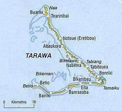
Tarawa atoll has three administrative subdivisions: Betio Town Council (or BTC), on Betio Islet; Teinainano Urban Council (or TUC), from Bairiki to Tanaea; and Eutan Tarawa Council (or ETC), for North Tarawa or Tarawa Ieta, consisting of all the islets on the east side from Buota northwards.[11] The meaning of Teinainano is "down of the mast", alluding to the sail-shape of the atoll.
South Tarawa hosts the capital of the Republic of Kiribati. The House of Assembly is in Ambo, and the State House is in Bairiki. The offices of the various ministries of the government range from Betio at the south-west extreme to Nawerewere (at the near-centre of North Tarawa in an easterly island in its chain). Settlements on North Tarawa include Marenanuka and Taborio.
Diplomatic missions
Four resident diplomatic missions exist: the embassies of China and Cuba, and the high commissions of Australia and New Zealand.
History

In Kiribati mythology, Tarawa was the earth when the land, ocean and sky had not been cleaved yet by Nareau the spider. Thus after calling the sky karawa and the ocean marawa, he called the piece of rock that Riiki (another god that Nareau found) had stood upon when he lifted up the sky as, Tarawa. Nareau then created the rest of the islands in Kiribati and also Samoa.
People arrived on these islands thousands of years ago, and there have been migrations to and from Kiribati since antiquity.[12]
Evidence from a range of sources, including carbon dating and DNA analyses, confirms that the exploration of the Pacific included settlement of the Gilbert Islands by around 200 BC. The people of Kiribati are still excellent seafarers, capable of making ocean crossings in locally made vessels using traditional navigation techniques.[13]
Thomas Gilbert, captain of the East India Company vessel Charlotte, was the first European to describe Tarawa, arriving on 20 June 1788. He named it Matthew Island, after the owner of his ship Charlotte. He named the lagoon, Charlotte Bay.[14] Gilbert's 1788 sketches survive.
The island was surveyed in 1841 by the US Exploring Expedition.[15]
Tarawa Post Office opened on 1 January 1911.[16]
Sir Arthur Grimble was a cadet administrative officer based at Tarawa (1913–1919)[17] and became Resident Commissioner of the Gilbert and Ellice Islands colony in 1926.[18]
During World War II, Tarawa was occupied by the Japanese, and beginning on 20 November 1943 it was the scene of the bloody Battle of Tarawa. On that day United States Marines landed on Tarawa and fought Japanese soldiers occupying entrenched positions on the atoll. The Marines captured the island after 76 hours of intense fighting that killed 6,000 people on both sides.
The fierce fighting was the subject of a documentary film produced by the Combat Photographers of the Second Marine Division entitled With the Marines at Tarawa. It was released in March 1944 at the insistence of President Roosevelt. It became the first time many Americans viewed American servicemen dead on film.
The Kiribati Government commenced a road restoration project funded in part by the World Bank in 2014 to surface the main road between Betio in the West to Bonriki in the East,[19] upgrading the main road that transits Tarawa from a dirt road. As of 2018, all that remained to be completed of this project was the sealing of Betio Causeway, connecting Bairiki and Betio.
Literature
- A Pattern of Islands by Sir Arthur Grimble, John Murray & Co, London, 1952; republished 2011 by Eland, London, ISBN 978-1-906011-45-1
- Return to the Islands by Sir Arthur Grimble, John Murray & Co, London, 1957
In popular culture
- Tarawa is the site of the 1944 Pulitzer Prize-winning photograph by Frank Filan, depicting a destroyed bunker.
- "Tarawa Atoll Sanglant" is a Belgian comic written by Jean-Michel Charlier and Victor Hubinon in 1950. (ISBN 2-8001-2063-0)
- Leon Uris's 1953 fictional Battle Cry extensively depicts the 1943 battle. (Uris was a Marine on Guadalcanal.)
- A 1956 British drama film Pacific Destiny based on the book A Pattern of Islands was made in 1956.
- The 1999 novel Return to Mars by Ben Bova uses Tarawa as the mission control for an expedition to Mars.
- The 2004 book The Sex Lives of Cannibals by J. Maarten Troost is a lighthearted account of the author's two years living on Tarawa.
- The Far Reaches, a 2007 historical novel by Homer Hickam, describes the Battle of Tarawa. (ISBN 0-312-334753)
- Leon Cooper, a US Navy Landing Craft Operator who took part in the WWII battle, returned to the island in 2008 to investigate reports the beach he landed on was littered with garbage. His journey was chronicled in the documentary "Return to Tarawa: The Leon Cooper Story", narrated by Ed Harris.
Memorial
- USS Tarawa was the name of the first LHA-class amphibious assault ship.
Notes
- "Kiribati government website". Government of Kiribati. Archived from the original on 26 June 2010. Retrieved 29 May 2014.
- "Kiribati". The World Factbook. Central Intelligence Agency.
- "European Union – list of countries in the world".
- Country files at earth-info.nga.mil Archived 12 August 2005 at the Wayback Machine
- "Kiribati Census Report 2010 Volume 1" (PDF). National Statistics Office, Ministry of Finance and Economic Development, Government of Kiribati. Archived from the original (PDF) on 30 September 2013. Retrieved 17 March 2013.
- "North Tarawa Island Report 2012". Government of Kiribati.
- "South Tarawa Island Report 2012". Government of Kiribati.
- Kiribati. Encyclopædia Britannica
- Thomas, 3
- "Klimatafel von Tarawa, Int. Flugh. Bonriki / Kiribati (Gilbert-Inseln)" (PDF). Baseline climate means (1961–1990) from stations all over the world (in German). Deutscher Wetterdienst. Archived from the original (PDF) on 29 September 2019. Retrieved 29 September 2019.
- Dr Temakei Tebano & others (March 2008). "Island/atoll climate change profiles – Tarawaieta (North Tawara)". Office of Te Beretitent – Republic of Kiribati Island Report Series (for KAP II (Phase 2). Archived from the original on 6 November 2011. Retrieved 28 April 2015.
- North Tarawa Socioeconomic Report 2008. Secretariat of the Pacific Community and Government of Kiribati
- Howe, K. R. (2006). Vaka Moana – voyages of the ancestors. David Bateman. ISBN 1869536258.
- Samuel Eliot Morison (22 May 1944). "The Gilberts & Marshalls: A distinguished historian recalls the past of two recently captured pacific groups". Life magazine. Retrieved 14 October 2009.
Being now abreast of this island, the extremity ending in a beautiful clump of trees, I hauled up to look at the bay. It appeared to be safe and commodious, sheltered by a long reef running parallel with the island, with two large inlets into the bay. The reef is about ¾ of a mile from the beach, and has several small islands which appear like flower pots.
- Stanton, William (1975). The Great United States Exploring Expedition. Berkeley: University of California Press. pp. 245. ISBN 0520025571.
- Premier Postal History. "Post Office List". Premier Postal Auctions. Retrieved 5 July 2013.
- Grimble, Sir Arthur (1952). "A Pattern of Islands". Early New Zealand Books (NZETC). Retrieved 16 October 2011.
- Grimble, Sir Arthur. A Pattern of Islands. John Murray & Co, London, 1952; republished 2011 by Eland, London. ISBN 978-1-906011-45-1.
- http://www.worldbank.org/projects/P122151/kiribati-road-rehabilitation-project?lang=en
External links
| Wikimedia Commons has media related to Tarawa. |
- Tarawa on The Web – A History of the Bloodiest Battle
- The Marine Assault of Tarawa
- Tarawa the Aftermath
- "Tarawa" the USCG cat
- Exhibit: The Alfred Agate Collection: The United States Exploring Expedition, 1838–1842 from the Navy Art Gallery
- Return to Tawara
| Gilbert Islands |  | |
|---|---|---|
| Phoenix Islands | ||
| Line Islands | ||
| West of Gilberts | ||
| Reefs | ||
| ||
| Authority control |
|
|---|