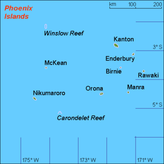
Carondelet Reef
Carondelet Reef is a horseshoe-shaped reef of the Phoenix Islands, also known as the Rawaki Islands, in the Republic of Kiribati. It is located 106 km southeast of Nikumaroro, at 05°34′S 173°51′W, and has a least depth of 1.8 meters. It is reported to be approximately 1.5 km in length.[1] The sea occasionally breaks over it.
| Carondelet Reef | |
|---|---|
 Location of Phoenix Islands | |
| Summit depth | 1.8 metres |
| Location | |
| Location | central Pacific Ocean |
| Group | Phoenix Islands |
| Coordinates | 05°34′S 173°51′W |
| Country | Kiribati |
| Geology | |
| Type | Reef |
| History | |
| Discovery date | August 31, 1898 |
| Discovered by | Capt. Wilder F. Stetson |
History and Name
During his voyage from Puget Sound to Australia, Captain Wilder Farley Stetson (1849-1924) of the ship Carondelet sighted a reef on August 31, 1898 from position 5° 35′ S, 173° 58′ W. He was within two miles of it and considered it very dangerous. He “called it Carondelet Reef”. Most likely this wasn't the first time it was viewed by a Westerner, for on authority of admiral Adam Johann von Krusenstern, a discovery in the year 1824 of a reef in position 5° 38′ S, 172° 54′ W. (of Greenwich) had already been claimed by a captain Kemin (of unknown ship). It may have been seen next by Capt. Obed Starbuck of the Nantucket whaler Loper on February 19, 1826, as he saw a "reef of rocks" in the reported position of 5° 29′ S, 175° 01′ W. that day.[2][3][4]
The multiple positions of Winslow Reef, mentioned by Robert Louis Stevenson, may have been due to confusing the position of Carondelet Reef with Winslow Reef.
Status
The reef is part of the Phoenix Islands Protected Area as an underwater nature reserve.
References
- Mike Pearson; Jonathan Willis-Richards. "Islands of Kiribati". Archived from the original on 2006-12-31. Retrieved 2007-02-21.
- "page 7". The San Francisco Call. March 13, 1899.
- Dehner, First (2019). THE ARMCHAIR NAVIGATOR I: Supplements to Post-Spanish Discoveries in The Pacific. Bad Tattoo Inc. pp. 24–25.
- von Kruzenštern, Adam Johann (1827). Recueil de mémoires hydrographiques, pour servir d'analyse et d'explication à l'Atlas de l'océan Pacifique, Volume 2. p. 430.
External links
- Phoenix Islands Protected Area, Kiribati
- Oceandots at the Wayback Machine (archived December 23, 2010)
| Gilbert Islands |  | |
|---|---|---|
| Phoenix Islands | ||
| Line Islands | ||
| West of Gilberts | ||
| Reefs | ||
| ||