Tabuaeran
Tabuaeran or Tahanea, known in English as Fanning Atoll (both Gilbertese and English names are recognised), is an atoll that is part of the Line Islands of the central Pacific Ocean and part of Kiribati. The land area is 33.73 square kilometres (13.02 square miles), and the population in 2010 was 1,960.[1] The maximum elevation is about 3 m (10 ft) above high tide.
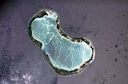 NASA image of Tabuaeran in 2006 | |
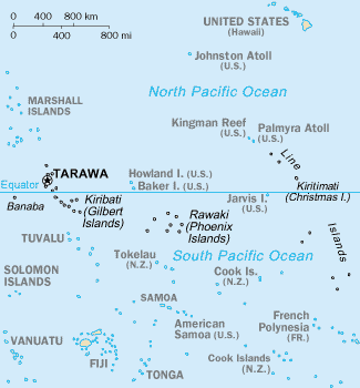
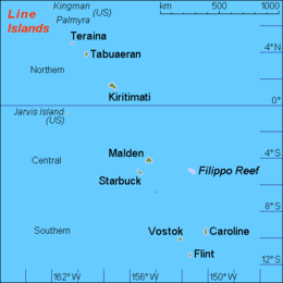 Map of the Line Islands | |
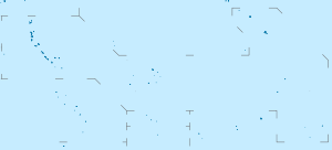 Tabuaeran Map of the Line Islands 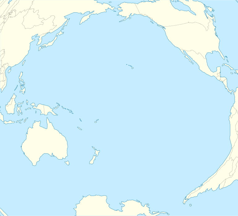 Tabuaeran Tabuaeran (Pacific Ocean) | |
| Geography | |
|---|---|
| Location | North Pacific Ocean |
| Coordinates | 3°51′36″N 159°21′52″W |
| Archipelago | Line Islands |
| Area | 13.02 sq mi (33.7 km2) |
| Highest elevation | 10 ft (3 m) |
| Administration | |
| Demographics | |
| Population | 1,960 (2010) |

The lagoon has an area of 110 square kilometres (42 square miles). The deepest water in the lagoon is about 15 metres (49 feet), but most of it is very shallow.[1]
History
At some 900 miles (1,400 kilometres) distant, Tabuaeran is one of the closest landfalls to the Hawaiian Islands. The atoll was possibly used as a stopover by the Polynesians who first settled Hawaiʻi. Artifacts have been discovered that indicate possible early settlements by people from Polynesia—probably the Cook Islands or Tonga.
The first European to sight Tabuaeran was American captain Edmund Fanning of the American ship Betsy on June 11, 1798; it was named for him.[2] At the time, the atoll was uninhabited and, like all of the Line Islands, had no truly native population. After Fanning, it was visited by whalers of several nationalities. The whaler Harriet had wrecked there in late 1831 or early 1832.
Before 1855, Captain Henry English and 150 labourers from Manihiki settled, and began producing coconut oil for export. He put the island under British protection when Captain W.H.Morshead arrived on HMS Dido on 16 October 1855.
Captain William Wiseman of HMS Caroline formally annexed Fanning to Great Britain on 15 March 1888.
A deep opening, thereafter called the English Channel, was blasted on the west side of the atoll. Tabuaeran hosted a station on the Canada to Australia section of the All Red Line telegraph cable system, beginning in 1902. Fanning Island Post Office opened on 29 November 1902.[3] In September 1914 (World War I), the cable station was visited by the German cruiser SMS Nürnberg and was severely damaged when a landing force went ashore to put the station out of action.[4][5] In 1939 the atoll was incorporated into the British colony of the Gilbert and Ellice Islands. In 1979, it gained independence, becoming part of the Republic of Kiribati.
Tabuaeran features in John Updike's short story "The Blessed Man of Boston, My Grandmother's Thimble, and Fanning Island."
An airfield was constructed on Napari (Napali) islet when the University of Hawaii operated a tide monitoring station on the atoll. The station closed in 1981 and the airfield is no longer in use.[1]
Present
The administrative centre of the atoll is Paelau, on the west side.
Tabuaeran had a population of 1,960 at the 2010 census,[1] principally Gilbertese settlers brought from the main Kiribati archipelago by Fanning Island Plantations, Ltd., to work in the copra industry.
The population declined from 2,539 at the 2005 census following the closure of the secondary school (since reopened), cessation of visits by Norwegian Cruise Line (NCL), and reduced operations by Atoll Seaweed Company.[1]
Eight villages are listed in the 2010 census:
| No. | Village | Population (2005 Census) | Population (2010 Census) |
|---|---|---|---|
| 1 | Napari (Napali) | 194 | 0 |
| 2 | Tereitaki | 438 | 346 |
| 3 | Betania | 260 | 175 |
| 4 | Paelau (Napia, English Harbour) | 250 | 200 |
| 5 | Aontenaa (Aontena) | 177 | 190 |
| 6 | Tenenebo (Terine) | 461 | 453 |
| 7 | Tereitannano (Tereitaki) | 249 | 168 |
| 8 | Aramari | 358 | 244 |
| 9 | Mwanuku (Manuku or Eten) | 152 | 184 |
| Tabuaeran | 2,539 | 1,960 |
The main diet is imported rice and tinned meats, supplemented by local foods: reef fish and shellfish, babai (Cyrtosperma chamissonis), coconut, pigs, chickens, and seaweed (limu).[1]
Major exports are copra and hand crafts (including cowrie shell, shark tooth knives, and Kiribati stamps). An Australian supply ship calls two or three times a year. The sailing vessel Kwai also stops on the island.[6]
The main health centre is located at Paelau in the west, with additional clinics on Napari (Napali) islet in the north and Kimarimari in the south.[1] Helpful organizations with concerns for the local schools, churches and healthcare needs are Pacific CARE Missions and Pacific Island Aid.
Ecology
Overfishing and pollution have impacted on the ocean surrounding the island. In the ocean surrounding uninhabited islands of the Northern Line Islands, sharks comprised 74% of the top predator biomass (329 g m-2) at Kingman Reef and 57% at Palmyra Atoll (97 g m-2), whereas low shark numbers have been observed at Tabuaeran and Kiritimati.[7]
Cruising
Since 2010, the Holland America cruise ships Rotterdam, Westerdam, and Volendam have scheduled visits to Tabuaeran. Seaborne Cruiseline has scheduled visits since 2012. The visits help the island regain income lost since Norwegian Cruise Line ceased weekly visits in 2007.
Until 2007, NCL ships based in Honolulu visited Tabuaeran weekly, partly to avoid U.S. port charges for foreign-flagged ships (see Passenger Vessel Services Act of 1886). NCL ceased visits after introducing US-flagged ships, changing cruise schedules, and eliminating Tabuaeran as a port of call.[8]
Education
The island has three primary schools, one Junior Secondary School, and one Senior Secondary School, Meleangi Tabai High School.[1] The government has previously sought to re-open the high school campus on Kiritimati. [9]
References
- "21. Tabuaeran" (PDF). Office of Te Beretitent - Republic of Kiribati Island Report Series. 2012. Retrieved 28 April 2015.
- Bryan, E.H. American Polynesia and the Hawaiian Chain. Honolulu, Hawaii: Tongg Publishing Company, 1941 pages 141-144.
- Premier Postal History. "Post Office List". Premier Postal Auctions. Retrieved 5 July 2013.
- Barty-King, Girdle Around the World
- R Bruce Scott: Gentlemen on Imperial Service
- SAILING SHIP KWAI
- Stuart A. Sandin; et al. (27 February 2008). "Baselines and Degradation of Coral Reefs in the Northern Line Islands". 3 (2) PLoS ONE. Retrieved 27 January 2017.
- NCL Announces Jade, Jewel And Gem For Largest Ever European Deployment
- "VSA Assignment Description Assignment title English Language Trainer (of Trainers/ Teachers) Country Kiribati." Volunteer Service Abroad (Te Tūao Tāwāhi). Retrieved on 6 July 2018. p. 7.
External links
- Map of Tabuaeran
- Fanning Island on Jane Resture's Oceania Home Page A strong resource including geography, history, photos, and links.
- Fanning-Island.com
- Ancient Polynesian remains
- Atoll Institute, proposed Field Station
- Edmund Fanning in Explorers of the Pacific by Buck (eText)
- 'Paradise Found?' An account of a tourist visit to Fanning Island
| Gilbert Islands |  | |
|---|---|---|
| Phoenix Islands | ||
| Line Islands | ||
| West of Gilberts | ||
| Reefs | ||
| ||