Taliabu Island Regency
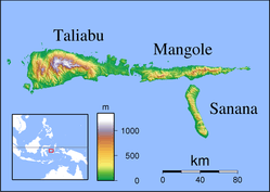
Taliabu Island Regency (Indonesian: Kabupaten Pulau Taliabu) is a regency in the North Maluku province of Indonesia. It was formerly part of the Sula Islands Regency, but in 2013 it was administratively separated to form a separate regency. It is located to the west of Mangole Island and Sanana Island, the two islands which remain part of the Sula Islands Regency.
Taliabu Island Regency Kabupaten Pulau Taliabu | |
|---|---|
 Students seen playing volleyball at the local school | |
 Seal | |
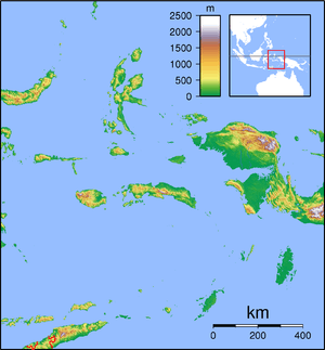
 Location within Maluku Islands | |
| Coordinates: 1.8°S 124.8°E | |
| Country | |
| Province | |
| Capital | Bobong |
| Government | |
| • Regent | Aliong Mus |
| • Vice Regent | Ramli |
| Area | |
| • Total | 1,154.66 sq mi (2,990.55 km2) |
| Population (2010 Census) | |
| • Total | 47,309 |
| • Density | 41/sq mi (16/km2) |
| Time zone | UTC+9 (IEST) |
| Area code | (+62) 921 |
| Website | taliabukab |

Administration
In 2013 the seven districts (kecamatan) on Taliabu Island (and its offshore islets) were split off from the Sula Islands Regency to create a separate Taliabu Island Regency (Kabupaten Pulau Taliabu); they are tabulated below with their areas and their 2010 Census populations.
| Name | English name | Area in km2 | Population Census 2010 |
|---|---|---|---|
| Taliabu Barat Laut | Northwest Taliabu | 172.04 | 4,079 |
| Lede | 193.93 | 5,977 | |
| Taliabu Utara | North Taliabu | 792.43 | 10,880 |
| Taliabu Timur | East Taliabu | 377.37 | 3,542 |
| Taliabu Timur Selatan | Southwest Taliabu | 429.69 | 5,066 |
| Taliabu Selatan | South Taliabu | 469.28 | 8,738 |
| Taliabu Barat | West Taliabu | 4,079 | 9,027 |
| Taliabu Island Regency | 2,990.55 | 47,309 |
References
External links
| Wikimedia Commons has media related to Taliabu Island Regency. |
Regencies and cities of North Maluku | ||
|---|---|---|
Capital: Sofifi | ||
| Regencies | ||
| Cities | ||
This article is issued from Wikipedia. The text is licensed under Creative Commons - Attribution - Sharealike. Additional terms may apply for the media files.