Takht-i-Bahi
Takht-i-Bahi (Urdu: تختِ باہی; "Throne of the water spring"), commonly mispronounced as Takht-i-Bhai (Urdu: تخت بھائی; "Brother's throne"), is an Indo-Parthian archaeological site of an ancient Buddhist monastery in Mardan, Khyber-Pakhtunkhwa, Pakistan. The site is considered among the most imposing relics of Buddhism in all of Gandhara,[1] and has been "exceptionally well-preserved."[1]
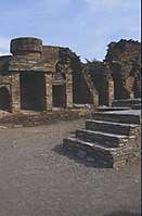
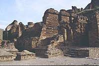
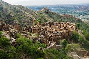 A view of the site's main cluster of ruins | |
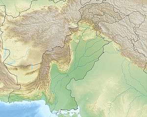 Shown within Pakistan  Takht-i-Bahi (Gandhara)  Takht-i-Bahi (Khyber Pakhtunkhwa) | |
| Location | Mardan, Khyber Pakhtunkhwa, Pakistan |
|---|---|
| Coordinates | 34°17′10″N 71°56′48″E |
| Type | Settlement |
| History | |
| Founded | 1st century CE |
| Abandoned | 7th century CE |
| Official name | Buddhist Ruins of Takht-i-Bahi and Neighbouring City Remains at Sahr-i-Bahlol |
| Type | Cultural |
| Criteria | iv |
| Designated | 1980 (4th session) |
| Reference no. | 140 |
| Region | Asia-Pacific |
The Buddhist monastery was founded in the 1st century CE,[2] and was in use until the 7th century.[1] The complex is regarded by archaeologists as being particularly representative of the architecture of Buddhist monastic centers from its era.[3] Takht-i-Bahi was listed as a UNESCO World Heritage Site in 1980.[2][4]
Etymology
The word Takht-i-Bahi may have different explanations. Local believes that site got its name from two wells on the hill or the springs nearby. In Persian, Takht means "top" or "throne" while bahi means "spring" or "water". When combined together its meaning is Spring from the Top or High Spring, and there were two springs on the top of mountains. Another meaning suggested is Throne of Origin.[4]
Location
The ruins are located about 15 kilometers from Mardan in Pakistan's Khyber-Pakhtunkhwa Province.[2] A small fortified city, dating from the same era, sits nearby.[1] The ruins also sit near a modern village known by the same name.[5] It is located around 500 feet atop the small hill and around 2 km from village bazar.[4] The surrounding area is famous for sugar cane, wheat, maize, vegetable, and orchard cultivation. Once remote and little visited, the site now has a road and car park, set some way below the ruins, and has become popular with visitors.
Structure
There are four main areas of the Takht Bahi complex:
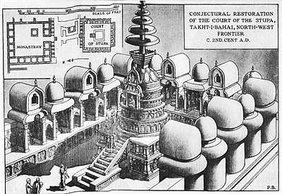
- The Stupa Court, a cluster of stupas located in a central courtyard.[3]
- The monastic chambers, consisting of individual cells arranged around a courtyard, assembly halls, and a dining area.[3]
- A temple complex, consisting of stupas and similar to the Stupa Court, but of later construction.[3]
- The Tantric monastic complex, which consists of small, dark cells with low openings, which may have been used for certain forms of Tantric meditation.[3]
Additional structures on the site may have served as residences or meeting halls, or for secular purposes.[5] All of the buildings on the site are constructed from local stone, and are mortared with lime and mud.[5]
History
Archaeologists have divided the history of the complex into four periods, beginning in the 1st century BCE.[5]
The monastic complex was likely founded in the early 1st century CE.[1] It is proven by an inscriptions found bearing the name of Gondophares (20-46 CE).[4] After Gondophares, the place fell under control of Kujula Kadphises,[4] the first Kushan king. This first era continued until the 2nd century CE, and is associated with another Kushan king Kanishka, as well as early Parthian and later Kushan kings.[5] The second construction period, which included the creation of the Stupa Court and assembly hall, took place during the 3rd and 4th centuries CE. A third construction period, associated with the later Kushan dynasty and the Kidara Kushana rulers, occurred during the 4th and 5th centuries.
The region was runover by Huns in middle of fifth century C.E. which ended the Kushan rule there. The Hun Toramana and then his son Mihirakula unleashed genocide of the populace of Gandhara and a wholesale destruction of Buddhist monastries. The Buddhist monastery of Takht-i-Bahi seems to have been destroyed in the same period of carnage by Huns.[6]
The complex nonetheless was in use until 7th century CE[4].
The first modern historical reference to these ruins was made in 1836 by the French Officer, the Buddhist remains are in a village named Mazdoorabad.[5] Explorations and excavations on this site began in 1864.[5] A significant number of objects from the site can be found in the British Museum.[7] The site underwent a major restoration in the 1920s.[3]
Archaeological remains


Works of art
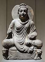
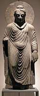 Statue of the Buddha, Takht-i-Bahi, 2nd-3rd century CE. Schist, H. 98 cm. Museum für Indische Kunst.
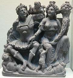
 The Buddha on lion throne. Takht-i-Bahi. Schist, H. 52.5 cm. Museum für Indische Kunst.
%2C_150-200_dc_ca.jpg) Shakyamuni, 150-200 AD, Cleveland Museum of Art, perhaps from Takht-i-Bahi
Shakyamuni, 150-200 AD, Cleveland Museum of Art, perhaps from Takht-i-Bahi
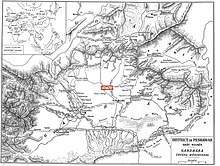
Nearby localities
The villages of Thordher (Old name Said Ghani Kalae), Ghafe, Lund Khwar, Sher Garh, Saroo Shah, Sehri-Bahlol, Pathai, Mazdoorabad, Fazl-e-abad, Gangai, Hathian, Jalala, Pirsaddi, Takkar and Mashal Khan Kalai are other historical places in the vicinity of Takht-Bhai. The most historical location in the era is Sehri Bahlol. This Buddhist monastery is situated on Malakand Road.
The word "Sehri-Bahlol" has been explained by various people in different ways. Local people claim that this is a Hindko word meaning "Sir Bahlol", a prominent political and religious leader of the area. However, the name is not as old as the village of Sehri-Bahlol.
Meager economic conditions, poor educational facilities, and the nefarious effect of dealers of antiquities often result in severe hazard for the proper preservation of archaeological heritage in minor, less controlled sites.
See also
Part of a series on the |
|---|
| History of Pakistan |
 |
| Timeline |
|
Ancient
|
|
Classical
|
|
Medieval
|
|
Early modern
|
|
Modern
|
|
History of provinces |
|
- List of UNESCO World Heritage Sites in Pakistan
- List of museums in Pakistan
- Ranigat (Another historic site in Buner)
References
- UNESCO Descrtiption
- Takht-i-Bahi, UNESCO Office, Islamabad, Pakistan, 2002
- UNESCO Advisory Body Evaluation of Takht Bhai
- Khaliq, Fazal (1 June 2015). "Takht-i-Bhai: A Buddhist monastery in Mardan". DAWN.COM. Retrieved 8 November 2015.
- UNESCO Periodic Report
- Short Guide To Takht-i-bahi by Shakur, M.a.
- British Museum Collection
External links
| Wikimedia Commons has media related to Takht-i-Bahi Buddhist ruins. |
- Buddhist Ruins of Takht-i-Bahi and Neighbouring City Remains at Sahr-i-Bahlol - UNESCO World Heritage List
- UNESCO Periodic Report Summary - Includes a map of the complex.
- Map of Gandhara archeological sites, from the Huntington Collection, Ohio State University (large file)
| Heritage sites |
|  |
|---|---|---|
| Tentative sites |
| |