Ta Veaeng District
Ta Veaeng (Khmer: តាវែង) (also transliterated Ta Veng or Ta Veang) is a district located in Ratanakiri Province, in north-east Cambodia. It is the northernmost district in Cambodia, protruding between Laos and Vietnam.
Ta Veaeng តាវែង | |
|---|---|
District | |
 location in Ratanakiri Province | |
 Ta Veaeng location in Ratanakiri Province | |
| Coordinates: 14°17′31″N 107°14′25″E | |
| Country | |
| Province | Ratanakiri Province |
| Population (1998) | |
| • Total | 2,399 |
| Time zone | UTC+7 (GMT + 7) |
| Geocode | 1408 |
Communes
Ta Veaeng Leu
Ta Veaeng Leu (Khmer: តាវែងលើ) contains ten villages and has a population of 2,399.[1] In the 2007 commune council elections, all five seats for Ta Veaeng Leu went to members of the Cambodian People's Party.[2] Land alienation is a problem of moderate severity in Ta Veaeng Leu.[3] (See Ratanakiri Province for background information on land alienation.)
| Village[1][4] | Population[1] (1998) | Sex ratio[1] (male/female) (1998) | Number of households[1] (1998) | Notes |
|---|---|---|---|---|
| Chan | 145 | 0.71 | 32 | |
| Chuoy | 303 | 0.83 | 56 | |
| Ta Bouk | 288 | 0.97 | 53 | |
| Bangket | 232 | 0.98 | 47 | |
| Sanh | 137 | 1.32 | 32 | |
| Ke Kuong | 159 | 0.73 | 25 | |
| Rieng Vinh | 177 | 0.97 | 43 | |
| Phlueu Thum | 185 | 0.93 | 35 | |
| Phlueu Touch | 131 | 0.96 | 29 | |
| Ta Veaeng | 642 | 0.81 | 118 | 14°2′N 107°7′E[5] |
Ta Veaeng Kraom
Ta Veaeng Kraom (Khmer: តាវែងក្រោម) contains ten villages and has a population of 1,926.[1] In the 2007 commune council elections, all five seats for Ta Veaeng Kraom went to members of the Cambodian People's Party.[2] Land alienation is a problem of moderate severity in Ta Veaeng Kraom.[3] (See Ratanakiri Province for background information on land alienation.)
| Village[1][4] | Population[1] (1998) | Sex ratio[1] (male/female) (1998) | Number of households[1] (1998) | Notes |
|---|---|---|---|---|
| Tumpuon Reung Thum | 372 | 1.02 | 69 | |
| Kaoh Pong | 34 | 1.27 | 8 | |
| Sieng Say | 178 | 0.78 | 26 | |
| Pha Yang | 207 | 1.07 | 44 | |
| Keh Kuong Touch | 106 | 1.3 | 19 | |
| Ta Ngach | 102 | 0.82 | 16 | |
| Phav | 480 | 0.85 | 75 | |
| Tumpuon Reung Touch | 156 | 1.14 | 28 | |
| Vieng Chan | 104 | 0.73 | 20 | |
| Tun | 187 | 0.99 | 54 | 13°54′N 107°4′E[5] |
References
- "Final Population Totals, Rotanak Kiri Province, 1998" Archived 2008-10-29 at the Wayback Machine. Cambodia National Institute of Statistics. Accessed June 6, 2008.
- "Official Results of the 2007 Commune Councils Election in Ratank Kiri" Archived 2008-06-02 at the Wayback Machine. [sic] National Election Committee, No 4.58/07 NEC.SG.PIB (April 18, 2007). Accessed June 6, 2008.
- "Land Alienation in Indigenous Minority Communities - Ratanakiri Province, Cambodia" Archived 2008-06-14 at the Wayback Machine. NGO Forum on Cambodia (August 2006). Accessed June 6, 2008.
- "Commune name: Ratanak Kiri (រតនគីរី)" Archived 2008-06-02 at the Wayback Machine. Cambodia National Institute of Statistics. Accessed June 6, 2008.
- National Geospacial-Intelligence Agency
Capital city: Banlung | |||||||||||||||||||
| Landmarks | 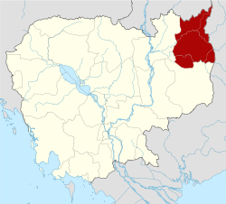 | ||||||||||||||||||
| Administrative divisions |
| ||||||||||||||||||
| Autonomous municipality |
| ||||||||||||||||||||||||||||||||||||||||||||||||||
|---|---|---|---|---|---|---|---|---|---|---|---|---|---|---|---|---|---|---|---|---|---|---|---|---|---|---|---|---|---|---|---|---|---|---|---|---|---|---|---|---|---|---|---|---|---|---|---|---|---|---|---|
| Provinces |
| ||||||||||||||||||||||||||||||||||||||||||||||||||