Kak Commune, Bar Kaev District
Kak (Khmer: កក់) is a commune in Bar Kaev District in northeast Cambodia. It contains six villages and has a population of 1,729.[1] In the 2007 commune council elections, all five of its seats were awarded to members of the Cambodian People's Party.[2] Land alienation has been a major problem in Kak; the indigenous community now owns very little agricultural land.[3] (See Ratanakiri Province for background information on land alienation.)
Kak កក់ | |
|---|---|
 Kak Location within Cambodia | |
| Coordinates: 13.7171°N 107.2353°E | |
| Country | Cambodia |
| Province | Ratanakiri Province |
| District | Bar Kaev |
| Villages | 6 |
| Population (1998) | |
| • Total | 1,729 |
| Time zone | UTC+07 |
| Geocode | 160301 |
Villages
| Village[1][4] | Population[1] (1998) | Sex ratio[1] (male/female) (1998) | Number of households[1] (1998) |
|---|---|---|---|
| Reung Touch | 145 | 1.07 | 28 |
| Sala (also Srala) | 245 | 1.15 | 37 |
| Ka Chak | 347 | 0.92 | 51 |
| Kak | 303 | 0.87 | 52 |
| Yeun | 466 | 1.02 | 74 |
| Chrung | 223 | 0.87 | 36 |
References
- "Archived copy" (PDF). Archived from the original (PDF) on 2008-10-29. Retrieved 2008-06-06.CS1 maint: archived copy as title (link)
- http://www.necelect.org.kh/English/ElectionResult/2007/Official%2520results/24provinces/16%2520Ratanak%2520Kiri.pdf Archived 2008-06-02 at the Wayback Machine
- "Land_Alienation_Update1" (PDF). Archived from the original (PDF) on 2008-06-14.
- "Archived copy". Archived from the original on 2008-06-02. Retrieved 2008-06-06.CS1 maint: archived copy as title (link)
Capital city: Banlung | |||||||||||||||||||
| Landmarks | 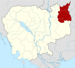 | ||||||||||||||||||
| Administrative divisions |
| ||||||||||||||||||
This article is issued from Wikipedia. The text is licensed under Creative Commons - Attribution - Sharealike. Additional terms may apply for the media files.