Swedesboro, New Jersey
Swedesboro is a borough in Gloucester County, New Jersey, United States. As of the 2010 United States Census, the borough's population was 2,584,[8][9][10] reflecting an increase of 529 (+25.7%) from the 2,055 counted in the 2000 Census, which had in turn increased by 31 (+1.5%) from the 2,024 counted in the 1990 Census.[19]
Swedesboro, New Jersey | |
|---|---|
| Borough of Swedesboro | |
 | |
 Map of Swedesboro highlighted within Gloucester County. Inset: Location of Gloucester County in New Jersey. | |
 Census Bureau map of Swedesboro, New Jersey | |
| Coordinates: 39.745884°N 75.310947°W[1][2] | |
| Country | |
| State | |
| County | |
| Incorporated | April 9, 1902 |
| Government | |
| • Type | Borough |
| • Body | Borough Council |
| • Mayor | Thomas W. Fromm (D, term ends December 31, 2023)[4][5] |
| • Municipal clerk | Lois Elder[6] |
| Area | |
| • Total | 0.758 sq mi (1.964 km2) |
| • Land | 0.724 sq mi (1.876 km2) |
| • Water | 0.034 sq mi (0.088 km2) 4.49% |
| Area rank | 526th of 566 in state 24th of 24 in county[1] |
| Elevation | 46 ft (14 m) |
| Population | |
| • Total | 2,584 |
| • Estimate (2019)[11] | 2,568 |
| • Rank | 467th of 566 in state 22nd of 24 in county[12] |
| • Density | 3,568.4/sq mi (1,377.8/km2) |
| • Density rank | 181st of 566 in state 4th of 24 in county[12] |
| Time zone | UTC−05:00 (Eastern (EST)) |
| • Summer (DST) | UTC−04:00 (Eastern (EDT)) |
| ZIP Code | |
| Area code(s) | 856 Exchanges: 241, 467[15] |
| FIPS code | 3401571850[1][16][17] |
| GNIS feature ID | 0885415[1][18] |
| Website | www |
Swedesboro was formed as a borough by an act of the New Jersey Legislature on April 9, 1902, from portions of Woolwich Township.[20][21] The borough was named for its early settlers from Sweden.[22][23]
Swedesboro has been recognized by the National Arbor Day Foundation as a Tree City USA since 2000.[24]
History
.jpg)
Swedesboro was settled as part of New Sweden around 1650.[25] The early Swedes and Finns were fishermen, hunters and farmers.[26]
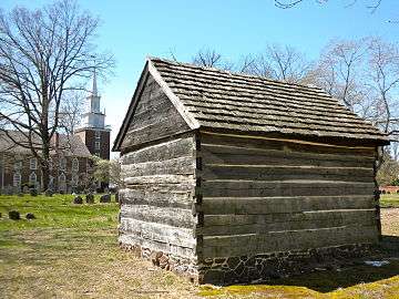
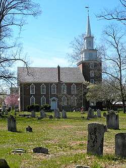
Swedesboro, initially named Sveaborg by the Swedish settlers, along with Bridgeport (Nya Stockholm) and Finns Point (Varkens Kill), was one of only three settlements established in New Jersey as a part of the New Sweden colony. The oldest extant log cabin in the United States, the Nothnagle Log Cabin (ca. 1640) was built by Antti Niilonpoika (Anthony Neilson/Nelson) in Swedesboro.[27] It is listed on the National Register of Historic Places, as is Trinity Episcopal "Old Swedes" Church, which was established as a Swedish Lutheran Church in 1703; the present building dates to 1784.[28]
As a consequence of the Second Northern War, New Sweden passed into Dutch hands in 1655. In 1667, the English subsequently annexed the region along the Delaware River after the Second Anglo-Dutch War. The English Colonial government needed a road between the communities of Burlington and Salem and built the Kings Highway in 1691, which opened the southern portion of Gloucester County to more settlers, who were drawn to the area by the fertile sandy soil, prime farmland and vast tracts of oak, birch, maple and pine trees. Originally, the community was called Raccoon, until the name was changed to Swedesboro in 1765.[29]
Trinity Church Cemetery is the burial place of Governor of New Jersey Charles C. Stratton and Congressman Benjamin Franklin Howey, among other notables.[30]
Through the late 1800s, Raccoon Creek was a water route that was naturally deep enough to transport wood and farm produce to Philadelphia by the Delaware River.
Carl XVI Gustaf, King of Sweden, visited the borough as part of a 1976 tour of the United States.[29]
Geography
According to the United States Census Bureau, Swedesboro borough had a total area of 0.758 square miles (1.964 km2), including 0.724 square miles (1.876 km2) of land and 0.034 square miles (0.088 km2) of water (4.49%).[1][2]
Unincorporated communities, localities and place names located partially or completely within the township include Ivyside.[31]
Swedesboro is an independent municipality surrounded on all sides by Woolwich Township,[32][33][34] making it one of only 21 "doughnut towns" in the state, where one municipality entirely surrounds another.[35]
Demographics
| Historical population | |||
|---|---|---|---|
| Census | Pop. | %± | |
| 1880 | 894 | — | |
| 1890 | 2,035 | 127.6% | |
| 1910 | 1,477 | — | |
| 1920 | 1,838 | 24.4% | |
| 1930 | 2,123 | 15.5% | |
| 1940 | 2,268 | 6.8% | |
| 1950 | 2,459 | 8.4% | |
| 1960 | 2,449 | −0.4% | |
| 1970 | 2,287 | −6.6% | |
| 1980 | 2,031 | −11.2% | |
| 1990 | 2,024 | −0.3% | |
| 2000 | 2,055 | 1.5% | |
| 2010 | 2,584 | 25.7% | |
| Est. 2019 | 2,568 | [11][36] | −0.6% |
| Population sources: 1880-1890[37] 1910-2000[38] 1910-1920[39] 1910[40] 1910-1930[41] 1930-1990[42] 2000[43][44] 2010[8][9][10] | |||
2010 Census
The 2010 United States Census counted 2,584 people, 938 households, and 645.344 families in the borough. The population density was 3,568.4 per square mile (1,377.8/km2). There were 1,004 housing units at an average density of 1,386.5 per square mile (535.3/km2). The racial makeup of the borough was 69.81% (1,804) White, 15.02% (388) Black or African American, 0.58% (15) Native American, 1.35% (35) Asian, 0.08% (2) Pacific Islander, 9.48% (245) from other races, and 3.68% (95) from two or more races. Hispanic or Latino of any race were 17.07% (441) of the population.[8]
The 938 households accounted 36.5% with children under the age of 18 living with them; 45.2% were married couples living together; 17.0% had a female householder with no husband present, and 31.2% were non-families. Of all households, 24.8% were made up of individuals, and 9.7% had someone living alone who was 65 years of age or older. The average household size was 2.75 and the average family size was 3.27.[8]
In the borough, the population age was spread out with 27.4% under the age of 18, 8.7% from 18 to 24, 32.5% from 25 to 44, 21.3% from 45 to 64, and 10.0% who were 65 years of age or older. The median age was 32.7 years. For every 100 females, the population had 98.2 males. For every 100 females ages 18 and older there were 95.1 males.[8]
The Census Bureau's 2006-2010 American Community Survey showed that (in 2010 inflation-adjusted dollars) median household income was $65,085 (with a margin of error of +/- $9,111) and the median family income was $70,050 (+/- $7,451). Males had a median income of $47,974 (+/- $4,268) versus $43,721 (+/- $3,157) for females. The per capita income for the borough was $24,623 (+/- $2,395). About 9.1% of families and 11.4% of the population were below the poverty line, including 15.5% of those under age 18 and 18.8% of those age 65 or over.[45]
2000 Census
As of the 2000 United States Census[16] there were 2,055 people, 771 households, and 528 families residing in the borough. The population density was 2,830.8 people per square mile (1,086.9/km2). There were 860 housing units at an average density of 1,184.7 per square mile (454.9/km2). The racial makeup of the borough was 76.93% White, 16.50% African American, 0.05% Native American, 0.34% Asian, 3.36% from other races, and 2.82% from two or more races. Hispanic or Latino of any race were 8.52% of the population.[43][44]
There were 771 households, out of which 34.8% had children under the age of 18 living with them, 46.3% were married couples living together, 16.5% had a female householder with no husband present, and 31.4% were non-families. 25.9% of all households were made up of individuals, and 12.3% had someone living alone who was 65 years of age or older. The average household size was 2.66 and the average family size was 3.22.[43][44]
In the borough the population was spread out, with 27.4% under the age of 18, 8.0% from 18 to 24, 32.0% from 25 to 44, 20.0% from 45 to 64, and 12.6% who were 65 years of age or older. The median age was 36 years. For every 100 females, there were 96.5 males. For every 100 females age 18 and over, there were 88.6 males.[43][44]
The median income for a household in the borough was $49,286, and the median income for a family was $58,721. Males had a median income of $41,346 versus $33,125 for females. The per capita income for the borough was $20,857. About 7.8% of families and 9.7% of the population were below the poverty line, including 12.4% of those under age 18 and 8.5% of those age 65 or over.[43][44]
Government
Local government
Swedesboro is governed under the Borough form of New Jersey municipal government, which is used in 218 of 565 municipalities statewide, making it the most common form of government in New Jersey.[46] The governing body is comprised of a Mayor and a Borough Council, with all positions elected at-large on a partisan basis as part of the November general election. A Mayor is elected directly by the voters to a four-year term of office. The Borough Council is comprised of six members elected to serve three-year terms on a staggered basis, with two seats coming up for election each year in a three-year cycle.[3] The Borough form of government used by Swedesboro is a "weak mayor / strong council" government in which council members act as the legislative body with the mayor presiding at meetings and voting only in the event of a tie. The mayor can veto ordinances subject to an override by a two-thirds majority vote of the council. The mayor makes committee and liaison assignments for council members, and most appointments are made by the mayor with the advice and consent of the council.[4][47][48]
As of 2020, the Mayor of Swedesboro is Democrat Thomas W. Fromm, whose term of office ends December 31, 2023. The Swedesboro Borough Council consists of Council President Salvatore "Sam" Casella (R, 2021), David Flaherty (D, 2020), Joanna Gahrs (R, 2020), Diane F. Hale (D, 2022), Mary Alice O'Blennis (D, 2021) and George J. Weeks (D, 2022).[4][49][50][51][52][53]
Federal, state and county representation
Swedesboro is located in the 2nd Congressional District[54] and is part of New Jersey's 3rd state legislative district.[9][55][56]
For the 116th United States Congress, New Jersey's Second Congressional District is represented by Jeff Van Drew (R, Dennis Township).[57] New Jersey is represented in the United States Senate by Democrats Cory Booker (Newark, term ends 2021)[58] and Bob Menendez (Paramus, term ends 2025).[59][60]
For the 2018–2019 session (Senate, General Assembly), the 3rd Legislative District of the New Jersey Legislature is represented in the State Senate by Stephen M. Sweeney (D, West Deptford Township) and in the General Assembly by John J. Burzichelli (D, Paulsboro) and Adam Taliaferro (D, Woolwich Township).[61][62]
Gloucester County is governed by a Board of Chosen Freeholders, whose seven members are elected at-large to three-year terms of office on a staggered basis in partisan elections, with two or three seats coming up for election each year. At a reorganization meeting held each January, the Board selects a Freeholder Director and a Deputy Freeholder Director from among its members. As of 2020, Gloucester County's Freeholders are Freeholder Director Robert M. Damminger (D, West Deptford Township; 2021),[63] Deputy Freeholder Director Frank J. DiMarco (D, Deptford Township; 2022),[64] Lyman J. Barnes (D, Logan Township; 2020),[65] Daniel Christy (D, Washington Township; 2022),[66] Jim Jefferson (D, Woodbury; 2020),[67] Jim Lavender (D, Woolwich Township; 2021),[68] and Heather Simmons (D, Glassboro; 2020).[69][70]
Constitutional officers elected countywide are: County Clerk James N. Hogan (D, Franklinville in Franklin Township; 5-year term ends 2022),[71][72][73] Sheriff Carmel Morina (D, Greenwich Township; 3-year term ends 2021)[74][75][76] and Surrogate Giuseppe "Joe" Chila (D, Woolwich Township; 5-year term ends 2022).[77][78][79][73][80][76]

Politics
As of March 23, 2011, there were a total of 1,535 registered voters in Swedesboro, of which 471 (30.7%) were registered as Democrats, 311 (20.3%) were registered as Republicans and 751 (48.9%) were registered as Unaffiliated. There were 2 voters registered to other parties.[81]
In the 2012 presidential election, Democrat Barack Obama received 59.5% of the vote (632 cast), ahead of Republican Mitt Romney with 39.3% (417 votes), and other candidates with 1.2% (13 votes), among the 1,076 ballots cast by the borough's 1,618 registered voters (14 ballots were spoiled), for a turnout of 66.5%.[82][83] In the 2008 presidential election, Democrat Barack Obama received 59.3% of the vote (625 cast), ahead of Republican John McCain with 38.1% (402 votes) and other candidates with 1.3% (14 votes), among the 1,054 ballots cast by the borough's 1,492 registered voters, for a turnout of 70.6%.[84] In the 2004 presidential election, Republican George W. Bush received 49.7% of the vote (448 ballots cast), outpolling Democrat John Kerry with 49.4% (445 votes) and other candidates with 0.4% (5 votes), among the 901 ballots cast by the borough's 1,301 registered voters, for a turnout percentage of 69.3.[85]
In the 2013 gubernatorial election, Republican Chris Christie received 65.0% of the vote (372 cast), ahead of Democrat Barbara Buono with 33.4% (191 votes), and other candidates with 1.6% (9 votes), among the 581 ballots cast by the borough's 1,597 registered voters (9 ballots were spoiled), for a turnout of 36.4%.[86][87] In the 2009 gubernatorial election, Republican Chris Christie received 46.1% of the vote (316 ballots cast), ahead of Democrat Jon Corzine with 41.5% (284 votes), Independent Chris Daggett with 9.5% (65 votes) and other candidates with 0.1% (1 votes), among the 685 ballots cast by the borough's 1,507 registered voters, yielding a 45.5% turnout.[88]
Education
Public school students in kindergarten through sixth grade attend the Swedesboro-Woolwich School District, a consolidated school district that serves students from both Swedesboro and Woolwich Township. As of the 2017–18 school year, the district, comprising four schools, had an enrollment of 1,615 students and 141.7 classroom teachers (on an FTE basis), for a student–teacher ratio of 11.7:1.[89] Schools in the district (with 2017-18 enrollment data from the National Center for Education Statistics[90]) are Margaret C. Clifford School[91] (243 students; in grades PreK snd K), Charles C. Stratton School[92] (270 students; grades 1-2), Charles G. Harker School[93] (714 students; grades 3-5) and Walter Hill School[94] (270 students; grade 6).[95][96]
Public school students in seventh through twelfth grades are educated by the Kingsway Regional School District, which also serves students from East Greenwich Township, South Harrison Township and Woolwich Township, with the addition of students from Logan Township who attend the district's high school as part of a sending/receiving relationship in which tuition is paid on a per-pupil basis by the Logan Township School District. Swedesboro accounts for one tenth of district enrollment.[97][98] As of the 2017–18 school year, the district, comprising two schools, had an enrollment of 2,764 students and 185.8 classroom teachers (on an FTE basis), for a student–teacher ratio of 14.9:1.[99] The schools in the district (with 2017-18 enrollment data from the National Center for Education Statistics[100]) are Kingsway Regional Middle School[101] with 963 students in grades 7-8 and Kingsway Regional High School[102] with 1,750 students in grades 9-12.[103] Under a 2011 proposal, Kingsway would merge with its constituent member's K-6 districts to become a full K-12 district, with various options for including Logan Township as part of the consolidated district.[104]
Students from across the county are eligible to apply to attend Gloucester County Institute of Technology, a four-year high school in Deptford Township that provides technical and vocational education. As a public school, students do not pay tuition to attend the school.[105]
Transportation
_just_north_of_Gloucester_County_Route_671_(Locke_Avenue)_in_Swedesboro%2C_Gloucester_County%2C_New_Jersey.jpg)
Roads and highways
As of May 2010, the borough had a total of 10.94 miles (17.61 km) of roadways, of which 7.29 miles (11.73 km) were maintained by the municipality and 3.65 miles (5.87 km) by Gloucester County.[106]
The main roads serving Swedesboro are County Route 538[107] and County Route 551.[108] U.S. Route 322 and the New Jersey Turnpike can be accessed in neighboring Woolwich Township.
Public transportation
NJ Transit provides bus service between Salem and Philadelphia on the 401 route.[109][110]
The Salem Branch, a freight rail line, changes ownership at Swedesboro. The southern portion to the Port of Salem is owned by Salem County and operated by the Southern Railroad of New Jersey and interchanges with Conrail's South Jersey/Philadelphia Shared Assets Area operations which travels north to Pavonia Yard at Camden.
Wineries
Notable people
People who were born in, residents of, or otherwise closely associated with Swedesboro include:
- Dorien Bryant (born 1985), former college football wide receiver for the Purdue Boilermakers and Pittsburgh Steelers signatory.[111]
- Charles G. Garrison (1849-1924), physician, lawyer, and judge who served as Associate Justice of the New Jersey Supreme Court from 1888 to 1893 and from 1896 to 1900.[112]
- Charles Garrison Harker (1837–1864), brigadier general in the Union Army during the American Civil War[113]
- Benjamin Franklin Howey (1828-1893), politician who represented New Jersey's 4th congressional district from 1883 to 1885.[114]
- William Nicholson Jeffers (1824–1883), United States Navy officer.[115]
- Kenneth Lacovara, professor at Rowan University who discovered the dinosaur Dreadnoughtus.[116]
- Ted Laux (1919-1965), NFL football player who played for the Philadelphia Eagles and the "Steagles", a team formed as a temporary merger between the Eagles and Pittsburgh Steelers due to league-wide manning shortages during World War II.[117]
- Earl Rapp (1921-1992), professional baseball outfielder and scout.[118]
- Charles C. Stratton (1796-1859), 15th Governor of New Jersey.[119]
- Joseph Pere Bell Wilmer (1812-1878), second Episcopal bishop of Louisiana.[120]
References
- 2010 Census Gazetteer Files: New Jersey County Subdivisions, United States Census Bureau. Accessed May 21, 2015.
- US Gazetteer files: 2010, 2000, and 1990, United States Census Bureau. Accessed September 4, 2014.
- 2012 New Jersey Legislative District Data Book, Rutgers University Edward J. Bloustein School of Planning and Public Policy, March 2013, p. 19.
- Borough Council, Borough of Swedesboro. Accessed March 9, 2020. "Swedesboro’s Borough Council is made up of seven elected members: one mayor serving a four year term, and six council members serving staggered three year terms. Only two Council seats are elected each year. Swedesboro follows the weak mayor model, where the mayor only votes in the event of a tie council vote."
- 2020 New Jersey Mayors Directory, New Jersey Department of Community Affairs. Accessed February 1, 2020.
- Borough Clerk, Borough of Swedesboro. Accessed March 9, 2020.
- U.S. Geological Survey Geographic Names Information System: Borough of Swedesboro, Geographic Names Information System. Accessed March 14, 2013.
- DP-1 - Profile of General Population and Housing Characteristics: 2010 for Swedesboro borough, Gloucester County, New Jersey Archived February 12, 2020, at Archive.today, United States Census Bureau. Accessed January 26, 2012.
- Municipalities Sorted by 2011-2020 Legislative District, New Jersey Department of State. Accessed February 1, 2020.
- Table DP-1. Profile of General Demographic Characteristics: 2010 for Swedesboro borough Archived 2014-01-03 at the Wayback Machine, New Jersey Department of Labor and Workforce Development. Accessed January 26, 2012.
- Annual Estimates of the Resident Population for Minor Civil Divisions in New Jersey: April 1, 2010 to July 1, 2019, United States Census Bureau. Accessed May 21, 2020.
- GCT-PH1 Population, Housing Units, Area, and Density: 2010 - State -- County Subdivision from the 2010 Census Summary File 1 for New Jersey Archived February 12, 2020, at Archive.today, United States Census Bureau. Accessed November 8, 2012.
- Look Up a ZIP Code for Swedesboro, NJ, United States Postal Service. Accessed January 26, 2012.
- Zip Codes, State of New Jersey. Accessed August 31, 2013.
- Area Code Lookup - NPA NXX for Swedesboro, NJ, Area-Codes.com. Accessed August 31, 2013.
- U.S. Census website , United States Census Bureau. Accessed September 4, 2014.
- Geographic codes for New Jersey, Missouri Census Data Center. Accessed September 1, 2019.
- US Board on Geographic Names, United States Geological Survey. Accessed September 4, 2014.
- Table 7. Population for the Counties and Municipalities in New Jersey: 1990, 2000 and 2010, New Jersey Department of Labor and Workforce Development, February 2011. Accessed November 8, 2012.
- Snyder, John P. The Story of New Jersey's Civil Boundaries: 1606-1968, Bureau of Geology and Topography; Trenton, New Jersey; 1969. p. 140. Accessed January 26, 2012.
- Honeyman, Abraham Van Doren. Index-analysis of the Statutes of New Jersey, 1896-1909: Together with References to All Acts, and Parts of Acts, in the 'General Statutes' and Pamphlet Laws Expressly Repealed: and the Statutory Crimes of New Jersey During the Same Period, p. 2474. New Jersey Law Journal Publishing Company, 1910. Accessed October 11, 2015.
- Hutchinson, Viola L. The Origin of New Jersey Place Names, New Jersey Public Library Commission, May 1945. Accessed October 11, 2015.
- Gannett, Henry. The Origin of Certain Place Names in the United States, p. 294. United States Government Printing Office, 1905. Accessed October 11, 2015.
- 2010 Tree Cities USA Communities in New Jersey, National Arbor Day Foundation. Accessed January 26, 2012.
- "10 of the most Swedish places in the US", The Local, March 6, 2018. Accessed November 10, 2019. "Swedesboro (New Jersey): Settled back when Sweden was still considered something of a European power in the 1600s, this long-standing New Jersey town features an ode to Swedish construction in the form of the Nothnagle Log Cabin, which is one of the oldest wooden structure in the Americas."
- Borough History, Borough of Swedesboro. Accessed November 10, 2019. "This Southern New Jersey town was settled by a small group of Swedes and Finns in the mid-1600s. Mostly hunters and fishermen, the settlers began farming the area, rich with wood supply and fertile soil, and befriended the Native Leni Lenape as they expanded into New Jersey creeks."
- Staff. "Log cabin in Greenwich may be oldest in country", Courier-Post, February 23, 2000. Accessed January 26, 2012. "The Nothnagle log cabin in Greenwich, Gloucester County, is believed to be the oldest log cabin in the United States."
- New Jersey - Gloucester County, National Register of Historic Places. Accessed January 26, 2012.
- Burns, John F. "Town Prepares For a Royal Visit; Swedesboro Is Preparing For a Royal Visit on April 8", The New York Times, February 29, 1976. Accessed July 29, 2013. "Communications enthusiasts that they are, the young Landwehrs are evidently not tuned in to the talk of Swedesboro, which is alive these days with discussion of the forthcoming visit of Carl XVI Gustaf, the 29-year-old bachelor who is King of Sweden.... Known to its founders as Raccoon, Swedesboro had its beginnings in a cluster of log cabins that the first Swedish settlers in America built only 20 years after the first Pilgrims arrived at Plymouth Rock."
- The Swedes and Finns in New Jersey (Federal Writers' Project of WPA. Bayonne, New Jersey: Jersey Printing Company, Inc. 1938)
- Locality Search, State of New Jersey. Accessed May 21, 2015.
- Areas touching Swedesboro, MapIt. Accessed March 9, 2020.
- Municipalities within Gloucester County, NJ, Delaware Valley Regional Planning Commission. Accessed November 7, 2019.
- New Jersey Municipal Boundaries, New Jersey Department of Transportation. Accessed November 7, 2019.
- DeMarco, Megan. "Voters to decide whether to merge two Princetons into one", The Star-Ledger, November 3, 2011. Accessed January 8, 2017. "There are 22 sets of 'doughnut towns' in New Jersey, those where one town wraps around the other town". Note that following voter approval of the Princeton, New Jersey merger, 21 pairs of "doughnut towns" remain.
- Census Estimates for New Jersey April 1, 2010 to July 1, 2019, United States Census Bureau. Accessed May 21, 2020.
- Report on Population of the United States at the Eleventh Census: 1890. Part I, p. 238. United States Census Bureau, 1895. Accessed October 20, 2016.
- Barnett, Bob. "Population Data for Gloucester County Municipalities, 1800 - 2000, WestJersey.org, January 6, 2011. Accessed November 7, 2012.
- Compendium of censuses 1726-1905: together with the tabulated returns of 1905, New Jersey Department of State, 1906. Accessed July 29, 2013.
- Thirteenth Census of the United States, 1910: Population by Counties and Minor Civil Divisions, 1910, 1900, 1890, United States Census Bureau, p. 336. Accessed November 7, 2012.
- Fifteenth Census of the United States : 1930 - Population Volume I, United States Census Bureau, p. 716. Accessed November 7, 2012.
- Table 6. New Jersey Resident Population by Municipality: 1930 - 1990, New Jersey Department of Labor and Workforce Development. Accessed June 28, 2015.
- Census 2000 Profiles of Demographic / Social / Economic / Housing Characteristics for Swedesboro borough Archived January 12, 2016, at the Wayback Machine, United States Census Bureau. Accessed July 21, 2013.
- DP-1: Profile of General Demographic Characteristics: 2000 - Census 2000 Summary File 1 (SF 1) 100-Percent Data for Swedesboro borough, Gloucester County, New Jersey Archived February 12, 2020, at Archive.today, United States Census Bureau. Accessed July 21, 2013.
- DP03: Selected Economic Characteristics from the 2006-2010 American Community Survey 5-Year Estimates for Swedesboro borough, Gloucester County, New Jersey Archived February 12, 2020, at Archive.today, United States Census Bureau. Accessed January 26, 2012.
- Inventory of Municipal Forms of Government in New Jersey, Rutgers University Center for Government Studies, July 1, 2011. Accessed November 18, 2019.
- Cerra, Michael F. "Forms of Government: Everything You've Always Wanted to Know, But Were Afraid to Ask" Archived 2014-09-24 at the Wayback Machine, New Jersey State League of Municipalities. Accessed November 30, 2014.
- "Forms of Municipal Government in New Jersey", p. 6. Rutgers University Center for Government Studies. Accessed June 3, 2015.
- 2019 Municipal User Friendly Budget, Borough of Swedesboro. Accessed November 10, 2019.
- Gloucester County 2020 Official Directory, Gloucester County, New Jersey. Accessed March 9, 2020.
- General Election November 5, 2019 Summary Report Unofficial Results, Gloucester County, New Jersey Clerk, November 12, 2019. Accessed January 1, 2020.
- General Election November 6, 2018 Summary Report Unofficial Results, Gloucester County, New Jersey Clerk, November 12, 2018. Accessed January 1, 2019.
- General Election November 7, 2017 Summary Report Unofficial Results, Gloucester County, New Jersey Clerk, November 14, 2017. Accessed January 1, 2018.
- Plan Components Report, New Jersey Redistricting Commission, December 23, 2011. Accessed February 1, 2020.
- 2019 New Jersey Citizen's Guide to Government, New Jersey League of Women Voters. Accessed October 30, 2019.
- Districts by Number for 2011-2020, New Jersey Legislature. Accessed January 6, 2013.
- Directory of Representatives: New Jersey, United States House of Representatives. Accessed January 3, 2019.
- About Cory Booker, United States Senate. Accessed January 26, 2015. "He now owns a home and lives in Newark's Central Ward community."
- Biography of Bob Menendez, United States Senate, January 26, 2015. "He currently lives in Paramus and has two children, Alicia and Robert."
- Senators of the 116th Congress from New Jersey. United States Senate. Accessed April 17, 2019. "Booker, Cory A. - (D - NJ) Class II; Menendez, Robert - (D - NJ) Class I"
- Legislative Roster 2018-2019 Session, New Jersey Legislature. Accessed January 21, 2018.
- District 3 Legislators, New Jersey Legislature. Accessed January 22, 2018.
- Robert M. Damminger, Gloucester County, New Jersey. Accessed February 11, 2020.
- Frank J. DiMarco, Gloucester County, New Jersey. Accessed February 11, 2020.
- Lyman Barnes, Gloucester County, New Jersey. Accessed February 11, 2020.
- Daniel Christy, Gloucester County, New Jersey. Accessed February 11, 2020.
- Jim Jefferson, Gloucester County, New Jersey. Accessed February 11, 2020.
- Jim Lavender, Gloucester County, New Jersey. Accessed February 11, 2020.
- Heather Simmons, Gloucester County, New Jersey. Accessed February 11, 2020.
- Board of Freeholders, Gloucester County, New Jersey. Accessed February 11, 2020.
- James N. Hogan, Gloucester County. Accessed February 11, 2020.
- Members List: Clerks, Constitutional Officers Association of New Jersey. Accessed February 11, 2020.
- 2017 Gloucester County Election Results, Office of the Gloucester County Clerk. Accessed February 11, 2020.
- Sheriff Carmel M. Morina, Gloucester County. Accessed February 11, 2020.
- Members List: Sheriffs, Constitutional Officers Association of New Jersey. Accessed February 11, 2020.
- 2018 Gloucester County Election Results, Office of the Gloucester County Clerk. Accessed February 11, 2020.
- Surrogate Giuseppe Chila, Gloucester County. Accessed February 11, 2020.
- Members List: Surrogates, Constitutional Officers Association of New Jersey. Accessed February 11, 2020.
- Row Officers, Gloucester County, New Jersey. Accessed February 11, 2020.
- Helene Reed Dies, New Jersey Globe, April 28, 2018. Accessed February 11, 2020.
- Voter Registration Summary - Gloucester, New Jersey Department of State Division of Elections, March 23, 2011. Accessed November 6, 2012.
- "Presidential General Election Results - November 6, 2012 - Gloucester County" (PDF). New Jersey Department of Elections. March 15, 2013. Retrieved December 24, 2014.
- "Number of Registered Voters and Ballots Cast - November 6, 2012 - General Election Results - Gloucester County" (PDF). New Jersey Department of Elections. March 15, 2013. Retrieved December 24, 2014.
- 2008 Presidential General Election Results: Gloucester County, New Jersey Department of State Division of Elections, December 23, 2008. Accessed November 6, 2012.
- 2004 Presidential Election: Gloucester County, New Jersey Department of State Division of Elections, December 13, 2004. Accessed November 6, 2012.
- "Governor - Gloucester County" (PDF). New Jersey Department of Elections. January 29, 2014. Retrieved December 24, 2014.
- "Number of Registered Voters and Ballots Cast - November 5, 2013 - General Election Results - Gloucester County" (PDF). New Jersey Department of Elections. January 29, 2014. Retrieved December 24, 2014.
- 2009 Governor: Gloucester County Archived October 17, 2012, at the Wayback Machine, New Jersey Department of State Division of Elections, December 31, 2009. Accessed November 6, 2012.
- District information for Swedesboro-Woolwich School District, National Center for Education Statistics. Accessed November 10, 2019.
- School Data for the Swedesboro-Woolwich School District, National Center for Education Statistics. Accessed November 10, 2019.
- Margaret C. Clifford School, Swedesboro-Woolwich School District. Accessed November 10, 2019.
- Charles C. Stratton School, Swedesboro-Woolwich School District. Accessed November 10, 2019.
- Charles G. Harker School, Swedesboro-Woolwich School District. Accessed November 10, 2019.
- Walter Hill School, Swedesboro-Woolwich School District. Accessed November 10, 2019.
- School Locations, Swedesboro-Woolwich School District. Accessed November 10, 2019.
- New Jersey School Directory for the Swedesboro-Woolwich School District, New Jersey Department of Education. Accessed December 29, 2016.
- Kingsway Regional School District 2015 Report Card Narrative, New Jersey Department of Education. Accessed March 9, 2020. "Kingsway is situated in a predominately rural/suburban area, with more than 20,000 people residing within its 52 square mile border. The District includes the Borough of Swedesboro and the Townships of South Harrison, East Greenwich, and Woolwich. Though not part of the District, students from Logan Township attend Kingsway High School through a send/receive relationship as paid tuition students."
- Student Enrollment, Kingsway Regional School District. Accessed March 9, 2020. "Kingsway Regional is comprised of the Borough of Swedesboro and the Townships of South Harrison, East Greenwich and Woolwich. Though not part of the District, students from Logan Township attend Kingsway Regional High School through a send/receive relationship as paid tuition students.... Percent of students coming from each resident district is as follows: East Greenwich Twp. – 32%, Woolwich Twp. – 33%, South Harrison Twp. – 13%, Swedesboro – 10%, Logan Twp. (High School Only) – 11%"
- District information for Kingsway Regional School District, National Center for Education Statistics. Accessed November 7, 2019.
- School Data for the Kingsway Regional School District, National Center for Education Statistics. Accessed November 10, 2019.
- Kingsway Regional Middle School, Kingsway Regional School District. Accessed November 10, 2019.
- Kingsway Regional High School, Kingsway Regional School District. Accessed November 10, 2019.
- New Jersey School Directory for the Kingsway Regional School District, New Jersey Department of Education. Accessed December 22, 2016.
- Forand, Rebecca. "Kingsway districts may see change", Gloucester County Times, April 7, 2011. Accessed December 9, 2014. "A study is being planned to evaluate the fiscal feasibility of the regionalization of the school districts associated with the Kingsway Regional district, and the impact of continuing or severing the current relationship the district has with Logan Township. Woolwich township, Swedesboro, East Greenwich Township and South Harrison Township all currently feed their elementary students to the Kingsway Regional district for middle and high school, with Logan Township sending students to the high school on a tuition basis. The study will address the fiscal feasibility of regionalizing Kingsway, East Greenwich, South Harrison and Swedesboro-Woolwich."
- Admissions, Gloucester County Institute of Technology. Accessed November 7, 2019. "There is no charge to attend. GCIT is a public school.... GCIT is the vocational-technical school for Gloucester County residents. You must live in Gloucester County to apply and attend."
- Gloucester County Mileage by Municipality and Jurisdiction, New Jersey Department of Transportation, May 2010. Accessed July 18, 2014.
- County Route 538 Straight Line Diagram, New Jersey Department of Transportation, updated June 2012. Accessed November 10, 2019.
- County Route 553 Straight Line Diagram, New Jersey Department of Transportation, updated June 2012. Accessed November 10, 2019.
- Gloucester County Bus / Rail Connections, NJ Transit, backed up by the Internet Archive as of May 22, 2009. Accessed August 31, 2013.
- Gloucester County's Transit Guide, Gloucester County, New Jersey. Accessed November 7, 2019.
- Dorien Bryant Archived January 10, 2008, at the Wayback Machine, CSTV. Accessed January 6, 2008.
- Sackett, William E. Scannell's New Jersey's First Citizens: Biographies and Portraits of the Notable Living Men and Women of New Jersey with informing glimpses into the State's History and Affairs, p. 202. J. J. Scannell, 1918. Accessed July 15, 2016. "Charles G. Garrison - Merchantville - Jurist. Born in Swedesboro, Gloucester County, August 3, 1849; son of Rev. Joseph Fithian Garrison."
- Appletons' Cyclopædia of American Biography
- Benjamin Franklin Howey, Biographical Directory of the United States Congress. Accessed October 11, 2015.
- Answers.com - William Nicholson Jeffers. Accessed July 15, 2008.
- Marino, Suzanne. "MRHS students dig the mighty tale of Dreadnoughtus discovery by alum" Archived March 4, 2016, at the Wayback Machine, The Current, February 24, 2015. Accessed June 10, 2015. "Lacovara, who now lives in Swedesboro, has helped create a public fossil dig day in nearby Mantua Township, in Gloucester County, held in the fall for the past three years."
- Ted Laux, NFL.com. Accessed October 11, 2015.
- Bedingfield, Gary. Earl Rapp, Baseball in Wartime, August 24, 2007. Accessed October 11, 2015. " Earl W Rapp was born on May 20, 1921 in Corunna, Michigan, about 90 miles northwest of Detroit. At a young age his family moved to Swedesboro, New Jersey, where he lettered at high school in baseball, basketball, football and track."
- Stratton House, Swedesboro Archived 2013-08-25 at Archive.today, Stockton University Art & Architecture of New Jersey. Accessed August 25, 2013. "Located in Swedesboro, New Jersey, Stratton House (also known as Stratton Hall) was built in 1794 by its original owner Dr. James Stratton, M.D.... Charles C. Stratton, a graduate of Rutgers College, a member of the State General Assembly, a Congressman from 1837-1839 and 1841-1843, and New Jersey Governor from 1845-1848, called Stratton Hall home until his death on March 30, 1859."
- Batterson, Hermon Griswold. A Sketch-book of the American Episcopate, p. 223. Lippincott, 1891. Accessed October 11, 2015. "The Right Reverend Joseph Pere Bell Wilmer, D.D. The second Bishop of Louisiana, was born in Swedesborough, New Jersey, on the 11th day of February, A.D. 1812."
External links
| Wikimedia Commons has media related to Swedesboro, New Jersey. |
| Wikivoyage has a travel guide for Swedesboro. |
Municipalities and communities of Gloucester County, New Jersey, United States | ||
|---|---|---|
| City | 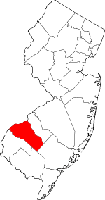 Map of New Jersey highlighting Gloucester County | |
| Boroughs | ||
| Townships | ||
| CDPs | ||
| Other unincorporated communities |
| |
| Authority control |
|
|---|