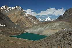
Suraj Tal
Suraj Tal or Suraj Tal Lake also called Surya taal, is a sacred body of water, literally means the Lake of the Sun God, and lies just below the Bara-lacha-la pass (4,890m) (8 km (5.0 mi) in length) in the Lahaul and Spiti valley of Himachal Pradesh state in India and is the third highest lake in India, and the 21st-highest in the world.[1][2] Suraj Tal Lake is the source of Bhaga River which joins the Chandra River downstream at Tandi to form the Chandrabhaga River in Himachal Pradesh territory, and as it enters Jammu and Kashmir it is renamed as the Chenab River.[2] The Bhaga River (a tributary of the Chandrabhaga or Chenab) originates from Surya taal. The other major tributary of the Chandrabhaga, the Chandra originates from the glacier close to the Chandra Taal lake in the Spiti district.
| Suraj Taal Surya taal | |
|---|---|
 | |
| Location | CB Range, Lahaul Valley, Himachal |
| Coordinates | 32°45′N 77°24′E |
| Type | High altitude Lake |
| Primary inflows | Glacier and Snow melt |
| Primary outflows | Bhaga River |
| Basin countries | India |
| Shore length1 | 4 km (2.5 mi) |
| Surface elevation | 4,883 m (16,020.3 ft) |
| Frozen | During winter |
| Settlements | Patseo and Darcha (mountain hamlets) |
| 1 Shore length is not a well-defined measure. | |
Access
Suraj Tal is 65 km (40.4 mi) from Keylong, the district headquarters of the Lahaul Spiti district, a frontier district of India which is approachable by road by the National Highway NH 21, also known as the Leh-Manali Highway. The NH 21 is the vital road link for the people living in the Lahaul Spiti district. The road skirts the Suraj Tal and is just 3 km (1.9 mi) short of the Bara-lacha-la pass.[3] It is sometimes falsely claimed to be the highest mountain road in the world[4] (probably the true highest road is the Semo La in Tibet) but it remains inaccessible from Rohtang Pass to Leh during winter months of November to April since the pass becomes totally snowbound during this period.[4][5][6]
Physical description
Terrain

The lake is fed from the glaciers and torrential nullahs (streams) originating from the Bara-lacha-la pass, which is 8 km (5.0 mi) long and is also called the "Pass with crossroads on summit" since roads from Zanskar, Ladakh, Spiti and Lahaul meet at this pass.[3] In addition to the Suraj Tal and the Bhaga River that originates from it, Bara-lacha-la Pass is also the source of the Chandra and Yunan Rivers in the northwest and north, respectively.[3]
The lake is situated in the Upper Himalayan Zone or High Latitudinal Zone part of the Himalayas which has very sparse population with climatic conditions akin to polar conditions. Snowfall in this zone, though scanty, is reported to be spread all round the year. Rainfall precipitation is rare in the region. Snow precipitation from snow storms is reported to be less than 20 cm (7.9 in) of snow in nearly 50% of the storms, even though one observatory in the region has reported 80 cm (31.5 in) of snow fall. The precipitation starts melting from May. Snow on slopes is generally slackly bonded, with wind redistributing it. The average total snowfall recorded in a year is reported to be 12 m (39.4 ft) –15 m (49.2 ft) with temperatures of Highest Max. 13 °C (55.4 °F), Mean Max.0.5 °C (32.9 °F),Mean Minimum minus 11.7 °C (53.1 °F) and Lowest Minimum of minus 27 °C (80.6 °F). The ground in the zone is covered with scree and boulders.[3]
Geology
The Lake's geology is represented by the Bara-lacha-la Pass, which is reported to be an early rifting event on the northern Indian passive margin and that the Basalts which are emplaced along the trans–tensional faults indicate that.[7]
Bhaga Valley
The Bhaga Valley (Tod or Stod Valley) formed from Suraj Tal up to Tandi, the confluence point with Chandra River, is 64 km (39.8 mi) long.[5] The valley, which is a narrow gorge, is devoid of any vegetation up to Darcha and thereafter it widens up to its confluence with Chandra River at Tandi with terraces between Darcha and Tandi which are under cultivation in the lower slopes, with the middle slopes having grasslands. Plantation of trees and shrubs to meet fuel wood and fodder requirements have been done on the hill slopes.[8]
Tourism
Lahaul Spiti valley is common a destination for Indian and foreign tourists for road trips, trekking and motorcycling which cover the Lake and the Bara-lacha-la pass, en route from Manali to Leh.[9]
Trekking
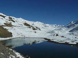
Trekking tours are a common feature. One such trek route is the Zingzingbar–Suraj Tal–Bara-lacha-la, which involves trek along the Bhaga River for 3 km (1.9 mi), cross a bridge to the North bank, then a further climb of 2.5 km (1.6 mi) from the bridge followed by a steep foot trail up to Suraj Tal.[10]
Biking tours
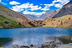
Motorcycle trips during the season when the area is approachable are undertaken by tourists. During such trips from Manali to Leh, the section between Patseo to Bara-lacha-la is a rough journey of 30 km (18.6 mi). Along this route, two small lakes, the Deepak Tal and the Suraj Tal are seen.[11]
References
- The Highest Lake in the World
- Lakes
- Training Report on Feasibility Study of Existing Manali-Darcha Highway and Proposed Darcha-Padam Road Using Remote Sensing and GIS Techniques (pages 11-13) Archived 22 September 2007 at the Wayback Machine
- Bajpai, S.C. (2002). Lahaul-Spiti: A Forbidden Land in the Himalayas. Indus Publishing. p. 130. ISBN 81-7387-113-2.
- Lahaul and Spiti District Archived 13 June 2010 at the Wayback Machine
- "Archived copy". Archived from the original on 13 July 2006. Retrieved 13 November 2008.CS1 maint: archived copy as title (link)
- "The Carboniferous Baralacha la basaltic dykes (Upper Lahul, Ladakh): remnants of an early rifting event along the Indian northern plate". Archived from the original on 8 October 2006. Retrieved 13 November 2008.
They derive from the partial melting of an enriched OIB mantle source, characterized by a HIMU component, and contaminated by the lower continental crust.
- Indian Himalayas, Lahaul and Spiti
- Suraj Tal
- Darcha Baralacha Pass Trek Lahaul
- Biking tours in Trans Himalayan Shadow
External links
| Wikimedia Commons has media related to Suraj Tal. |