Chandra Taal
Chandra Taal (meaning the Lake of the Moon), or Chandra Tal is a lake in the Spiti part of the Lahul and Spiti district of Himachal Pradesh (India).[1]
| Chandra Taal | |
|---|---|
 | |
 Chandra Taal | |
| Location | Middle Himalaya, Spiti Valley, Himachal Pradesh, |
| Coordinates | 32.47518°N 77.61706°E |
| Type | Sweet Water Lake |
| Basin countries | India |
| Max. length | 1 km (0.62 mi)[1] |
| Max. width | 0.5 km (0.31 mi)[1] |
| Surface elevation | 4,250 m (13,940 ft) |
| Islands | 1 |
| Official name | Chandertal Wetland |
| Designated | 8 November 2005 |
| Reference no. | 1569[2] |
Description
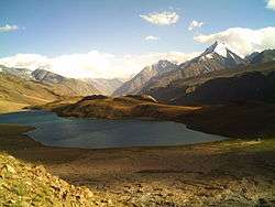
Chandra Taal lake is on the Samudra Tapu plateau, which overlooks Chandra river (a source river of the Chenab). The name of the lake originates from its crescent shape. It is at an altitude of about 4,300 metres (14,100 ft) in the Himalayas.[1] Mountains of scree overlook the lake on one side, and a cirque encloses it on the other.
Access
Chandra Taal is a tourist destination for trekkers and campers. The lake is accessible on foot from Batal as well as from Kunzum Pass from late May to early October. There is also a motor road accessible as far as a parking lot 2 kilometres (1.2 mi) from the lake. One has to travel on foot for the final 1 kilometer approximately. The route from Kunzum Pass was accessible only on foot before, but now motorcycles and 4x4 cars (Recently 4x2 also reached) do travel this distance where you take a right cut from a T-point, the road to left leads to Bataal. It takes approximately two hours from Kunzum Pass to Chandra Taal. Chandra Taal is also accessible from Suraj Tal, 30 km (19 mi) away.
Other details
Accommodation is available 5 kilometres (3.1 mi) from the lake. There are vast meadows on the banks of the lake. During springtime, these meadows are carpeted with hundreds of varieties of wild flowers.[3]
The lake is one of two high-altitude wetlands of India which have been designated as Ramsar sites. Tourism seems to be having is effect on this pristine hidden paradise.
Gallery
 Chandra Taal
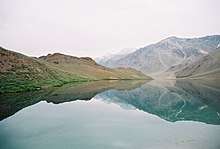
 Chandra Taal sunset
References
- "Official Website of Lahaul & Spiti District, Himachal Pradesh, India". Deputy Commissioner, Lahaul and Spiti. Retrieved 28 March 2017.
- "Chandertal Wetland". Ramsar Sites Information Service. Retrieved 25 April 2018.
- "Photographs of Chandratal Lake, Lahaul & Spiti Himalayas". Darter Photography. 20 June 2014. Retrieved 27 August 2019.