Spiti Valley
Spiti Valley is a cold desert mountain valley located high in the Himalayas in the north-eastern part of the northern Indian state of Himachal Pradesh. The name "Spiti" means "The middle land", i.e. the land between Tibet and India.[1]

Local population follow Vajrayana Buddhism similar to that found in the nearby Tibet and Ladakh regions. The valley and surrounding region is one of the least populated regions in India and is the gateway to the northernmost reaches of the nation. Along the northern route from Manali, Himachal Pradesh or Keylong via the Rohtang Pass or Kunzum Pass respectively, the valley lies in the North Eastern section of the Indian state Himachal Pradesh, and forms part of the Lahaul and Spiti district. The sub-divisional headquarters (capital) is Kaza, Himachal Pradesh[2] which is situated along the Spiti River at an elevation of about 12,500 feet (3,800 m) above mean sea level.
Lahaul and Spiti district is surrounded by high mountain ranges. The Rohtang Pass, at 13,054 feet (3,979 m), separates Lahul and Spiti from the Kullu Valley. Lahul and Spiti are cut off from each other by the higher Kunzum Pass, at 15,059 feet (4,590 m).[2] A road connects the two divisions, but is cut off frequently in winter and spring due to heavy snow. The valley is likewise cut off from the north up to eight months of the year by heavy snowfalls and thick icing conditions. A southern route to India proper is periodically closed for brief periods in the winter storms of November through June, but road access is usually restored a few days after storms end via Shimla and the Sutlej in the Kinnaur district.
Culture


Spiti valley is a research and cultural centre for Buddhists. Highlights include Key Monastery and Tabo Monastery, one of the oldest monasteries in the world and a favourite of the Dalai Lama.[3] It was the location of the scenery and cinematography in the Indian films Paap, Highway and Milarepa, a biographical adventure tale about one of Buddhism's most famous Tibetan saints. The Buddhist monastery in the valley served as the locus of the set and some of the monks appeared in the film.
The Pin Valley of Spiti is home to the few surviving Buchen Lamas of the Nyingmapa sect of Buddhism.
The small town of Manali was the beginning of an ancient trade route to Ladakh and, from there, over the Karakoram Pass on to Yarkand and Khotan in the Tarim Basin. Spiti is summer home to hundreds of semi-nomadic Gaddi sheep and goat herders who come to this valley for grazing their animals from the surrounding villages and sometimes as far as 250 km. They enter the valley during summer as the snow melts and leave just a few days before first snowfall of the season.
Transport
Spiti valley is accessible throughout the year via Kinnaur from Shimla on a difficult 412-kilometre-long (256 mi) road. Tourists from outside India need inner line permits to enter Spiti through Kinnaur. Spiti's border starts at Samdo (74 km from Kaza) which is quite near to the India–China border. In summer it can be reached via Manali through the Rohtang Pass and Kunzum Pass. Manali is 201 km from Kaza, headquarters of the Spiti subdivision. The road joining Manali to Spiti is treacherous and in bad condition as compared to the Shimla to Spiti road. A strategic 8.8 km tunnel under the Rohtang Pass will give all-weather access to Lahaul and reduce the travel distance by 48 kilometers.[4]
Due to the high altitude one is likely to feel altitude sickness in Spiti. The Shimla to Spiti route is advised for travelers coming from lower altitudes as it gives them enough time to get acclimatized to the high altitude. This is because the road runs parallel to the Sutlej river initially, climbing steadily to 2,550 metres (8,370 ft) at the confluence of the Spiti and Satluj near Khab. From Khab, the road runs along the Spiti River, climbing steeply up to Nako (elev. 3,620 metres (11,880 ft)) before continuing to Kaza.
Geography
The Spiti River originates from the Kunzum range. Tegpo and Kabzian streams are its tributaries. Water draining the famous Pin valley area is also a part of the Spiti river system. Its position across the main Himalayan range deprives it from the benefit of the South-West monsoons that causes widespread rain in most parts of India from June to September. The river attains peak discharge in late summers due to glacier melting. After flowing through Spiti valley, the Spiti River meets the Satluj near Khab and Namgia in Kinnaur district traversing a length of about 150 km. from the North-West.[5] Steep mountains rise to very high altitudes on either side of the Spiti River and its numerous tributaries. The mountains are barren and largely devoid of vegetative cover. The main settlements along the Spiti River and its tributaries are Hansi and Dhankar Gompa.
Places to visit in Spiti Valley
Places to visit include these:[6]
- Kaza
- Chandra Taal Lake
- Key Monastery
- Hikkim Village
- Kibber
- Komic Village
- Langza Village
- Lhalung Monastery
- Tabo Caves
- Tabo Monastery
- Kunzum Pass
- Chicham Bridge
- Gue
Gallery
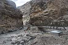
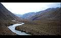 Spiti River
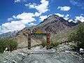 Welcome gate at Lossar, 60 km from Kaza
References
- Kapadia (1999), p. 209.
- "Himachal Tourism - Lahaul & Spiti District". Department of Tourism & Civil Aviation, Government of Himachal Pradesh. Archived from the original on 10 June 2008. Retrieved 28 September 2008.
- "Lahaul & Spiti District, Himachal Pradesh, India". District Lahaul & Spiti, Government of India. Archived from the original on 23 July 2008.
- "Coming soon: Winter access to Lahaul-Spiti". The Times of India. Retrieved 11 October 2017.
- "Khab, Himachal, OpenStreetMap.org". OpenStreetMap.org. Retrieved 14 June 2020.
- "Places to Visit in Spiti Valley | Welcome to the Heaven!". Being Himalayan. 3 February 2019. Retrieved 22 March 2019.
Bibliography
- Ciliberto, Jonathan. (2013). "Six Weeks in the Spiti Valley". Circle B Press. 2013. Atlanta. ISBN 978-0-9659336-6-7
- Francke, A. H. (1914, 1926). Antiquities of Indian Tibet. Two Volumes. Calcutta. 1972 reprint: S. Chand, New Delhi.
- Kapadia, Harish. (1999). Spiti: Adventures in the Trans-Himalaya. 2nd Edition. Indus Publishing Company, New Delhi. ISBN 81-7387-093-4.
- Banach, Benti. (2010). 'A Village Called Self-Awareness, life and times in Spiti Valley'. Vajra Publications, Kathmandu.
- Spiti Valley - An enchanting land for the wanderer in you!
External links
| Wikisource has the text of the 1911 Encyclopædia Britannica article Spiti. |