St. Bernard Parish, Louisiana
St. Bernard Parish (French: Paroisse de Saint-Bernard; Spanish: Parroquia de San Bernardo) is a parish located in the U.S. state of Louisiana. As of the 2010 census, the population was 35,897.[2] The parish seat and largest community is Chalmette.[3] The parish was formed in 1807.[4]
St. Bernard Parish | |
|---|---|
Parish | |
| Parish of St. Bernard | |
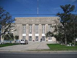 St. Bernard Parish Courthouse | |
 Flag  Seal | |
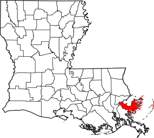 Location within the U.S. state of Louisiana | |
 Louisiana's location within the U.S. | |
| Coordinates: 29°53′N 89°21′W | |
| Country | |
| State | |
| Founded | March 31, 1807 |
| Named for | Bernardo de Galvez |
| Seat | Chalmette |
| Largest community | Chalmette |
| Area | |
| • Total | 2,158 sq mi (5,590 km2) |
| • Land | 378 sq mi (980 km2) |
| • Water | 1,781 sq mi (4,610 km2) 83% |
| Population (2010) | |
| • Total | 35,897 |
| • Estimate (2018)[1] | 46,721 |
| • Density | 17/sq mi (6.4/km2) |
| Time zone | UTC−6 (Central) |
| • Summer (DST) | UTC−5 (CDT) |
| Congressional district | 1st |
| Website | www |
St. Bernard Parish is part of the New Orleans–Metairie, LA Metropolitan Statistical Area. The parish is located southeast of New Orleans and comprises the Chandeleur Islands and Chandeleur Sound in the east. It has been ranked the fastest-growing county (parish) in the United States from 2007 to 2008 by the U.S. Census Bureau, but it is only half as populated as it was in 2005. In 2018, its population was estimated to be 46,721.
History
St. Bernard Parish contains a large community of Spanish descent. Sometimes referred to informally as "Spanish Cajuns", the Isleños are descended from Canary Islanders. This linguistically isolated group eventually developed its own dialect. The Isleños settled along Bayou Terre aux Boeufs, a relict distributary bayou of the Mississippi River. According to Dumont de Montigny, who was in Louisiana from 1719 to 1738, Terre aux Bœufs (bœuf is 'steer' or 'ox' in French, thus Terre aux Bœufs means 'land of oxen') was named in that period, presumably due to the presence of domestic or feral cattle there, and not because of bison (bison in French). This settlement was called La Concepción and Nueva Gálvez by Spanish officials, but was also called Tierra de Bueyes (Spanish for 'land of oxen'). Saint Bernard, the patron saint of colonial governor Bernardo de Gálvez, was used in documents to identify the area.[5]
St. Bernard Parish is also home to the earliest Filipino community in the United States, Saint Malo, Louisiana.
The chief historical attraction in St. Bernard Parish is the Chalmette Battlefield (part of Jean Lafitte National Historical Park and Preserve), at which the Battle of New Orleans took place on January 8, 1815, during the War of 1812. Many street names near the battlefield bear the names of the chief participants, or take a pirate theme, since the pirate Jean Lafitte was considered to be a hero in the battle. A high school, later elementary and now a middle school, was named in honor of Andrew Jackson, who was the commanding officer in charge of defending New Orleans against the British invasion.
In 1863, Abraham Lincoln mentioned St. Bernard Parish in the Emancipation Proclamation as an area not in rebellion against the Union during the Civil War.[6]
From 1919 to 1969, the parish was effectively ruled as part of the fiefdom of Leander Perez, a local Democratic official in neighboring Plaquemines Parish.
The 1868 St. Bernard Parish Massacre
In 1868, St. Bernard Parish was home to one of the deadliest massacres in Louisiana history. The St. Bernard Parish massacre occurred during the Reconstruction era, days before the Presidential election of 1868. As black men gained the right to vote, white Democrats of the parish feared losing their majority. Armed groups mobilized to violently silence these recently emancipated voters to win the election in favor of Democrat Horatio Seymour over Republican Ulysses S. Grant. A Seymour victory meant the end of Reconstruction over the South and the return of Louisiana to home rule. Many freedmen were dragged from their homes and murdered. Others fled to the cane fields to hide from the perpetrators.
The use of violence to suppress Republican votes was successful. Grant only received one vote from St. Bernard Parish, despite having a Republican majority. The reported number of freedmen killed varies from 35 to 135; the number of whites killed was two (one was killed in an attempt to help the victims).[7]
The Great Mississippi River Flood of 1927
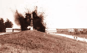
During the Great Mississippi Flood of 1927, New Orleans city and state leaders used dynamite to breach a levee at Caernarvon, 13 miles (19 km) below Canal Street, to save the city of New Orleans from flooding. At the time, it was thought by New Orleans residents that the dynamiting saved the city, but historians now believe that the dynamiting was unnecessary due to major upstream levee breaks that relieved pressure on the New Orleans levees. The levee breach caused flooding and widespread destruction in most of Eastern St. Bernard Parish and parts of Plaquemines Parish. Residents were never adequately compensated for their losses.[8]
Hurricane Katrina
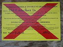
On August 29, 2005, St. Bernard was devastated by Hurricane Katrina. The storm damaged virtually every structure in the parish. The eye of Katrina passed over the eastern portion of the parish, pushing a 25-foot (7.6 m) storm surge into the Mississippi River Gulf Outlet ("MRGO"). This surge destroyed the parish levees. Almost the entire parish was flooded, with most areas left with between 5 and 15 feet (1.5–4.6 m) of standing water. The water rose suddenly and violently, during a period which witnesses reported as no more than fifteen minutes. In many areas, houses were smashed or washed off their foundations by a storm surge higher than the roofs.
For more than two months after the storm, much of the parish remained without proper services, including electricity, water, and sewage. Parish President Henry "Junior" Rodriguez declared all of the parish's homes unlivable. Emergency Communities offered one reason for hope in the first year after Hurricane Katrina. In the parking lot of a destroyed off-track betting parlor, EC built the Made with Love Cafe and Grill, a free kitchen and community center serving 1500 meals per day. Made with Love, housed in a geodesic dome, also offered food and clothing distribution, and emotionally supportive volunteers. Upon leaving, EC has offered logistical support for the founding of a new long-term Community Center of St Bernard
As of late November 2005, it was estimated that the Parish had some 7,000 full-time residents, with some 20,000 commuting to spend the day working, cleaning up, or salvaging in the parish and spending their nights elsewhere. By mid-December some businesses had returned to the Parish, most notably the ExxonMobil plant in Chalmette and the Domino Sugar plant in Arabi, together with a handful of small local stores and businesses.
At the start of January 2006, it was estimated that some 8,000 people were living in the Parish. The H.O.P.E. Project, a collective of volunteer relief workers, founded itself in January 2006 in the empty shell of the Corinne Missionary Baptist Church in Violet, LA, providing the tools for rebuilding and community empowerment. Since June 2006, Camp Hope, located in Arabi, has been housing volunteers' assisting residents of St. Bernard Parish in their recovery from Hurricane Katrina. A grassroots organization, the St. Bernard Project , opened its doors in March 2006. A fully volunteer-run organization funded by the United Way, they help residents get back into their homes by working on the houses, providing tools, support and where possible, funding.
As of October 2006, the population was estimated to be 25,489[9] After population losses due to Hurricane Katrina, the school was reopened for elementary grades for the 2006–2007 school year.
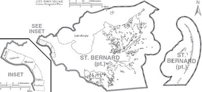
Geography
According to the U.S. Census Bureau, the parish has a total area of 2,158 square miles (5,590 km2), of which 378 square miles (980 km2) is land and 1,781 square miles (4,610 km2) (83%) is water.[10] It is the second largest parish in Louisiana by total area and has the largest percentage of area in water of any parish.
The parish of St. Bernard embraces numerous small islands. The parish is classed among the alluvial lands of the state. The ridges comprise the arable lands of the parish and have an area of 37,000 acres (150 km²). The principal streams are the Bayous Terre aux Boeufs and La Loutre. There are numerous smaller streams which are efficient drainage canals. The dominant tree species is bald cypress, of which the most valuable trees have been cut and processed.
Bodies of water
- Lake Borgne (north)
- Mississippi River (southwest)
- Gulf of Mexico (east)
Major highways
Adjacent counties and parishes
- Hancock County, Mississippi (north)
- Harrison County, Mississippi (northeast)
- Plaquemines Parish (south)
- Orleans Parish (northwest)
National protected areas
- Breton National Wildlife Refuge (part)
- Jean Lafitte National Historical Park (part, in Chalmette)
State park
Demographics
| Historical population | |||
|---|---|---|---|
| Census | Pop. | %± | |
| 1810 | 1,020 | — | |
| 1820 | 2,635 | 158.3% | |
| 1830 | 3,356 | 27.4% | |
| 1840 | 3,237 | −3.5% | |
| 1850 | 3,802 | 17.5% | |
| 1860 | 4,076 | 7.2% | |
| 1870 | 3,553 | −12.8% | |
| 1880 | 4,405 | 24.0% | |
| 1890 | 4,326 | −1.8% | |
| 1900 | 5,031 | 16.3% | |
| 1910 | 5,277 | 4.9% | |
| 1920 | 4,968 | −5.9% | |
| 1930 | 6,512 | 31.1% | |
| 1940 | 7,280 | 11.8% | |
| 1950 | 11,087 | 52.3% | |
| 1960 | 32,186 | 190.3% | |
| 1970 | 51,185 | 59.0% | |
| 1980 | 64,097 | 25.2% | |
| 1990 | 66,631 | 4.0% | |
| 2000 | 67,229 | 0.9% | |
| 2010 | 35,897 | −46.6% | |
| Est. 2019 | 47,244 | [11] | 31.6% |
| U.S. Decennial Census[12] 1790-1960[13] 1900-1990[14] 1990-2000[15] 2010-2013[2] | |||
As of the census of 2000, there were 67,229 people (an increase of 598 or 0.9% over the previous decade), 25,123 households, and 18,289 families residing in the parish. The population density was 145 people per square mile (56/km²). There were 26,790 housing units at an average density of 58 per square mile (22/km²). The racial makeup of the parish was 88.29% White, 7.62% Black or African American, 0.49% Native American, 1.32% Asian, 0.02% Pacific Islander, 0.73% from other races, and 1.52% from two or more races. 5.09% of the population were Hispanic or Latino of any race.
There were 25,123 households out of which 33.70% had children under the age of 18 living with them, 53.40% were married couples living together, 14.60% had a female householder with no husband present, and 27.20% were non-families. 22.90% of all households were made up of individuals and 10.10% had someone living alone who was 65 years of age or older. The average household size was 2.64 and the average family size was 3.12.
In the parish the population was spread out with 25.20% under the age of 18, 9.20% from 18 to 24, 29.20% from 25 to 44, 22.60% from 45 to 64, and 13.80% who were 65 years of age or older. The median age was 37 years. For every 100 females there were 93.60 males. For every 100 females age 18 and over, there were 90.10 males.
The median income for a household in the parish was $35,939, and the median income for a family was $42,785. Males had a median income of $34,303 versus $24,009 for females. The per capita income for the parish was $16,718. About 10.50% of families and 13.10% of the population were below the poverty line, including 16.50% of those under age 18 and 11.40% of those age 65 or over.
As of the census of 2010, there are 35,897 people. The racial makeup of the parish was 26,579 whites, 6,350 blacks, 690 Asians, 260 Native American, and the rest of any other race.[16]
Between the 2000 U.S. Census and the 2010 U.S. Census the Hispanic population of St. Bernard Parish increased. As of 2011 9% of the parish population is Hispanic.[17]
Education
Public schools in the parish are operated by the St. Bernard Parish Public Schools agency.
Due to Hurricane Katrina, the parish's 20 plus public schools were consolidated as one school, the St. Bernard Unified School, or SBUS. St. Bernard Unified School broke up into several different schools in the 2006-2007 school year.
The parish is served by Nunez Community College.
As of 2011, the Public School System has expanded. Andrew Jackson High School was converted into a Middle School. Lacoste Elementary has been converted into a Ninth Grade Academy. Trist Middle School is once again serving as a Middle School.
At the start of the 2016-2017 school year there was one high school, Chalmette High school and Chalmette High Ninth Grade Academy (old Lacoste Elementary). There were three middle schools, Andrew Jackson Middle (old Andrew Jackson High), St Bernard Middle School (old St. Bernard High), and N. P. Trist Middle. Six elementary schools service the parish: Arabi Elementary, Chalmette Elementary (old Chalmette Middle), Joseph Davies Elementary, J. F. Gauthier Elementary (new building, the old Gauthier is close due to mold), Lacoste Elementary (old St. Mark's Catholic School) and William Smith Elementary. There is also C. F. Rowley Alternative School.
St. Bernard Parish also has only one Catholic school, Our Lady of Prompt Succor. There is also one Christian school, Classique Academy.
Media
While St. Bernard is served mainly by New Orleans media sources, such as a local section of The Times-Picayune, the Parish does have multiple newspapers. The St. Bernard Voice, established in 1890, serves as the official journal of the parish.[18] The St. Bernard News was established in 1967 and publishes weekly.
Formerly published newspapers that served the parish include the St. Bernard Eagle and the St. Bernard Weekly Eagle which published in the 1870s through 1884 in Arabi, Progress which published from Stock Landing (Arabi) in 1888-1889, St. Bernard Protector 1925-1926, and the St. Bernard Guide which published from 1982-1986.[19]
Politics
| Year | Republican | Democratic | Third parties |
|---|---|---|---|
| 2016 | 64.7% 10,237 | 31.4% 4,960 | 3.9% 618 |
| 2012 | 60.9% 8,501 | 36.3% 5,059 | 2.8% 395 |
| 2008 | 71.2% 9,643 | 25.8% 3,491 | 3.0% 407 |
| 2004 | 65.7% 19,597 | 33.4% 9,956 | 1.0% 285 |
| 2000 | 56.8% 16,255 | 40.8% 11,682 | 2.4% 684 |
| 1996 | 43.9% 13,549 | 46.3% 14,312 | 9.8% 3,031 |
| 1992 | 49.0% 16,131 | 37.4% 12,305 | 13.7% 4,502 |
| 1988 | 61.8% 19,609 | 35.9% 11,406 | 2.3% 721 |
| 1984 | 74.8% 24,428 | 24.7% 8,076 | 0.5% 153 |
| 1980 | 60.5% 19,410 | 35.5% 11,367 | 4.0% 1,288 |
| 1976 | 47.9% 12,707 | 48.9% 12,969 | 3.1% 832 |
| 1972 | 77.7% 15,198 | 16.3% 3,189 | 6.0% 1,176 |
| 1968 | 18.3% 3,486 | 13.1% 2,485 | 68.6% 13,056 |
| 1964 | 56.6% 8,055 | 43.4% 6,175 | |
| 1960 | 13.1% 1,431 | 42.6% 4,660 | 44.4% 4,858 |
| 1956 | 50.6% 3,648 | 45.5% 3,283 | 4.0% 286 |
| 1952 | 51.7% 2,267 | 48.3% 2,117 | |
| 1948 | 4.4% 107 | 3.7% 91 | 91.9% 2,247 |
| 1944 | 3.8% 80 | 96.2% 2,044 | |
| 1940 | 6.0% 110 | 94.0% 1,715 | |
| 1936 | 1.1% 25 | 98.9% 2,269 | |
| 1932 | 6.5% 106 | 93.5% 1,525 | |
| 1928 | 3.2% 77 | 96.8% 2,359 | |
| 1924 | 2.4% 13 | 97.6% 526 | |
| 1920 | 13.5% 56 | 86.5% 358 | |
| 1916 | 5.9% 23 | 92.8% 363 | 1.3% 5 |
| 1912 | 6.8% 17 | 88.4% 221 | 4.8% 12 |
Communities

There are no incorporated areas in St. Bernard Parish.
Unincorporated communities
Ghost towns
- Alluvial City[21]
- Fazendeville
- Proctorville
- St. Malo
Notable people
- Renato Beluche
- P. G. T. Beauregard
- Walter Boasso
- A. G. Crowe
- Albert Estopinal
- Ray Garofalo
- Nita Rusich Hutter
- Samuel B. Nunez Jr.
- Kenneth L. Odinet Sr.
- Leander Perez
- François Marie, Chevalier de Reggio
- Edward Ripoll
- Mitchell Robinson
- Junior Rodriguez
- Jean Saint Malo
- Elmer R. Tapper
- Jacques Villeré
- Norris Weese
- Tommy Wiseau
References
- https://www.census.gov/quickfacts/fact/table/stbernardparishlouisiana/PST045217
- "State & County QuickFacts". United States Census Bureau. Retrieved August 18, 2013.
- "Find a County". National Association of Counties. Retrieved 2011-06-07.
- "St. Bernard Parish". Center for Cultural and Eco-Tourism. Retrieved September 6, 2014.
- Din, Gilbert (1988). The Canary Islanders of Louisiana.
- "National Capital Regional Office". National Park Service. Retrieved 2018-02-16.
- Dier, Chris (2017). The 1868 St. Bernard Parish Massacre: Blood in the Cane Fields. The History Press. ISBN 1540227014.
- Barry, John M. Rising Tide: The Great Mississippi Flood of 1927 and How It Changed America (1998 paperback ed.). New York: Touchstone Books. pp. 253–258. ISBN 0-684-84002-2.
- "New Orleans population still cut by more than half". Reuters. November 29, 2006. Retrieved December 6, 2006.
- "2010 Census Gazetteer Files". United States Census Bureau. August 22, 2012. Archived from the original on September 28, 2013. Retrieved September 1, 2014.
- "Population and Housing Unit Estimates". Retrieved April 10, 2020.
- "U.S. Decennial Census". United States Census Bureau. Retrieved September 1, 2014.
- "Historical Census Browser". University of Virginia Library. Retrieved September 1, 2014.
- "Population of Counties by Decennial Census: 1900 to 1990". United States Census Bureau. Retrieved September 1, 2014.
- "Census 2000 PHC-T-4. Ranking Tables for Counties: 1990 and 2000" (PDF). United States Census Bureau. Retrieved September 1, 2014.
- http://2010.census.gov Archived 2013-10-06 at the Wayback Machine
- Hernandez, Monica. "Census shows growing Hispanic population in Jefferson Parish." (Archive) WWL-TV. February 4, 2011. Updated Saturday February 5, 2011. Retrieved on March 22, 2013.
- Louisiana Secretary of State. "Official Parish Journals" (PDF). Retrieved 2012-05-30.
- Louisiana State University Libraries Special Collections. "Louisiana Newspaper Project". Archived from the original on 2010-02-04. Retrieved 2012-05-30.
- Leip, David. "Dave Leip's Atlas of U.S. Presidential Elections". uselectionatlas.org. Retrieved 2018-02-16.
- U.S. Geological Survey. Geographic Names Phase I data compilation (1976-1981). 31-Dec-1981. Primarily from U.S. Geological Survey 1:24,000-scale topographic maps (or 1:25K, Puerto Rico 1:20K) and from U.S. Board on Geographic Names files. In some instances, from 1:62,500 scale or 1:250,000 scale maps.
External links
| Wikimedia Commons has media related to Saint Bernard Parish, Louisiana. |
- Official website of the St. Bernard's Parish Government
- Official website of the St. Bernard Parish Tourist Commission
- St. Bernard Chamber of Commerce
- Los Isleños Heritage and Cultural Society
- St.Bernard Project Official Website
- St. Bernard Project Wikipedia Page
- H.O.P.E. Project of Violet, Louisiana
- Post-Katrina cleanup and volunteer efforts
- "Hurricane Journal", Samantha Perez of St. Bernard Parish
- St Bernard Health Statistics, History, and Vital Information
- Chalmation.net St. Bernard Internet Portal
- St. Bernard Parish Net Online Guide to St. Bernard Parish
- Geology and Hurricane-Protection Strategies in the Greater New Orleans Area
- Engineering Geology of St. Bernard Parish, Louisiana
- Water Resources of St. Bernard Parish, Louisiana United States Geological Survey
Places adjacent to St. Bernard Parish, Louisiana | ||||||||||
|---|---|---|---|---|---|---|---|---|---|---|
| ||||||||||
Municipalities and communities of St. Bernard Parish, Louisiana, United States | ||
|---|---|---|
Parish seat: Chalmette | ||
| CDPs | | |
| Unincorporated communities |
| |
| Ghost towns |
| |
| Authority control |
|
|---|