Chalmette, Louisiana
Chalmette (/ʃælˈmɛt/ shall-MET) is a census-designated place (CDP) in, and the parish seat of St. Bernard Parish, in southeast Louisiana, United States.[1] The 2010 census reported that Chalmette had 16,751 people. The 2011 population is listed as 17,119;[2] however, the pre-Katrina population was 32,069 at the 2000 census. The population hence declined by 46% between 2000 and 2010. Chalmette is part of the New Orleans–Metairie–Kenner Metropolitan Statistical Area. Chalmette is located east of downtown New Orleans and south of Arabi, towards Lake Borgne.
Chalmette, Louisiana | |
|---|---|
Census-designated place | |
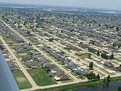 View of Chalmette residential area | |
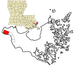 Location in St. Bernard Parish and the state of Louisiana. | |
| Coordinates: 29°56′44″N 89°57′42″W | |
| Country | United States |
| State | Louisiana |
| Parish | St. Bernard |
| Area | |
| • Total | 7.9 sq mi (20 km2) |
| • Land | 7.3 sq mi (19 km2) |
| • Water | 0.6 sq mi (2 km2) |
| Elevation | 3 ft (0.9 m) |
| Population (2011) | |
| • Total | 17,119 |
| • Density | 2,200/sq mi (840/km2) |
| Time zone | UTC-6 (CST) |
| • Summer (DST) | UTC-5 (CDT) |
| Area code(s) | 504 |

The community was named for plantation owner Louis-Xavier Martin de Lino de Chalmette (1720-1755). Chalmette was appended to the family name after acquiring their Louisiana plantation, in honour of Louis-Xavier Martin de Lino's paternal great-grandmother, Antoinette Chalmette (died 1711)[3] "Chalmette," in French, means pasture, or fallow land, (and traces to the Proto-Celtic word "kalm").
History

Chalmette was founded by plantation owner Louis-Xavier Martin de Lino de Chalmette (1720-1755), a native of Quebec and grandson of René-Louis Chartier de Lotbinière of Maison Lotbinière. His eldest son, Louis Xavier Martin de Lino de Chalmette (1753-1814) was born there and married the sister of Antoine Philippe de Marigny, grandfather of Bernard de Marigny.
In January 1815, the Battle of New Orleans was fought at the Chalmette plantation, then owned by his second son, Ignace Martin de Lino de Chalmette (1755-1815), a maternal half-brother of Col. Pierre Denis de La Ronde (founder of Versailles, Louisiana), who commanded the Louisiana militia's Third Regiment during the battle.[4] The American forces under Major General Andrew Jackson defeated the British forces (led by brevet Lieutenant General Sir Edward Pakenham). While occupied by the British, on Andrew Jackson's orders, the Chalmette plantation was completely destroyed during the Battle of New Orleans.

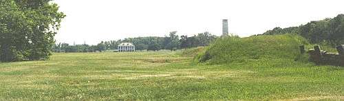
The battlefield is preserved as a national monument complete with visitor center, and the Chalmette National Cemetery is adjacent. Since the mid-1970s, the site has been part of the Jean Lafitte National Historical Park and Preserve, a multi-site National Park Service property with its headquarters located in the French Quarter of New Orleans.
The Greek Revival-style plantation house next to the Chalmette battlefield, named the Malus-Beauregard House, was built in 1830 and is open to the public.[5]
From 1951 to 1983, Chalmette was the location of a major Kaiser Aluminum plant.[6]
Hurricane Katrina
On August 29, 2005, a 25-foot (7.6 m) storm surge from Hurricane Katrina overflowed through the Mississippi River–Gulf Outlet Canal (commonly known as MRGO) — a commercial channel dug by the United States Army Corps of Engineers in the 1960s — and flooded most of the town, with waters as high as 14 to 15 feet (4.9 m)[7] in some places. As a result, Chalmette was extensively swamped and destroyed. A majority of the population evacuated shortly before the storm hit, but there was still significant loss of life.
As of 25 October 2005, most of the buildings were deemed unsalvageable. Despite findings published by the U.S. EPA, the toxic chemicals in the water from local oil refineries have been postulated to be an ongoing health hazard by several civilian ecological groups. Especially notable was the large oil spill originating in Chalmette's Murphy Oil facility, where the storm surge knocked over a huge oil tank (see photo below).[8]

The parish administrative headquarters served as the site for a Federal Emergency Management Agency (FEMA) trailer park for numerous civil servants who were laboring in the rebuilding effort. A year later, parish employees were still working shifts around the clock to bring the community back to life.
Another center in the rebuilding effort was centered at the church of Our Lady of Prompt Succor, which served the congregations of the seven other Roman Catholic parishes as well as the main office of Catholic Relief Services. It also served as the only place to hold funerals for the first 12 months after Katrina.

Deputies working for the St. Bernard Parish Sheriff stated in early December 2005 that the oil tank floated in the flood. When the water receded, the tank settled on uneven ground. Its structural integrity was compromised, and then the oil spill occurred. By late November, the Murphy facility was functional, as was a small cluster of businesses around the intersection of Paris Road and St. Bernard Highway, on the least damaged River side of Chalmette. The devastated residential areas farther away from the River were open during daylight hours, for residents to salvage belongings from their damaged homes. The majority of people staying in Chalmette full-time were living in trailers, which began to be supplied by FEMA or private enterprises on October 12; although many who had been promised FEMA trailer housing were still waiting as late as March 2006, seven months after the hurricane.

"Camp Premier," renamed "Camp Hope," was established as a base camp for the community's rebuilding efforts, facilitating the work of relief organizations, the National Guard, and private individuals. As of August 2007, the camp is located at P.G.T. Beauregard Middle School and operated by Habitat for Humanity, to provide for relief volunteers in St. Bernard Parish. Other organizations, such as the St. Bernard Project, have also participated in the rebuilding of Chalmette, from distributing supplies, to clearing debris, to repairing damaged houses.
The Chalmette Battlefield was also partially flooded in low-lying areas, destroying the visitor center, which has since been rebuilt.
Gradual recovery
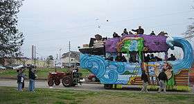
St. Bernard Parish has celebrated Mardi Gras with parades in Chalmette. In February 2006, the krewe of the Knights of Nemesis held a parade, past many buildings still in ruins, along the streets of Chalmette.
As of early 2008, many businesses have returned to the area, schools have reopened, although the population remains significantly below pre-Katrina levels.
Due to Hurricane Katrina, the St. Bernard Parish School Board succeeded in getting a school open despite considerable difficulties, including telling FEMA that it would not wait for the agency. The parish opened the St. Bernard Unified School as a K-12 school in late 2005.
With the opening of the 2006–2007 school year, the Unified school reverted to Chalmette High School and now houses grades 9-12. The former Andrew Jackson High School has been repaired and now houses grades 6–8. Trist Middle School houses grades 6 through 8.
The Catholic and private school sector was lost to Katrina. The archdiocese of New Orleans has consolidated all local schools into one, on the Our Lady of Prompt Succor campus. It has grades PK-8.
Geography
Chalmette is located at 29°56′44″N 89°57′42″W (29.945504, -89.961602),[9] along the Mississippi River and has an elevation of 3 feet (0.9 m).[10] It is located east of New Orleans, and is part of the Greater New Orleans Area.
According to the United States Census Bureau, the CDP has a total area of 7.9 square miles (20 km2), of which 7.3 square miles (19 km2) is land, and 0.6 square miles (1.6 km2) (7.56%) is water.
Chalmette lies on the east bank of the Mississippi River, just downriver from Arabi, approximately two miles (3 km) from the border of New Orleans.
Demographics
| Historical population | |||
|---|---|---|---|
| Census | Pop. | %± | |
| 1980 | 33,847 | — | |
| 1990 | 31,860 | −5.9% | |
| 2000 | 32,069 | 0.7% | |
| 2010 | 16,751 | −47.8% | |
| Est. 2011 | 17,119 | 2.2% | |
| U.S. Decennial Census | |||
As of the census of 2000, there were 32,069 people, 12,321 households, and 8,821 families residing in the CDP. The population density was 4,369.6 people per square mile (1,686.9/km²). There were 12,896 housing units at an average density of 1,757.2 per square mile (678.4/km²). The racial makeup of the CDP was 92.69% White, 2.39% African American, 0.44% Native American, 1.80% Asian, 0.03% Pacific Islander, 0.95% from other races, and 1.71% from two or more races. Hispanic or Latino of any race were 4.81% of the population.
There were 12,321 households, out of which 31.8% had children under the age of 18 living with them, 52.3% were married couples living together, 14.7% had a female householder with no husband present, and 28.4% were non-families. 23.7% of all households were made up of individuals and 10.0% had someone living alone who was 65 years of age or older. The average household size was 2.57, and the average family size was 3.04.
In the CDP, the population was spread out, with 23.7% under the age of 18, 10.0% from 18 to 24, 28.1% from 25 to 44, 23.9% from 45 to 64, and 14.3% who were 65 years of age or older. The median age was 37 years. For every 100 females, there were 94.6 males. For every 100 females age 18 and over, there were 91 males.
The median income for a household in the CDP was $36,699, and the median income for a family was $43,804. Males had a median income of $33,916 versus $24,896 for females. The per capita income for the CDP was $17,480. About 9.2% of families and 12.0% of the population were below the poverty line, including 16.5% of those under age 18 and 8.5% of those age 65 or over.
As of the 2010 census, Chalmette's demographics have changed substantially, with nearly half the population it had in 2000, at 16751. Of these, 1726 were Hispanic or Latino, constituting 10.3% of the population. The makeup of Chalmette's non-Hispanic population was 101 (0.6%) were American Indian or Alaskan native, 501 (2.99%) were Asian, 2207 (13.18%) were black, 16 (0.1%) were Pacific Islanders, 548 (3.27%) were mixed-race, 12727 (75.98%) white, and 651 (3.89%) other races. The only groups in Chalmette to grow in population were Pacific Islander, Hispanic, black, mixed, and other; on the other hand, the white population dropped by other 50%. As well, over half of the female population vanished from Chalmette while only 44.62% of the male population did, changing it from a 51.38% female town to a 51.29% male town. The changes are generally attributed to Hurricane Katrina.
Sports and recreation
Education

Chalmette is served by the St. Bernard Parish Public Schools district. As of 2007, Chalmette is served by schools in unincorporated areas:
- Andrew Jackson Elementary School (in Chalmette)
- Trist Middle School (in the community of Meraux)
- Chalmette High School (in Chalmette)
Private schools include:
- Our Lady of Prompt Succor Catholic School (K-8)
Before Katrina, Chalmette was served by other public schools including:
- C.F. Rowley Elementary School
- Joseph J. Davies Elementary School
- Lacoste Elementary School
- Lynn Oaks (K-7)
- Trist Middle School
- Chalmette Middle School
- Chalmette Senior High School
- Andrew Jackson Fundamental Magnet High School (now the site of Andrew Jackson Middle School)
- St. Bernard High School
- Carolyn Park Elementary
- Arabi Elementary
- Arabi Park Middle
- Sebastion Roy Elementary
- Millaudon Elementary
- P.G.T Beauregard
Private schools:
- One In Christ Academy (Pre-K-8)
- Archbishop Hannan High School
- Saint Robert Bellarmine Catholic School (Pre-K- 8)
- Saint Mark Elementary
- Saint Louise de Marilac Elementary
Notable people
- Alexis Marceaux, lead singer and auxiliary percussion player for Louisiana drum pop band, Sweet Crude.
- Mitchell Robinson, American basketball player for the New York Knicks of the NBA
- Norris Weese, quarterback for Ole Miss and the Denver Broncos
- Tommy Wiseau, director of the cult classic The Room, often described as one of the worst movies ever made[13]
See also
- Andrew Jackson Fundamental Magnet High School
- Chalmette High School
- Chalmette National Cemetery
- Nita Rusich Hutter
- Samuel B. Nunez, Jr.
- Leander Perez
- Jean Lafitte National Historical Park and Preserve
- The Colony U.S. TV series
References
- "Find a County". National Association of Counties. Archived from the original on 2011-05-31. Retrieved 2011-06-07.
- "People in Chalmette, Louisiana", BestPlaces.com, 2011, webpage: BPch.
- Fichier Origines: "buried 6 Feb. 1711" — most sources mistakenly state 1731, when her son died. "MARTIN / DELINO, François-Mathieu" No. 242793.
- Pierre Denis de la Ronde, fils Archived 2016-09-25 at the Wayback Machine at the Dictionary of Louisiana Biography, retrieved 10 April 2017.
- "Chalmette Battlefield & Beauregard House - Experience New Orleans!". experienceneworleans.com.
- Binczewski, George J. (February 2002). "The Energy Crisis and the Aluminum Industry: Can We Learn from History?". JOM Magazine. Retrieved 2014-05-31.
- "Six months Later—A Vision of Chaos, Determination, Courage, and Generosity" (report), Heidi (health care worker), St. Bernard Parish Medical HHS Clinic, Chalmette, LA, webpage: ADC Archived September 27, 2007, at the Wayback Machine: notes how flood trapped people in attics, in standing water.
- Meiners, Joan; The Times-Picayune; The Advocate (27 December 2019). "How Oil Companies Avoided Environmental Accountability After 10.8 Million Gallons Spilled". ProPublica. Retrieved 29 December 2019.
- "US Gazetteer files: 2010, 2000, and 1990". United States Census Bureau. 2011-02-12. Retrieved 2011-04-23.
- "US Board on Geographic Names". United States Geological Survey. 2007-10-25. Retrieved 2008-01-31.
- "Frederick J. Sigur Civic Center". frenchquarter.com. Retrieved 2018-03-13.
- "Val Riess Recreation Complex". visitstbernard.com. Retrieved 2018-03-12.
- "Capone's wacky Windy City weekend with Wiseau, creator of THE ROOM!!!". Ain't It Cool News. April 12, 2010. Retrieved 2013-01-20.
External links
| Wikimedia Commons has media related to Chalmette, Louisiana. |
- Chalmette Battlefield - Visitor Information: from National Park Service, nps.gov.
- Chalmette photos after Hurricane Katrina, photos of Katrina damage in Wikimedia Commons.
- Chalmette photos after Hurricane Katrina on KatrinaDestruction.com, from late September 2005.
Municipalities and communities of St. Bernard Parish, Louisiana, United States | ||
|---|---|---|
Parish seat: Chalmette | ||
| CDPs | 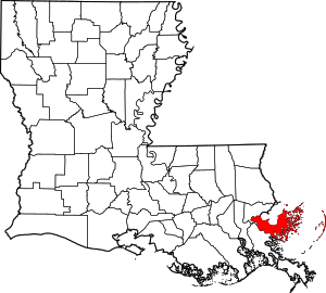 | |
| Unincorporated communities |
| |
| Ghost towns |
| |
Baton Rouge (capital) | ||
| Topics |
| |
| Society |
| |
| Regions |
| |
| Cities | ||
| CDPs | ||
| Metros | ||
| Parishes | ||

| Authority control |
|
|---|