Pointe Coupee Parish, Louisiana
Pointe Coupee Parish, (/ˈpɔɪnt kəˈpiː/ or /ˈpwɑːnt kuːˈpeɪ/; French: Paroisse de la Pointe-Coupée), is a parish located in the U.S. state of Louisiana. As of the 2010 census, the population was 22,802.[1] The parish seat is New Roads.[2]
Pointe Coupee Parish | |
|---|---|
Parish | |
| Parish of Pointe Coupee | |
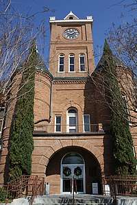 Pointe Coupee Parish Courthouse | |
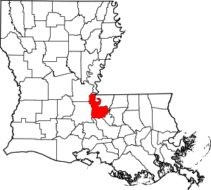 Location within the U.S. state of Louisiana | |
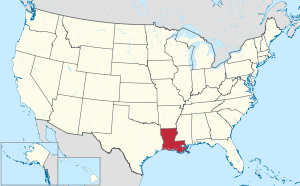 Louisiana's location within the U.S. | |
| Coordinates: 30°43′N 91°36′W | |
| Country | |
| State | |
| Founded | 1807 |
| Named for | French for the place of the cut-off |
| Seat | New Roads |
| Largest city | New Roads |
| Area | |
| • Total | 591 sq mi (1,530 km2) |
| • Land | 557 sq mi (1,440 km2) |
| • Water | 33 sq mi (90 km2) 5.6% |
| Population (2010) | |
| • Total | 22,802 |
| • Estimate (2018) | 21,940 |
| • Density | 39/sq mi (15/km2) |
| Demonym(s) | Pointe Coupean |
| Time zone | UTC−6 (Central) |
| • Summer (DST) | UTC−5 (CDT) |
| ZIP Codes | 70715, 70729, 70732, 70736, 70747, 70749, 70752, 70753, 70755, 70756, 70759, 70760, 70762, 70773, 70783 |
| Area code | 225 |
| Congressional district | 6th |
| Website | www |

Pointe Coupee Parish is part of the Baton Rouge, LA Metropolitan Statistical Area.
In 2010, the center of population of Louisiana was located in Pointe Coupee Parish, in the city of New Roads.[3]
History
Pointe Coupee Parish (originally and recently, informally pronounced pwahnt coo-pay) was organized by European Americans in 1805 as part of the Territory of Orleans (statehood for Louisiana followed in 1812). It was originally called Pointe Coupee County, and was one of the original 12 counties of the Territory of Orleans. It was renamed as Pointe Coupee Parish in 1816. The original Pointe Coupee Parish included parts of present day Iberville and West Baton Rouge Parishes. There were minor boundary adjustments with neighboring parishes up through 1852, when its boundaries stabilized.[4]
In 2008, Pointe Coupee was one of the communities that suffered the most damage by Hurricane Gustav.
Geography
According to the U.S. Census Bureau, the parish has a total area of 591 square miles (1,530 km2), of which 557 square miles (1,440 km2) is land and 33 square miles (85 km2) (5.6%) is water.[5] The land consists mainly of prairies and backswamp.
Major highways
Pointe Coupee Parish has 498.98 miles of highways within its borders.[6]


Major waterways
- Atchafalaya River
- False River
- Mississippi River
- Old River
- Raccourci Old River (not a river but an oxbow lake)
- Red River
Adjacent parishes
- Concordia Parish (north)
- West Feliciana Parish (northeast)
- West Baton Rouge Parish (east)
- Iberville Parish (south)
- St. Martin Parish (southwest)
- St. Landry Parish (west)
- Avoyelles Parish (northwest)
National protected area
Demographics
| Historical population | |||
|---|---|---|---|
| Census | Pop. | %± | |
| 1810 | 3,187 | — | |
| 1820 | 4,912 | 54.1% | |
| 1830 | 5,942 | 21.0% | |
| 1840 | 7,898 | 32.9% | |
| 1850 | 11,339 | 43.6% | |
| 1860 | 17,718 | 56.3% | |
| 1870 | 12,981 | −26.7% | |
| 1880 | 17,785 | 37.0% | |
| 1890 | 19,613 | 10.3% | |
| 1900 | 25,777 | 31.4% | |
| 1910 | 25,289 | −1.9% | |
| 1920 | 24,697 | −2.3% | |
| 1930 | 21,007 | −14.9% | |
| 1940 | 24,004 | 14.3% | |
| 1950 | 21,841 | −9.0% | |
| 1960 | 22,488 | 3.0% | |
| 1970 | 22,002 | −2.2% | |
| 1980 | 24,045 | 9.3% | |
| 1990 | 22,540 | −6.3% | |
| 2000 | 22,763 | 1.0% | |
| 2010 | 22,802 | 0.2% | |
| Est. 2018 | 21,940 | [7] | −3.8% |
| U.S. Decennial Census[8] 1790-1960[9] 1900-1990[10] 1990-2000[11] 2010-2013[1] | |||
As of the census[12] of 2000, there were 22,763 people, 8,397 households, and 6,171 families residing in the parish. The population density was 41 people per square mile (16/km²). There were 10,297 housing units at an average density of 18 per square mile (7/km²). The racial makeup of the parish was 68.91% White, 29.61% Black or African American, 0.17% Native American, 0.25% Asian, 0.32% from other races, and 0.56% from two or more races. 1.08% of the population were Hispanic or Latino of any race. 93.61% of the population spoke only English at home, while 4.89% spoke French or Cajun French, 0.96% spoke Spanish, and 0.73% spoke Louisiana Creole French.
There were 8,397 households out of which 35.20% had children under the age of 18 living with them, 53.70% were married couples living together, 15.30% had a female householder with no husband present, and 26.50% were non-families. 23.40% of all households were made up of individuals and 11.10% had someone living alone who was 65 years of age or older. The average household size was 2.67 and the average family size was 3.17.
In the parish the population was spread out with 27.30% under the age of 18, 8.80% from 18 to 24, 27.00% from 25 to 44, 23.10% from 45 to 64, and 13.90% who were 65 years of age or older. The median age was 37 years. For every 100 females, there were 94.40 males. For every 100 females age 18 and over, there were 90.70 males.
The median income for a household in the parish was $30,618, and the median income for a family was $36,625. Males had a median income of $35,022 versus $20,759 for females. The per capita income for the parish was $15,387, ranking 23rd out of 64 parishes. About 18.70% of families and 23.10% of the population were below the poverty line, including 30.20% of those under age 18 and 23.90% are the age of 65 and older.
Economy
Nan Ya Plastics Corporation America has a large plant near Batchelor. Another large employer is NRG / Big Cajun 1 & 2 power plants near New Roads. The parish's economy is heavily reliant upon agriculture, with sugar cane being one of the main cash crops.
Education
Schools
The Pointe Coupee Parish School Board serves the parish.
As of 2014 the sole secondary school operated by the parish school board is Livonia High School, serving grades 7 through 12. Pointe Coupee Central High School was closed down in 2014. Current public schools include Stem Magnet Academy, Valverda Elemtary, Rougon, Rosenwald, and Upper Pointe Coupee Elementary.
Private
- Catholic Elementary of Pointe Coupee / Catholic High School of Pointe Coupee
- False River Academy
National Guard
A Co of the 769th BEB (Brigade Engineer Battalion) is an Engineer Company (Combat) that resides in New Roads, Louisiana. This unit is part of the 256TH IBCT and deployed to Iraq in 2004-5 and 2010.
Communities

City
- New Roads (parish seat)
Village
Census-designated place
Unincorporated communities
- Aline
- Allon
- Alma
- Anchor
- Argyle
- Bayou Latenache
- Batchelor
- Beaud
- Blanks
- Brooks
- Brownview
- Chenal
- Columbo
- Coon
- Dupont
- False River
- East Krotz Springs
- Elliot City
- Frisco
- Frogmore
- Glynn
- Hermitage
- Ingleside
- Innis
- Island
- Jacoby
- Jarreau
- Keller
- Knapp
- LaBarre
- Lacour
- Lakeland
- Leavel
- Legonier
- Lettsworth
- Lottie
- Major
- McCrea
- McKneeley
- Mix
- Morrison
- New California
- New Texas
- Oscar
- Parlange
- Patin
- Point Coupee
- Quinton
- Ravenswood
- Red Cross
- Red River Landing
- Rougon
- Seibert
- Schwabs
- Sherburne
- Shexnayder
- Smithland
- Sparks
- St. Dizier
- Torbert
- Torras
- Valverda
- Waterloo
- Wickliffe
- Williamsport
Notable residents
- Lindy Boggs (1916-2013) – U.S. Representative from Louisiana's 2nd congressional district and U.S. Ambassador to the Holy See. She was a Dame of the Orders of Malta, St. Lazarus and Holy Sepulchre as well as the Pian Order.
- Brian J. Costello, native and lifelong resident of New Roads, Pointe Coupee Parish, is a noted humanitarian, author of more than two dozen books on local, Louisiana, European and religious studies and is a Knight of the Imperial Teutonic, St. Lazarus and Nobility of the Holy Roman Empire Orders.
- Emmitt Douglas (1926–1981) – president of the Louisiana NAACP from 1966–1981, resided in New Roads from 1949–1981
- Ernest Gaines – author
- Clark Gaudin - former state representative from East Baton Rouge Parish
- Buddy Guy - Singer
- Gwendolyn Midlo Hall, historian, did extensive research and writing about slavery in Louisiana, having discovered important documentation of the slave trade and individual slaves that provided new understanding of African-American history in Louisiana, including the specific ethnic origins in various African cultures of many slaves
- Russel L. Honoré - retired Lieutenant General, U.S. Army
- J. Thomas Jewell - state representative 1936-1968; Speaker of the Louisiana House 1960-1964
- J. E. Jumonville, Jr. - state senator from District 17, 1976-1992, horse breeder
- J. E. Jumonville, Sr. - state senator, 1968-1976, natural gas developer
- Catherine D. Kimball - former Chief Justice of Louisiana Supreme Court; former judge of the Louisiana 18th Judicial District Court, 1983-1993
- Major General John Archer Lejeune, career military officer and Commandant of the United States Marine Corps.
- Hall Lyons (1923-1998) - Louisiana oilman and politician, owned at least two oil wells in Pointe Coupee Parish.
- Norma McCorvey - anonymous plaintiff in 1973 U.S. Supreme Court landmark abortion case, Roe v. Wade.
- deLesseps Story Morrison (1912–1964), born in New Roads, was elected four times as mayor of New Orleans, serving from 1946 to 1962; he ran unsuccessfully three times for governor of Louisiana. He was also the United States ambassador to the Organization of American States.
- Jacob Haight Morrison, (1905-1974), New Roads native, became a journalist, politician and preservationist, helping protect the French Quarter of New Orleans.
- Charles Parlange - former Chief Justice of Louisiana Supreme Court
- Julien Poydras – territorial U.S. Representative for Louisiana; 1st State Senate President, philanthropist
- James Ryder Randall - poet, teacher at Poydras Academy, 1856–1860, wrote "Maryland, My Maryland" while living in Pointe Coupée Parish
- Nauman Scott - judge of the United States District Court for the Western District of Louisiana, based in Alexandria
- Major Thibaut - state representative for District 18 since 2008; First Parish President
- Chris Williams - offensive tackle for the St. Louis Rams
- Clyde Kimball - former State Representative and former deputy secretary of the Louisiana Department of Wildlife and Fisheries
Politics
Prior to 2008, Pointe Coupee Parish was a Democratic stronghold in presidential elections, only failing to back the party's candidates four times between 1912 & 2004 even as the Solid South became a Republican stronghold at the presidential level. Since then, it has swung to primarily support Republican Party candidates, with Donald Trump winning the county by a margin of over seventeen points in the most recent presidential election of 2016. However, the substantial African-American minority has kept the Republican swing less pronounced compared to many other rural counties throughout the South.
| Year | Republican | Democratic | Third parties |
|---|---|---|---|
| 2016 | 57.7% 6,789 | 40.5% 4,764 | 1.8% 208 |
| 2012 | 53.9% 6,548 | 44.8% 5,436 | 1.3% 163 |
| 2008 | 53.9% 6,702 | 44.4% 5,516 | 1.8% 217 |
| 2004 | 48.2% 5,429 | 50.7% 5,712 | 1.2% 130 |
| 2000 | 43.5% 4,710 | 53.7% 5,813 | 2.9% 309 |
| 1996 | 31.3% 3,545 | 60.3% 6,835 | 8.4% 952 |
| 1992 | 31.5% 3,563 | 57.5% 6,512 | 11.0% 1,247 |
| 1988 | 39.6% 4,333 | 57.7% 6,308 | 2.6% 289 |
| 1984 | 44.6% 5,477 | 54.8% 6,732 | 0.6% 78 |
| 1980 | 35.7% 3,667 | 62.3% 6,395 | 2.0% 201 |
| 1976 | 32.6% 2,567 | 65.4% 5,147 | 2.1% 162 |
| 1972 | 46.6% 3,192 | 45.7% 3,133 | 7.7% 528 |
| 1968 | 11.3% 850 | 41.9% 3,139 | 46.8% 3,508 |
| 1964 | 50.9% 2,327 | 49.1% 2,247 | |
| 1960 | 16.4% 674 | 71.8% 2,953 | 11.8% 485 |
| 1956 | 45.0% 1,332 | 52.1% 1,542 | 2.8% 84 |
| 1952 | 45.9% 1,174 | 54.1% 1,385 | |
| 1948 | 10.0% 198 | 20.3% 402 | 69.7% 1,379 |
| 1944 | 15.9% 271 | 84.1% 1,436 | |
| 1940 | 11.6% 247 | 88.4% 1,877 | |
| 1936 | 7.6% 116 | 92.4% 1,419 | |
| 1932 | 6.0% 65 | 94.1% 1,027 | |
| 1928 | 7.1% 102 | 92.9% 1,330 | |
| 1924 | 27.7% 146 | 69.9% 369 | 2.5% 13 |
| 1920 | 26.0% 143 | 74.0% 407 | |
| 1916 | 10.5% 37 | 85.3% 301 | 4.3% 15 |
| 1912 | 12.1% 55 | 66.8% 304 | 21.1% 96 |
See also
References
- "State & County QuickFacts". United States Census Bureau. Archived from the original on January 7, 2016. Retrieved August 18, 2013.
- "Find a County". National Association of Counties. Retrieved 2011-06-07.
- "Centers of Population by State: 2010". United States Census Bureau. Retrieved September 1, 2014.
- Gold Bug Software. "AniMap Plus: County Boundary Historical Atlas".
- "2010 Census Gazetteer Files". United States Census Bureau. August 22, 2012. Archived from the original on September 28, 2013. Retrieved August 20, 2014.
- "Louisiana State Police". lsp.org.
- "Population and Housing Unit Estimates". Retrieved October 28, 2019.
- "U.S. Decennial Census". United States Census Bureau. Retrieved September 1, 2014.
- "Historical Census Browser". University of Virginia Library. Retrieved September 1, 2014.
- "Population of Counties by Decennial Census: 1900 to 1990". United States Census Bureau. Retrieved September 1, 2014.
- "Census 2000 PHC-T-4. Ranking Tables for Counties: 1990 and 2000" (PDF). United States Census Bureau. Retrieved September 1, 2014.
- "U.S. Census website". United States Census Bureau. Retrieved 2008-01-31.
- Leip, David. "Dave Leip's Atlas of U.S. Presidential Elections". uselectionatlas.org. Retrieved 2018-03-09.
External links
| Wikimedia Commons has media related to Pointe Coupee Parish, Louisiana. |
- Pointe Coupee Interactive Map
- Official Pointe Coupee Parish website
- Gwendolyn Midlo Hall, "THE LOUISIANA SLAVE DATABASE AND THE LOUISIANA FREE DATABASE: 1719-1820", iBiblio website
- Official Pointe Coupee Parish Sheriff's Office website
- Explore the History and Culture of Southeastern Louisiana, a National Park Service Discover Our Shared Heritage Travel Itinerary
- Pointe Coupee at the Millennium Documentary Photography Project
Places adjacent to Pointe Coupee Parish, Louisiana | ||||||||||
|---|---|---|---|---|---|---|---|---|---|---|
| ||||||||||
Municipalities and communities of Pointe Coupee Parish, Louisiana, United States | ||
|---|---|---|
Parish seat: New Roads | ||
| City | | |
| Towns | ||
| Village | ||
| CDP | ||
| Other unincorporated communities | ||
| Ghost towns | ||
| Authority control |
|
|---|