Ouachita Parish, Louisiana
Ouachita Parish (French: Paroisse d'Ouachita) is located in the northern part of the U.S. state of Louisiana. As of the 2010 census, the population was 153,720.[1] The parish seat is Monroe.[2] The parish was formed in 1807.[3]
Ouachita Parish, Louisiana | |
|---|---|
| Parish of Ouachita | |
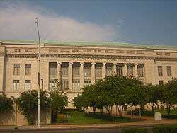 Ouachita Parish Courthouse in Monroe was built in the 1930s by the contractor George A. Caldwell | |
 Seal | |
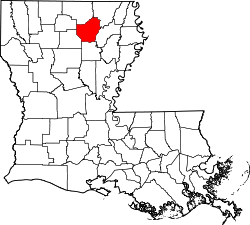 Location within the U.S. state of Louisiana | |
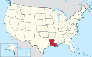 Louisiana's location within the U.S. | |
| Country | |
| State | |
| Region | North Louisiana |
| Founded | March 31, 1807 |
| Named for | Ouachita people |
| Parish seat (and largest city) | Monroe |
| Area | |
| • Total | 1,640 km2 (632 sq mi) |
| • Land | 1,600 km2 (610 sq mi) |
| • Water | 50 km2 (21 sq mi) |
| • percentage | 9 km2 (3.4 sq mi) |
| Population (2010) | |
| • Total | 153,720 |
| • Estimate (2019) | 153,279 |
| • Rank | LA: 8th |
| • Density | 94/km2 (240/sq mi) |
| Time zone | UTC-6 (CST) |
| • Summer (DST) | UTC-5 (CDT) |
| Area code | 318 |
| Congressional district | 5th |
| Website | Ouachita Parish Police Jury |

Ouachita Parish is part of the Monroe, LA Metropolitan Statistical Area. Located here is Watson Brake, the oldest indigenous earthwork mound complex in North America. It was dated to 5400 BP, or about 3500 BCE, making it older than the monuments of the Egyptian pyramids or England's Stonehenge. It is on privately owned land and not available for public viewing.[4]
History
Prehistory
Ouachita Parish was the home to many succeeding Native American groups in the thousands of years before Europeans began to settle here. Peoples of the Marksville culture, Troyville culture, Coles Creek culture and Plaquemine culture built villages and earthwork mound sites throughout the area. Notable examples include the Filhiol Mound Site, located on a natural levee of the Ouachita River.[5]
The oldest and most significant is Watson Brake, the most ancient mound complex in North America, dated to 5400 BP (before present), or about 3500 BCE. Its dating changed archeologists' understanding of the antiquity of mounds in North America and what types of cultures constructed them. This site is located on private land and not available for viewing.
Historic era
The parish was named after the Ouachita River, which flows through southern Arkansas and northeastern Louisiana, and the Ouachita tribe who lived along it. Beginning about 1720, French settlers arrived in what became organized as modern Ouachita Parish. Colonists developed a plantation on Bayou DeSiard that used African slave labor. The Natchez Indians destroyed the Ouachita plantations during the Natchez Revolt of 1729-1731, and the French did not return.
Beginning in the 1750s, Choctaw Indians began hunting in northern Louisiana, including the Ouachita country, expanding from their traditional territory in what is now Mississippi. At the time, only a few French families moved north into this area from the Opelousas Post on the Red River.
Following its defeat in the Seven Years' War, in 1763 France ceded its territories in North America east of the Mississippi River to the victor Great Britain. Spain took over French territories west of the Mississippi, including nominally in Louisiana. In 1769, Alejandro O'Reilly, the first Spanish governor to rule successfully in West Louisiana, claimed Ouachita Parish for Spain. A census of the parish that year recorded 110 white people. In 1769 Spain abolished the Indian slave trade and Indian slavery in its colonies.
Even in the 19th century, after the United States acquired this territory in the Louisiana Purchase of 1803, some mixed-race American slaves were able to win freedom suits by proving Indian ancestry in their maternal line; under most southern state slave laws, children were born into the status of the mother. Thus a mixed-race child of an Indian mother or grandmother was legally free in former Spanish territory west of the Mississippi River, such as Louisiana, Arkansas or Missouri, as the Indians had been free people since 1769.
In 1783, Don Juan Filhiol was among Frenchmen who began to work for the Spanish colonial government in Louisiana. (He was born Jean-Baptiste Filhiol (1740) in Eymet, France (near Bordeaux), to French Calvinists François Filhiol and Anne Marie Teyssonnière, cloth merchants.)[6] He was assigned that year to establish the first European outpost in the area of the Ouachita River Valley, called Poste d'Ouachita. With his wife, a few soldiers and slaves, his small party made the slow, arduous journey by keelboat up the Mississippi, Red, Black and Ouachita rivers to reach this area. In 1785 the European population of the entire Ouachita District (which extended into present-day Arkansas) was only 207.[7]
Originally based in Arkansas, Filhiol surveyed his grant and settled in 1785 at Prairie des Canots (included within the present-day city of Monroe). He gradually organized settlers, including trying to train some in military skills. He built Fort Miro on his land to provide protection for settlers from the Indians. At the same time, he worked to establish trade with the Chickasaw people and other Native Americans of the area. He was tasked with organizing the settlers in the Ouachita River Valley, while keeping out Americans and establishing good relations for trade with the Native Americans. Filhio served as commandant of Poste d'Ouachita until 1800, when he retired. He continued to live on his plantation here.[7]
Acquired by United States
Other settlers and merchants were attracted to the trading post, which became known as Fort Miro, with a town developing by 1805, two years after the United States acquired the Louisiana Purchase from France. This was the vast former French territory (France had reacquired it from Spain for a brief period) west of the Mississippi and outside the Southwest and California, which were still Spanish territory. In 1819 the Americans renamed Fort Miro as the Ouachita Post. A year or so later, they changed the town's name to Monroe, after the first steamboat to reach it in travel up the Ouachita River. The arrival of the powered paddle wheeler was a landmark event, as it connected the town to much easier travel to and from other markets and stimulated its growth.
On March 31, 1807, the Territory of Orleans was divided into 19 sub-districts. The very large Ouachita Parish was one of these original 19; later it was broken up into eight other parishes (Morehouse, Caldwell, Union, Franklin, Tensas, Madison, East Carroll, and West Carroll), as more settlers entered the area and developed towns and plantations. Some brought slaves with them, but many bought slaves at markets. In the early 19th century, a total of one million slaves were forcibly moved through the domestic slave trade from the Upper South to the Deep South of the cotton plantation districts. They traveled overland or were shipped in the coastwise trade to Gulf ports.
Post-Reconstruction to present
Following the Reconstruction era, as white Democrats regained control of the state government, they increasingly worked to re-establish dominance over the freedmen in Ouachita Parish. Elections were often won by intimidation and fraud, and they worked to establish white supremacy. Particularly in the late 19th and early 20th centuries, lynchings mostly of black men by white mobs in Ouachita and across the South were a form of racial terror by which the whites enforced their dominance. A 2015 study of lynchings found that from 1877 to 1950, a total of 38 people were lynched in Ouachita Parish.[8] This was the third-highest total in the state,[8] and the fifth-highest total of lynchings of any county in the South.[9] Among the victims was George Bolden, an illiterate black man "accused of writing a lewd note to a white woman." Before he went to trial, he was lynched near Monroe on April 30, 1919.[9]
In 1883, the first railroad bridge across the Ouachita River was built, improving connections for the town with other markets.
In 1916, the Monroe natural gas field was discovered. The field stretched more than 500 square miles (1,000 km2) and was estimated to have 6,500,000,000,000 cubic feet (180 km3) of natural gas in it. As a result, for a time the city of Monroe was known as the natural gas capital of the world. The new industry generated many jobs. From 1920 to 1930, the population of Ouachita Parish increased by more than 79 percent, to 54,000 people, as migrants arrived for work. (see Demographics section and table.)
The town of Sterlington was incorporated in August 1961, and in 1974 the town of Richwood was incorporated. Ouachita Parish's boundaries have changed 23 times during its history, mostly due to the formation of other parishes in the 19th century.
Geography
According to the U.S. Census Bureau, the parish has a total area of 632 square miles (1,640 km2), of which 610 square miles (1,600 km2) is land and 21 square miles (54 km2) (3.4%) is water.[10]
Major highways


Adjacent parishes
- Union Parish (north)
- Morehouse Parish (northeast)
- Richland Parish (east)
- Caldwell Parish (south)
- Jackson Parish (southwest)
- Lincoln Parish (west)
National protected areas
Demographics
| Historical population | |||
|---|---|---|---|
| Census | Pop. | %± | |
| 1820 | 2,896 | — | |
| 1830 | 5,140 | 77.5% | |
| 1840 | 4,640 | −9.7% | |
| 1850 | 5,008 | 7.9% | |
| 1860 | 4,727 | −5.6% | |
| 1870 | 11,582 | 145.0% | |
| 1880 | 14,685 | 26.8% | |
| 1890 | 17,985 | 22.5% | |
| 1900 | 20,947 | 16.5% | |
| 1910 | 25,830 | 23.3% | |
| 1920 | 30,319 | 17.4% | |
| 1930 | 54,337 | 79.2% | |
| 1940 | 59,168 | 8.9% | |
| 1950 | 74,713 | 26.3% | |
| 1960 | 101,663 | 36.1% | |
| 1970 | 115,387 | 13.5% | |
| 1980 | 139,241 | 20.7% | |
| 1990 | 142,191 | 2.1% | |
| 2000 | 147,250 | 3.6% | |
| 2010 | 153,720 | 4.4% | |
| Est. 2019 | 153,279 | [11] | −0.3% |
| U.S. Decennial Census[12] 1790-1960[13] 1900-1990[14] 1990-2000[15] 2010-2019[1] | |||
As of the census[16] of 2000, there were 147,250 people, 55,216 households, and 38,319 families residing in the parish. The population density was 241 people per square mile (93/km²). There were 60,154 housing units at an average density of 98 per square mile (38/km²). The racial makeup of the parish was 64.48% White, 33.63% Black or African American, 0.23% Native American, 0.64% Asian, 0.03% Pacific Islander, 0.33% from other races, and 0.67% from two or more races. 1.19% of the population were Hispanic or Latino of any race.
There were 55,216 households out of which 34.20% had children under the age of 18 living with them, 47.70% were married couples living together, 17.90% had a female householder with no husband present, and 30.60% were non-families. 25.80% of all households were made up of individuals and 9.30% had someone living alone who was 65 years of age or older. The average household size was 2.58 and the average family size was 3.12.
In the parish the population was spread out with 27.90% under the age of 18, 12.00% from 18 to 24, 27.90% from 25 to 44, 20.30% from 45 to 64, and 11.80% who were 65 years of age or older. The median age was 32 years. For every 100 females there were 89.30 males. For every 100 females age 18 and over, there were 84.50 males.
The median income for a household in the parish was $32,047, and the median income for a family was $40,206. Males had a median income of $31,616 versus $23,139 for females. The per capita income for the parish was $17,084. About 15.80% of families and 20.70% of the population were below the poverty line, including 29.70% of those under age 18 and 15.80% of those age 65 or over.
Economy
The top employers in the parish, according to the North Louisiana Economic Partnership, are:
| No. | Employer | Employees |
|---|---|---|
| 1 | CenturyLink | 2,360 |
| 2 | St. Francis Specialty Hospital | 1,584 |
| 3 | State of Louisiana | 1,363 |
| 4 | J.P. Morgan Chase | 1,291 |
| 5 | Glenwood Regional Medical Center | 1,156 |
| 6 | Wal-Mart Stores | 912 |
| 7 | Ouachita Parish | 871 |
| 8 | City of Monroe | 840 |
| 9 | Graphic Packaging International | 840 |
| 10 | Tolliver Oil & Gas | 750 |
Politics
| Year | Republican | Democratic | Third parties |
|---|---|---|---|
| 2016 | 61.4% 41,734 | 35.9% 24,428 | 2.7% 1,855 |
| 2012 | 59.8% 40,948 | 38.9% 26,645 | 1.3% 881 |
| 2008 | 62.1% 41,741 | 36.9% 24,813 | 1.0% 690 |
| 2004 | 64.8% 41,750 | 34.2% 22,016 | 1.1% 678 |
| 2000 | 60.3% 35,107 | 36.9% 21,457 | 2.8% 1,647 |
| 1996 | 49.6% 28,559 | 42.6% 24,525 | 7.8% 4,510 |
| 1992 | 48.9% 27,600 | 36.9% 20,835 | 14.3% 8,067 |
| 1988 | 67.3% 33,858 | 30.7% 15,429 | 2.0% 1,005 |
| 1984 | 69.6% 37,270 | 29.0% 15,525 | 1.5% 779 |
| 1980 | 63.0% 29,799 | 34.5% 16,306 | 2.6% 1,209 |
| 1976 | 59.5% 24,082 | 38.9% 15,738 | 1.6% 631 |
| 1972 | 74.7% 24,860 | 20.8% 6,920 | 4.5% 1,483 |
| 1968 | 31.8% 10,089 | 20.4% 6,470 | 47.8% 15,145 |
| 1964 | 83.4% 21,024 | 16.6% 4,174 | |
| 1960 | 54.6% 10,525 | 27.0% 5,202 | 18.5% 3,564 |
| 1956 | 46.8% 7,094 | 28.8% 4,372 | 24.4% 3,692 |
| 1952 | 47.5% 8,842 | 52.5% 9,775 | |
| 1948 | 16.0% 1,729 | 39.0% 4,213 | 45.0% 4,860 |
| 1944 | 29.3% 2,627 | 70.7% 6,329 | |
| 1940 | 15.1% 1,509 | 84.9% 8,506 | |
| 1936 | 12.7% 1,113 | 87.3% 7,635 | |
| 1932 | 6.6% 423 | 92.9% 5,968 | 0.6% 36 |
| 1928 | 33.5% 1,380 | 66.5% 2,739 | |
| 1924 | 22.8% 480 | 73.2% 1,542 | 4.1% 86 |
| 1920 | 10.0% 164 | 90.0% 1,481 | 0.1% 1 |
| 1916 | 2.8% 35 | 97.0% 1,215 | 0.2% 3 |
| 1912 | 1.6% 17 | 83.9% 902 | 14.5% 156 |
Education
Ouachita Parish School Board serves areas outside of the City of Monroe with primary and secondary schools. Monroe City School System serves areas within Monroe.
Monroe is also the home of the University of Louisiana at Monroe.
Media
A documentary entitled The Gift of the Ouachita by filmmaker George C. Brian (1919–2007), head of the Division of Theater and Drama at the University of Louisiana at Monroe is a history of Monroe as the "gift of the Ouachita River".
National Guard
1022nd Engineer Company (Vertical) of the 527th Engineer Battalion of the 225th Engineer Brigade is located in West Monroe, Louisiana. 528th Engineer Battalion (To the Very End) also part of the 225th Engineer Brigade is headquartered in Monroe.
Communities

Cities
- Monroe (parish seat and largest municipality)
- West Monroe
Towns
Unincorporated areas
Census-designated places
Other unincorporated communities
Notable people
- Charles Anding
- Joseph A. Biedenharn
- Evelyn Blackmon
- Frank A. Hoffmann
- Alton Hardy Howard
- James D. Halsell
- Dixon Hearne
- Sam Little
- Newt V. Mills
- Dave Norris
- Don Shows
- Dale Thorn
- Shady Wall
- Mike Walsworth
- Willie Robertson
- Phil Robertson
- Si Robertson
- Jase Robertson
- Edwin Francis Jemison (Died 17 Y.O.A.; killed at Malvern Hill, Va. 1862; 1844-1862 CSA Private-2nd Louisiana Cavalry Company C; Born in Milledgeville, Ga. later Lived in Monroe, La.)
References
- "State & County QuickFacts". United States Census Bureau. Archived from the original on June 6, 2011. Retrieved August 10, 2013.
- "Find a County". National Association of Counties. Retrieved 2011-06-07.
- "Ouachita Parish". Center for Cultural and Eco-Tourism. Retrieved September 6, 2014.
- Saunders, Joe W.; Mandel, Rolfe D.; Sampson, C. Garth; Allen, Charles M.; Allen, E. Thurman; Bush, Daniel A.; Feathers, James K.; Gremillion, Kristen J.; Hallmark, C. T.; Jackson, H. Edwin; Johnson, Jay K.; Jones, Reca; Saucier, Roger T.; Stringer, Gary L.; Vidrine, Malcolm F. (2005), "Watson Brake, a Middle Archaic Mound Complex in Northeast Louisiana", American Antiquity, 70 (4): 631–668, doi:10.2307/40035868, JSTOR 40035868
- "Indian Mounds of Northeast Louisiana:Filhiol Mound". Archived from the original on 2012-12-24. Retrieved 2011-10-20.
- "Don Juan Filhiol (1740–1821)", Encyclopedia of Arkansas Culture and History; accessed 29 April 2018
- Kelby Ouchley, "Don Juan Filhiol" Archived 2016-08-28 at the Wayback Machine, KnowLA (Encyclopedia of Louisiana)
- "Supplement: Lynchings by County/ Louisiana: Ouachita ", 3rd edition Archived 2017-10-23 at the Wayback Machine, from Lynching in America: Confronting the Legacy of Racial Terror, 2015, Equal Justice Institute, Montgomery, Alabama
- Kaleb Causey, "Ouachita Parish's bloody past appears in lynching study", News-Star, 24 February 2015; accessed 20 August 2016
- "2010 Census Gazetteer Files". United States Census Bureau. August 22, 2012. Archived from the original on September 28, 2013. Retrieved August 20, 2014.
- "Population and Housing Unit Estimates". Retrieved May 21, 2020.
- "U.S. Decennial Census". United States Census Bureau. Retrieved August 20, 2014.
- "Historical Census Browser". University of Virginia Library. Retrieved August 20, 2014.
- "Population of Counties by Decennial Census: 1900 to 1990". United States Census Bureau. Retrieved August 20, 2014.
- "Census 2000 PHC-T-4. Ranking Tables for Counties: 1990 and 2000" (PDF). United States Census Bureau. Retrieved August 20, 2014.
- "U.S. Census website". United States Census Bureau. Retrieved 2008-01-31.
- Leip, David. "Dave Leip's Atlas of U.S. Presidential Elections". uselectionatlas.org. Retrieved 2018-03-07.
Places adjacent to Ouachita Parish, Louisiana | ||||||||||
|---|---|---|---|---|---|---|---|---|---|---|
| ||||||||||
Municipalities and communities of Ouachita Parish, Louisiana, United States | ||
|---|---|---|
Parish seat: Monroe | ||
| Cities | | |
| Towns | ||
| CDPs | ||
| Other unincorporated communities | ||
| Authority control |
|
|---|