Srīpur (crater)
Srīpur is a Martian impact crater, approximately 23 kilometers in diameter. It is located at -31.1°S, 100.8°W, southeast of the crater Dinorwic and northeast of the crater Tugaske. It is named for a town in Bangladesh, and its name was adopted by the International Astronomical Union in 1991.[1][2]
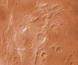 The crater Srīpur and its surroundings, in a screenshot in NASA World Wind. | |
| Planet | Mars |
|---|---|
| Coordinates | 31.1°S 100.8°W |
| Diameter | 22.99 km |
| Eponym | Srīpur, a town in Bangladesh |
According to a surface age map of Mars based on US Geological Survey data, the area around Srīpur is from the Noachian epoch, which places the area's age at 3.8 to 3.5 billion years ago.[3] The crater floor is relatively flat, except for a small craterlet toward east of the center, and is approximately 6,300 meters above zero altitude in elevation. Its rim averages about 6,800 meters above zero altitude, making it 500 meters deep. The area south of the crater is about the same elevation as the crater floor.[2]
References
- "Gazetteer of Planetary Nomenclature – Srīpur". usgs.gov. Working Group for Planetary System Nomenclature – International Astronomical Union. Retrieved 10 August 2017.
- NASA World Wind 1.4. NASA Ames Research Center, 2007.
- "INTEGRATING GLOBAL-SCALE MISSION DATASETS – UNDERSTANDING THE MARTIAN CRUST" (PDF). lpi.usra.edu. 2005. Retrieved 10 August 2017.