Cerberus Fossae
The Cerberus Fossae are a series of semi-parallel fissures on Mars formed by faults which pulled the crust apart in the Cerberus region. They are 1235 km across and centered at 11.28 °N and 166.37 °E. Their northernmost latitude is 16.16 °N and their southernmost latitude 6.23 °N. Their easternmost and westernmost longitudes are 174.72 °E and 154.43 °E, respectively. They can be seen in the Elysium quadrangle.[1]
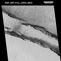 Closeup of several Cerberus Fossae troughs, as seen by HiRISE (scale bar is 1.0 km) | |
| Coordinates | 11.9°N 188.8°W |
|---|---|
| Length | 1,630.0 km |
| Naming | From albedo feature at 10n, 212W. Changed from Cerberus Rupes. |
Ripples seen at the bottom of the faults are sand blown by the wind.[2] Numerical modeling of the forces in the crust of Mars suggest that the underlying cause for the faulting is the deformation caused by the Tharsis volcanoes to the east. The faults are quite young, cutting through pre-existing features such as the hills of the Tartarus Montes and the lava apron southeast of Elysium Mons.[3] The formation of the fossae was suspected to have released pressurized underground water, previously confined by the cryosphere, with flow rates up to 2 × 10⁶ m3s−1, leading to the creation of the Athabasca Valles.[4][5][6] Marte Vallis is another channel that was suggested to have formed from water released from Cerberus Fossae.[7] Crater counts suggest this last outflow from the Cerberus Fossae took place about 2 to 10 million years ago.
There has been a suggestion such high discharges of water to the surface through these fissures are physically implausible and that lava was the fluid erupted from the Cerberus Fossae. The flood of lava would have had a volume of about 5000 cubic kilometers, quite typical of flood basalt eruptions on Earth. At these high discharges, lava behaved in many ways like a flood of water. It appears to have modestly eroded parts of the Athabasca Valles and then filled the Cerberus Palus basin. The rafted plates of lava in this 800 km (500 mi) by 900 km (560 mi) temporary lava pond are remarkably similar in appearance to pack ice seen in the North Sea.[8]
While some of the cracks are situated at the top of a topographic rise and are surrounded by flow features, indicating they served as volcanic vents, others are on completely flat terrain without flow features, indicating they are simply fractures.[9]
The Cerberus Fossae area has been positively identified as the first tectonically active region on Mars, with marsquakes being geolocated there by seismometer measurements from the NASA InSight lander in 2019;[10][11][12][13] this activity was previously suspected on the basis of the trails of dislodged boulders.[14][15]
Gallery
 THEMIS mosaic of the Cerberus Fossae region. The Athabasca Valles outflow channels emerge from fissures at lower left. (The large image may be more easily viewed at full resolution with ZoomViewer.)
 One of the Cerberus Fossae, as seen by THEMIS
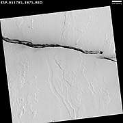 Wind-blown material darkens areas around a Cerberus Fossae trough (scale bar for HiRISE image is 500 m)
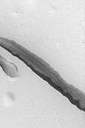 A 3 km section of a Cerberus Fossae fissure, taken by the Mars Global Surveyor (MGS) Mars Orbiter Camera (MOC)
 Angular unconformity in the Cerberus Fossae, as seen by HiRISE (click on image to see the angles of the layers)
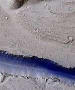 Portion of a trough (fossa) in Elysium, as seen by HiRISE under the HiWish program (blue indicates probably seasonal frost)
See also
- Fossa (geology)
- Geology of Mars
- HiRISE
- HiWish
- Lakes on Mars
References
- "Cerberus Fossae". Gazetteer of Planetary Nomenclature. USGS Astrogeology Science Center. Retrieved 2018-05-07.
- "Cerberus Fossae Trough". Nasa.gov. Nasa. Retrieved 19 April 2014.
- "Cerberus Fossae". Asu.edu. Arizona State University. Retrieved 19 April 2014.
- James W. Head; Lionel Wilson; Karl L. Mitchell (2003). "Generation of recent massive water floods at Cerberus Fossae, Mars by dike emplacement, cryospheric cracking, and confined aquifer groundwater release". Geophysical Research Letters. 30 (11): 2265. Bibcode:2003GeoRL..30.1577H. doi:10.1029/2003GL017135.
- Cabrol, N. and E. Grin (eds.). 2010. Lakes on Mars. Elsevier. NY
- Burr, D. et al. 2002. Repeated aqueous flooding from the Cerberus Fossae: evidence for very recently extant deep groundwater on Mars. Icarus. 159: 53-73.
- Gareth, A. B. Campbell, L. Carter, J. Plaut, R. Phillips. 2013. 3D Reconstruction of the Source and Scale of Buried Young Flood Channels on Mars. Science, March 7, DOI:10.1126/Science.1234787
- Young, Kelly (2005-02-25). "'Pack ice' suggests frozen sea on Mars". New Scientist. Retrieved 2007-01-30.
- Lakdawalla, E. (2010-07-12). "3D Anaglyph: Troughs or vents in Cerberus Fossae?". www.planetary.org/blogs. The Planetary Society. Retrieved 2019-12-17.
- Witze, A. (2019). "'Marsquakes' reveal red planet's hidden geology". Nature. 576 (7787): 348–348. doi:10.1038/d41586-019-03796-7.
- Banerdt, W.B.; Smrekar, S.E.; Banfield, D.; et al. (2020). "Initial results from the InSight mission on Mars". Nature Geoscience. doi:10.1038/s41561-020-0544-y.
- Giardini, D.; Lognonné, P.; Banerdt, W. B.; et al. (2020). "The seismicity of Mars". Nature Geoscience. doi:10.1038/s41561-020-0539-8.
- Golombek, M.; Warner, N. H.; Grant, J. A.; et al. (2020). "Geology of the InSight landing site on Mars". Nature Communications. 11 (1). doi:10.1038/s41467-020-14679-1.
- Roberts, G.P.; Matthews, B.; Bristow, C.; Guerrieri, L.; Vetterlein, J. (2012). "Possible evidence of paleomarsquakes from fallen boulder populations, Cerberus Fossae, Mars". Journal of Geophysical Research: Planets. 117 (E2): E02009. doi:10.1029/2011JE003816.
- Brown, J.R.; Roberts, G.P. (2019). "Possible Evidence for Variation in Magnitude for Marsquakes From Fallen Boulder Populations, Grjota Valles, Mars". Journal of Geophysical Research: Planets. 124 (3): 801–822. doi:10.1029/2018JE005622.