Southern Andean Volcano Observatory

The Southern Andean Volcano Observatory (Spanish: Observatorio Volcanológico de los Andes del Sur), also known by its acronyms as OVDAS, is part of Red Nacional de Vigilancia Volcánica, a program of the Chilean National Geology and Mining Service to watch the 43 most dangerous volcanoes of Chile. 2012 there were 30 volcanos under observation.[1]

This is a list of the volcanoes with activity reports made by the OVDAS.[2][3]

Name Last eruption Region Coordinates OVDAS webpage
Isluga96000±6000 years BPTarapacá19°07′S 68°49′W
San Pedro1960Antofagasta21°53′S 68°24′W
Lascar1993Antofagasta23°22′S 67°54′W
Tupungatito1959-60Metropolitana33°23′S 69°48′W
San José1932-33Metropolitana33°47′S 69°53′W
Tinguiririca1917O'Higgins34°49′S 70°20′W
Planchón-Peteroa2010Maule35°14′S 70°34′W
Descabezado G.1932-33Maule35°35′S 70°44′W
San Pedro de Tarara96000±6000 years BPMaule36°00′S 71°50′W
Nevado de LongavíHolocenoMaule36°12′S 71°10′W
Laguna del Maule3000 years BPMaule36°59′S 70°35′W
Nevados de Chillán1973Biobío36°51′S 71°24′W
Antuco1853Maule37°24′S 71°21′W
Copahue1992Biobío37°52′S 71°10′W
Callaqui1980Biobío37.92°S 71.45°W / -37.92; -71.45
Lonquimay and Tolhuaca1990Araucanía38°23′S 71°35′W
Llaima2009Araucanía38°41′S 71°44′W
Sollipulli1240 A.D.Araucanía38°59′S 71°31′W
Villarrica2010Araucanía, Los Ríos39.42°S 71.93°W / -39.42; -71.93
Quetrupillán1650±70 BPAraucanía, Los Ríos39.5°S 71.7°W / -39.5; -71.7
Lanín2170±70 years BPAraucanía, Los Ríos39.7°S 71.5°W / -39.7; -71.5
Mocho-Choshuenco1864Los Ríos39°55′S 72°02′W
Carrán-Los Venados1955 ADLos Ríos40.35°S 72.07°W / -40.35; -72.07
Puyehue-Cordón Caulle2011Los Ríos, Los Lagos40°31′S 72°12′W
Antillanca-Casablanca2910 ± 150 years BPLos Lagos40.77°S 72.22°W / -40.77; -72.22
Osorno1869Los Lagos41°06′S 72°30′W
Calbuco2015Los Lagos41.32°S 72.60°W / -41.32; -72.60
Yate and Hornopirén?Los Lagos41°46′S 72°24′W
Michinmahuida17th century?Los Lagos42°48′S 72°26′W
Chaitén2008Los Lagos42°50′S 72°39′W
Corcovado and
Yanteles
6870±90 BPLos Lagos43°11′S 72°47′W
Macá9000 years BPAysén45°06′S 73°10′W
Melimoyu200 AD ± 75 yearsAysén44°05′S 72°53′W
Mentolat1850?Aysén44.70°S 73.08°W / -44.70; -73.08
Hudson1991Aysén45°54′S 72°58′W
Llaima's 2008 eruption as viewed from Temuco

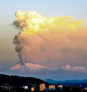
The headquarters are at Cerro Ñielol at Temuco from where there is good sight to Llaima and Villarrica, two of Chile's most active volcanoes. Much of the OVDAS work is made in collaboration with CONAF that administers the national parks and reserves where many volcanoes are located. The regional government of Araucanía Region also contributed to the project.

See also

References

  1. Observatorio Volcanológico de Los Andes del Sur (OVDAS) Archived 2013-10-29 at the Wayback Machine, retrieved on 28 October 2013
  2. "OVDAS-SERNAGEOMIN: Informes, Reportes y Otros Informes". Archived from the original on 2011-07-03.
  3. Red de vigilancia volcánica Archived 2016-11-28 at the Wayback Machine, retrieved on 28 October 2013
This article is issued from Wikipedia. The text is licensed under Creative Commons - Attribution - Sharealike. Additional terms may apply for the media files.