Sara Sara
Sara Sara[2][3] is a 5,505-metre-high (18,061 ft)[2][3] volcano lying between Lake Parinacochas and Ocoña River in Peru.[2] It is situated in the Parinacochas Province, Puyusca District, and in the Paucar del Sara Sara Province, in the districts of Pausa and Sara Sara.[4]
| Sara Sara | |
|---|---|
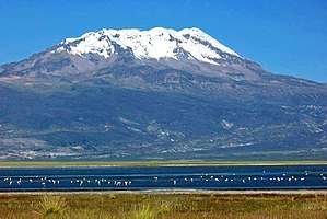 Sara Sara and Lake Parinacochas in front of it | |
| Highest point | |
| Elevation | 5,505 m (18,061 ft) |
| Prominence | 2,060 m (6,760 ft) [1] |
| Listing | Ultra |
| Coordinates | 15°19′46″S 73°26′41″W |
| Geography | |
 Sara Sara Peru, Ayacucho Region | |
| Parent range | Andes |
Geography and geomorphology
Sara Sara lies in the Parinacochas and Paucar del Sara Sara Provinces of the Ayacucho Region, Peru.[5] The town of Pausa lies 12 kilometres (7.5 mi) away from the volcano, and agriculture occurs in the valleys of the area.[6] The mountain was worshipped by local populations in and before Inca time, and the Inca performed human sacrifices on it.[7]
The volcano is 5,505 metres (18,061 ft) high.[8] It consists of a complex of lava domes and lava flows superposed on older stratovolcanoes.[9] The vents are aligned in north-northeast-south-southwest direction and are accompanied by lateral lava domes. These vents were the source of lava flows and block-and-ash flows generated by the collapse of lava domes.[10] A pyroclastic cone of recent age is found on the mountain.[11] Glacial cirques are found on Sara Sara's western and eastern flanks.[12]
Geology
Sara Sara is the northernmost volcano of the Central Volcanic Zone of the Andes.[9]
The volcano is part of a 30 kilometres (19 mi) long, fault-controlled chain of volcanoes, which includes Cerro Grande, Yarihuato, Puca Ccasa, Sara Sara, Puca Puca and Cerro Queñuapunco.[9]
The basement is formed by Precambrian and Paleozoic rocks, which are covered by Mesozoic and Cenozoic sediments and volcanites.[9]
During its history, Sara Sara has produced andesite, dacite and trachyandesite, with dacite predominating during Quaternary eruptions.[5] Phenocrysts in the rocks include hornblende and plagioclase, and both their quantity and chemistry varied between various stages of activity.[13]
Quaternary moraines and Holocene active and inactive rock glaciers have been described and mapped[14] showing two distinct stages with snow line depression of 3-400 and 600 m compared to the present respectively.
Climate
The climate shows altitudinal zonation, with temperatures ranging from 20–6 °C (68–43 °F) in the valleys to freezing temperatures above 5,200 metres (17,100 ft). Precipitation is seasonal and mostly falls during summer, at higher elevations in the form of hail and snow.[15]
Trees grow at lower elevations, while only ichu and quinua are present above 4,000 metres (13,000 ft). Alfalfa and maize are cultivated at lower altitudes.[15]
Eruption history
Sara Sara was active in the form of the lower Barroso and Lampa Volcanics.[5] A first stage built up the paleo-Sara Sara edifice in the form of columnar jointed lava flows; a date obtained on this stage is 1.62 million years ago. The Lampa Volcanics were erupted by lateral vents northeast of the volcano and later buried by its eruption products and exposed by the Huanca Huanca river.[10] During the Quaternary, explosive eruptions in a lava dome complex formed a pyroclastic fan which was later in part buried by lava flows.[5] Fresh lava and pyroclastic flows imply recent activity,[6] with two pyroclastic flows dated to 44,500 and 49,200 years before present.[16]
Sara Sara is currently classified as a dormant volcano. Future eruptive activity could generate lahars, lava flows, Plinian eruption deposits and pyroclastic flows.[5] Aside from Pausa, other towns and Lake Parinacochas (an important source of water for the region) are located close to the volcano.[6]
Hot springs are found northeast of Sara Sara in the Quilcata valley and close to the town of Chacaraya, implying the presence of a shallow magma chamber.[6]
Archeology
The Spanish priest Cristobal de Albornoz noted in 1583 that Sara Sara was one of the most important sacred places in the southern part of Peru, with 2,000 colonists sent by the Inca emperor for its service. The American archaeologist Johan Reinhard surveyed a site on its summit in 1983 and he and Peruvian archaeologist Jose Antonio Chavez led a team that uncovered more than a dozen statues and a female Inca mummy (later nicknamed Sarita) on the summit in 1996. Their expedition was transmitted "live" over the Internet.[17] The findings made on Sara Sara are currently stored at the Museo de Santuarios Andinos in Arequipa.
The archaeological group of Sara Sara was recommended to be declared a National Cultural Heritage in 2003.[18]
 Sara Sara and Lake Parinacochas (foreground) as seen from Inka Wasi
Further reading
Reinhard, Johan (2005). The Ice Maiden: Inca Mummies, Mountain Gods, and Sacred Sites in the Andes. Washington, D.C.: National Geographic Society. ISBN 0-7922-6838-5.
See also
References
- Sara Sara on Peakbagger.com
- Peru 1:100 000, Pausa (31-p). IGN (Instituto Geográfico Nacional - Perú).
- Biggar, John (2005). The Andes: A Guide for Climbers. Andes. p. 108. ISBN 9780953608720.
- escale.minedu.gob.pe - UGEL map of the Parinacochas Province (Ayacucho Region)
- Morche & Núñez Juárez 1998, p. 1.
- Morche & Núñez Juárez 1998, p. 3.
- Schreiber, Katharina (1 January 2004). "Sacred Landscapes and Imperial Ideologies: The Wari Empire in Sondondo, Peru". Archeological Papers of the American Anthropological Association. 14 (1): 137. doi:10.1525/ap3a.2004.14.131. ISSN 1551-8248.
- Morche & Núñez Juárez 1998, p. 4.
- Morche & Núñez Juárez 1998, p. 9.
- Morche & Núñez Juárez 1998, p. 10.
- Morche & Núñez Juárez 1998, pp. 3-4.
- Morche & Núñez Juárez 1998, p. 7.
- Morche & Núñez Juárez 1998, p. 19.
- Dornbusch U (1997) Geomorphological investigations on the late glacial glaciation in the western Andes of South Peru between 14°25’S and 15°30’S, inferable climatic conditi ons and their comparison with newly compiled data on the recent distribution of temperature, precipitation and snowline altitudes in south Peru south of 12°S. (translated title).PhD (Dr rer nat). Freie Universitaet Berlin, Berlin. Available at: DOI: 10.13140/RG.2.2.15202.48329. https://www.researchgate.net/publication/261099272_Geomorphological_investigations_on_the_late_glacial_glaciation_in_the_western_Andes_of_South_Peru_between_1425'S_and_1530'S_inferable_climatic_conditi_ons_and_their_comparison_with_newly_compiled_data
- Morche & Núñez Juárez 1998, pp. 5-6.
- Juvigné, Etienne; Thouret, Jean-Claude; Loutsch, Isabelle; Lamadon, Sébastien; Frechen, Manfred; Fontugne, Michel; Rivera, Marco; Dávila, Jasmine; Mariño, Jersy (1 June 2008). "Retombées volcaniques dans des tourbières et lacs autour du massif des Nevados Ampato et Sabancaya (Pérou méridional, Andes Centrales)". Quaternaire (in French). 19 (2): 159. doi:10.4000/quaternaire.3362. ISSN 1142-2904.
- "NOVA Online | Ice Mummies of the Inca".
- El Peruano, Normas Legales, p. 243765, May 8, 2003, Lima
Sources
- Morche, Wolfgang; Núñez Juárez, Segundo (1998). "Estudio del riesgo geológico del volcán Sara Sara. Proyecto Estudio del Riesgo Volcánico e Hidrotermalismo en el sur del Perú" (PDF). Instituto Geológico, Minero y Metalúrgico - Ingemmet (in Spanish). Retrieved 10 March 2018.CS1 maint: ref=harv (link)