Michinmahuida
Michinmahuida (Spanish pronunciation: [mitʃinmaˈwiða]) (alternate spellings Minchinmávida or Michimahuida) is a glaciated stratovolcano located in Los Lagos Region of Chile. It lies about 15 km east of Chaitén volcano, and was extensively covered in ash during the 2008 eruption of Chaitén.[2] The stratovolcano lies above the regional Liquine-Ofqui Fault zone, and the ice-covered massif towers over the south portion of Pumalín Park. It has a summit elevation of 2,450 meters above sea level.
| Michinmahuida | |
|---|---|
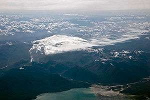 The volcano is visible in the center of this image, right behind the ash column of the Chaitén volcano in eruption. | |
| Highest point | |
| Elevation | 2,450 m (8,040 ft) [1] |
| Prominence | 1,518 m (4,980 ft) [1] |
| Listing | Ultra |
| Coordinates | 42°47′57″S 72°26′45″W [1] |
| Geography | |
 Michinmahuida | |
| Parent range | Andes |
| Geology | |
| Mountain type | Stratovolcano |
| Last eruption | February to March 1835 |
References
- "Argentina and Chile, Southern: Patagonia Ultra-Prominences" Peaklist.org. Retrieved 2012-04-16.
- http://earthobservatory.nasa.gov/NaturalHazards/view.php?id=37323
Sources
This article is issued from Wikipedia. The text is licensed under Creative Commons - Attribution - Sharealike. Additional terms may apply for the media files.