Sirsi, Karnataka
Sirsi is a City elevated about 2,600 ft (790 m) above sea level in the Indian state of Karnataka. Sirsi was also known as Kalyanapattana[1] during the Sonda Dynasty. Sirsi is also known as "Gate of Malenadu" or "ಮಲೆನಾಡಿನ ಹೆಬ್ಬಾಗಿಲು" in Kannada
SIRSI "ಮಲೆನಾಡಿನ ಹೆಬ್ಬಾಗಿಲು" | |
|---|---|
City
name = Sirsi | |
 Clockwise from Top Right- Bheemanavra Gudda Peak, Yana Rock Mountain, Madhukeshwara Temple - Banavasi, Unchalli Falls, Marikamba Fair-Largest fair in Karnataka, Agnhashini river, Shasralinga, Devimane Ghat view point | |
 SIRSI Location in Karnataka, India | |
| Coordinates: 14.6195°N 74.8354°E | |
| Grid position | MK74 |
| Country | |
| State | Karnataka |
| Köppen climate classification | Am / Tropical monsoon climate |
| District | Uttara Kannada |
| Region | Malenadu, Western Ghats, Canara |
| Nearest International Airport | Dabolim Airport, Goa |
| Forest Classification | Tropical Evergreen forest, Semi-Evergreen, Wet Decidious Forest |
| Government | |
| • Body | City Municipal Council |
| • MLA | Vishweshwar Hegde Kageri |
| • MP | Anant Kumar Hegde |
| Area | |
| • City name = Sirsi | 11.2 km2 (4.3 sq mi) |
| • Urban | 11.2 km2 (4.3 sq mi) |
| • Rural | 3,695 km2 (1,427 sq mi) |
| Elevation | 800 m (2,600 ft) |
| Population (2018) | |
| • City name = Sirsi | 186,908 |
| • Density | 17,000/km2 (43,000/sq mi) |
| Languages | |
| • Official | Kannada |
| Time zone | UTC+5:30 (IST) |
| PIN | 581401, 581402, 581403 |
| Telephone code | +91-8384 |
| Vehicle registration | KA-31 |
| Literacy | 92.82% |
| Website | www |
Sirsi is a tourist destination with a population of 155,079 (as per 2018 election votes). It is the largest city, a main commercial centre and a business hub in Uttara Kannada district. The city is surrounded by forest, and the region has a number of waterfalls. The main businesses around the city are mostly subsistence and agriculture based. Adike (also known as supari, areca nut or betel nut) is the primary crop grown in the villages that surround the city, making it one of the major trading centres for areca nut. The region is also known for spices such as cardamom, pepper, betel leaves, and vanilla. The major food crop is paddy.
Geography
Sirsi is located at 14.62°N 74.85°E (Grid Square MK74).[2] It has an elevation ranging between 1860 feet to 2600 feet above sea level, and is situated in the heart of the Western Ghats. Sirsi is about 425 kilometres (264 mi) from Bangalore. The nearest airport is located in Hubli, about 102 km (63 mi) from Sirsi. River Aghanashini begins at a place near Sirsi called "Donihalla" and flows towards the Arabian Sea in the west. The river also creates many waterfalls along its path.
Climate
The climate in Sirsi is strongly influenced by the monsoons, and the climate is tropical, moderated by proximity to the sea. During monsoons, the region receives one of the heaviest rainfall in the world. As a result, the region also has a large variety of wildlife. The vegetation in the region is mainly moist deciduous, and valuable timber wood is commonly found in the forests of this region. Owing to the rich flora and fauna, deforestation and poaching have been causes for concern in recent years. The climate of Sirsi is moderate and pleasant throughout the year with high humidit and with winter temperatures dropping below 15 °C (59 °F). The highest temperature recorded here was 40.2 °C (104.4 °F), and the lowest was 2.4 °C (36.3 °F).
| Climate data for Sirsi,KA,India (1961-2010) | |||||||||||||
|---|---|---|---|---|---|---|---|---|---|---|---|---|---|
| Month | Jan | Feb | Mar | Apr | May | Jun | Jul | Aug | Sep | Oct | Nov | Dec | Year |
| Average high °C (°F) | 28 (82) |
30 (86) |
31 (88) |
33 (91) |
35 (95) |
25 (77) |
23 (73) |
25 (77) |
27 (81) |
30 (86) |
28 (82) |
27 (81) |
29 (83) |
| Average low °C (°F) | 14 (57) |
16 (61) |
17 (63) |
20 (68) |
21 (70) |
20 (68) |
19 (66) |
19 (66) |
20 (68) |
20 (68) |
18 (64) |
15 (59) |
18 (65) |
| Record low °C (°F) | 2.4 (36.3) |
4.4 (39.9) |
7.1 (44.8) |
9.4 (48.9) |
9.7 (49.5) |
8.7 (47.7) |
7.1 (44.8) |
9.4 (48.9) |
9.3 (48.7) |
8.2 (46.8) |
4.9 (40.8) |
3.1 (37.6) |
2.4 (36.3) |
| Average rainfall mm (inches) | 4 (0.2) |
6.1 (0.24) |
12 (0.5) |
30 (1.2) |
104.3 (4.11) |
1,235.4 (48.64) |
2,020.1 (79.53) |
1,078.2 (42.45) |
395.5 (15.57) |
179.5 (7.07) |
47 (1.9) |
28 (1.1) |
5,140.1 (202.51) |
| Average rainy days | 1 | 4 | 9 | 10 | 12 | 28 | 30 | 29 | 17 | 14 | 3 | 1 | 158 |
Source: Skymet Observatory
"Climatological Information for Sirsi,India",} | |||||||||||||
Climate in Sirsi Taluk
Sampakhanda , Kakkali, Devimane Ghat, Bandla, Hebre are nearby and under Sirsi Taluk. Sampakhanda is the coldest place where the temperature would drop below 20°C often during winter season and often drops below 25°C even in summer season, and it had been recorded coldest not only in Uttara Kannada district but also as the coldest place among Karnataka especially during summer season.
Demographics
As of 2011,[3] the population of Sirsi within town limits was 62,335. Males constituted 51% of the population and females 49%. Sirsi had an average literacy rate of 92.82%, which was much higher than the national average of 74.05%. Male literacy was 95.26%, and female literacy 90.43%. About 12% of the population was under 6 years of age. In Sirsi City Municipal Council, the female sex ratio was 1014, whereas the state average in Karnataka was 973.
The major castes living in of Sirsi include: Havyaka Brahmin, Namadhari Naik, Madivala, Kuruba,[Goud Saraswat Brahmin]], Lingayat, Nadava, Rama Kshatriya, Shervegar Nayak, Gudigar, Daivajna and Ganiga.
The Havyaka Brahmins of Sirsi speak the Havyaka Kannada dialect of Kannada. The Goud Saraswat Brahmin, Daivajna and Gavli castes, which form a sizeable part of the population and Christians speak Konkani. The Muslims of Sirsi speak both Kannada and Urdu.
Access
By road
Sirsi is linked to other parts of the state many state highways. Couple of National Highways are sanctioned by the Ministry of Transport, Government of India passing through Sirsi namely Yellapur-Sirsi-Talguppa and Kumta-Sirsi-Haveri which will be developed and maintained by National Highways Authority of India (NHAI). Sirsi is linked to neighboring district headquarters of Dharwad, Mangalore, Udupi, Haveri, Belagavi and Shimoga. The state corporation has a network of buses to all major cities and towns in Karnataka, Maharashtra and Goa. VRL, SRS, Seabird, Shreekumar Travels, Durgamba Travels, Sri Durgamba Travels and Sugama Transport are the major private bus operators. Premium Volvo and Corona bus services are also available.
There are 3 mountain roads otherwise known as Ghat section are available to access Sirsi,
1. Devimane Ghat Road from Kumta via Katgal, Devimane, Amminali,
Total Number of Hairpin turn : 15
2. Vaddi Ghat Road from Ankola via Achave, Yana Rock Mountain, Devanahalli,
Total Number of Hairpin turn : 21
3. Doddamane Ghat Road from Kumta via Mavingundi, Siddapura, Kansoor,
Total Number of Hairpin turn : 15
Some roads might be dangerous to access during monsoon seasons because of slippery conditions. But these are scenic route during June, July, August, September, October months because of monsoon.

By train
The nearest railhead is at Talguppa and Kumta. Talguppa is 54 km (34 mi) from Sirsi. Kumta is 62 km (39 mi) from Sirsi. Haveri Railway Station is about 76 km (47 mi) from Sirsi and it has rail network to some major cities like Hubli , Davangere, Bangalore, Mumbai, Pune, Salem, Madurai, Tirunelveli.Talguppa railway connects Bengaluru city via Sagara, Shimoga District. Kumta railway connects Kochi and Mumbai via Mangaluru and Karwar, respectively. The major railhead is Hubli, which is the Zonal Headquarters of South Western Railways.
By air
The nearest airport is in Hubli, and the other is Belgaum, which are about 2.5 hrs and 5 hours drive from Sirsi respectively. Belgaum is connected to Bangalore, while Hubli is connected to Bangalore (Direct - Four Flights Daily), Mangalore (1 stop same equipment), Chennai (Direct), Jabalpur (1 stop same equipment) and Mumbai (Direct - Twice Daily) by air. The nearest International Airport is Dabolim Airport, Goa.
Art and culture
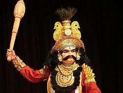
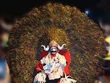
Yakshagana is a classical dance drama common to the state of Karnataka mainly in the districts of Uttara Kannada, Shivamogga, Udupi, Dakshina Kannada and Kasaragod district of Kerala. There are several Yakshagana artists in and around Sirsi and it is being regularly played in Sirsi. Traditionally, Yakshaganas used to start late in the night and run entire night. Bhagavatha along with background musicians who play Chande and Maddale forms himmela. The actors who wear colorful costumes and enact various roles in the story forms Mummela. Yakshagana is sometimes simply called as Aataā in both Konkani and Kannada (meaning play).[4] Yaksha-gana literally means the song (gana) of a Yaksha. Yakshas were an exotic tribe mentioned in the Sanskrit literature of ancient India.[5]
In Sirsi, Holi is celebrated with a unique Carnival. Folk dance called "Bedara Vesha" is performed during the nights beginning five days before the actual festival day. The festival is celebrated every alternate year in the town which attracts a large crowd on all the five days from different parts of the India.[6]
Dollu Kunitha is also another folk dance of Sirsi performed during Bedara Vesha and Marikamba Fair.
Media and Communications
- Telephones
- BSNL provides the landline telephone services and is widely used.
- Radio
- Dharwad AIR station can be heard on 765 kHz Medium Wave and Dharwad Vividha Bharathi can be heard on 103 MHz FM. Additionally private FM stations - Red FM(93.5 MHz) and Radio Mirchi(98.3 MHz) aired from Hubli can be heard in Sirsi.
- Amateur radio
- QRZ.COM lists two amateur radio operators in Sirsi using the ITU prefix VU2/VU3.
- Television
- Sirsi has LPT-49 TV relay station airing Doordarshan National Channel. Cable TV and Direct to Home services are widely used and these have replaced the conventional VHF/UHF TV antennas and satellite dish antennas, Sirsi.info TV.
- Internet
- BSNL Broadband provides fixed-line internet service.
- Mobile phone services
- Majority of the mobile networks have coverage only in city limits. BSNL mobile has coverage in the rural parts. Airtel, BSNL, Vodafone networks provide 3G data services. Vodafone,Airtel, Jio, Idea and Reliance communications provide 4G LTE services.
- Newspapers
- Vijaya Karnataka, Prajavani, Samyukta Karnataka, Vishwavani, Udayavani and The Times of India (all published from Hubli) are the major newspapers in the area. Patrakartha, Janamadhyama, Lokadwani & Sirsi Siri are the local papers. Lokadwani can also be accessed on the Internet http://lokadwani.com & Janamaadhyama Newspaper, Nuthana TV, Sumukha TV Available in http://www.sirsi.info
Sirsi Supari
Arecanut is extensively grown in this region. The arecanut grown in Sirsi has unique features like a round and flattened coin shape, particular texture, size, cross-sectional views, taste, etc. Its average dry weight is 7.5 g and average thickness is 16 mm. This unique arecanut has secured a GI tag.'[7]
Budget information
The annual budget of the CMC Sirsi for the year 2009–10 was Rs.1534.28 lakhs, out of which Rs.781.20 lakhs was proposed for capital expenses, Rs.462.45 lakhs towards proposed revenue payment, Rs.232.09 lakhs towards extra ordinary payment, and for development of SC&ST was Rs.9.86 lakhs.[8]
Special and sweet dishes of Sirsi
- Todadevu is a special kind of thin-crust dosa made out of fresh sugarcane juice. (Most local desserts of Sirsi have jaggery rather than sugar.)
- Kadubu: The main ingredients are jackfruit pulp and jaggery. The batter is prepared and, with additional ingredients, the batter is put into a container and steamed. The dessert is a local delicacy and is served hot with ghee butter.
- Karakali is a special kind of chutney which tastes very spicy. It is prepared from colocasia leaves.
- Kesari is a special sweet prepared from special small aromatic rice Sannakki, saffron and ghee. It is generally prepared during marriage ceremonies.
- Shunti Kaddi is a special sweet prepared from ginger paste and jaggery, which is most popular during Sirsi Jathre.
- Bendu Battasu is a special sweet which is available during Sirsi Jathre.
Religious places

Shri Marikamba Temple
Sirsi's Marikamba temple was built in 1688 and renovated at periodic intervals. The 'Marikamba Jaathre', commemorating the goddess Marikamba, is held by the temple authorities every alternate year. Nearly a lakh (100,000) Hindu devotees from all parts of the country attend the fair, making it one of the biggest festivals in South India.
Shri Swarnavalli Maha Samsthana
Shree Matha is situated amidst evergreen forests near Shalmala river in Sirsi Taluk of Uttara Kannada district. It's history can be traced back to the period of Adi Shankaracharya who professed Advaita philosophy and established Mathas to propagate it.It is a famous religious center and includes 16 seemas in the Upperghat and several places in the Lowerghat and many more disciples across India. Havyaka Brahmins, Ramakshatriyas, Sheeligas, Siddhis, Marathis, Goulis, Bhandaris and Kunbis and many more are the traditional deciples of this matha.
Sodhe or Sonda or Swadi flourished during the Vijayanagara Empire and is a considered to be a sacred place by both Hindus and Jains. Sonda is known for Shri Vadiraja Matha, Shri Swarnavalli Matha and is about 15 km (9.3 mi) from Sirsi.[9][10]
Shri Kshetra Manjuguni
Sri Kshetra Manjuguni is one of the popular pilgrim centers located in the Uttara Kannada (North Canara) district of Karnataka state. This place is located at a distance of 26 km from Sirsi.The temple here is dedicated to Lord Venkataramana and Goddess Padmavathi. Devotees believe that, Manjuguni is called as "Tirupati of karnataka".The temple is situated in western ghat belt, popularly known as Sahyadri hills. During winter, this place is covered by thick fog (in Kannada: Manju) and hence it is called by the name "Manjuguni". The temple of Lord Venkatramana is a huge complex built in Vijayanagara Style.
According to "Sri Venkatesha Mahatmya" the founder of this temple is "Sri Tirumala Yogi" a saint.
Jain Matha
A Jain Matha exists there, and it has been headed by Bhattaraka Swasti Sri Bhattakalanka.[11][12][13] The Sonda Jain Matha is also known as the Swadi Jain Matha.[14]
Churches
St. Anthony's church is in Sirsi and is situated in the center of the town, and is the main church for the minority Christian population in the region. Another church is St. John Bosco Church situated on Hubli Road. Another church is Infant Jesus Church in Agasebagil. St.Paul's Mar Thoma Church is situated near the Zoo Circle.
Prominent places in and around the Taluk of Sirsi
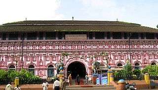
- Banavasi, the capital of an ancient kingdom in Karnataka (state) ruled by the Kadamba Dynasty is 24 km away from the Sirsi town center. Banavasi is considered as the "first" capital of Karnataka state, with the current capital being Bangalore. Although most of the ancient grandeur of the dynasty in Banavasi has been lost, an ancient temple for Madhukeshwara (Lord Shiva) is still largely intact, and has been declared a monument of historical importance by the Archaeological Survey of India.
- Sahasralinga (Sanskrit for a thousand Shiva (deity) lingas) is another place of significance, where Shiva's sculptures carved out of stones thousands of years ago can be found in the middle of a flowing river. The river is surrounded by lush green forest; the place is about 10 km from the town center. The place is quite secluded, except during "Maha Shivaratri" celebrations, when it receives a huge number of pilgrims from the surrounding areas.
- Sonda, known for its Sri Vadiraja Matha, and Swarnavalli Mutt are about 15 km (9.3 mi) away from Sirsi.
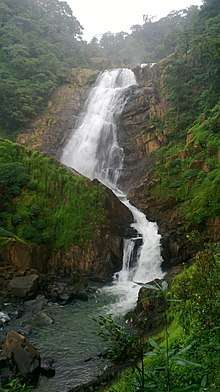
- Unchalli Falls, (also known as Keppa Joga, referring to the other waterfall nearby, Jog falls) is situated about 30 km (19 mi) from Sirsi, and is one of the biggest tourist attractions near Sirsi. The waterfall is a 116-meter drop (381 ft).
- Yana, known for the unusual rock formation. It is located 40 kilometres (25 mi) from Sirsi.
Other destinations
- Shivaganga Falls
- Burude Falls
- Benne Hole Falls
- Pancha Linga
- Ganesh Paalu
- Mattighatta Falls
- Waate Halla Falls
- Duggumane Falls
- Kumbri Gudda
- Dhoranagiri
- Musukina Bavi
- Manjaguni Devasthana
- Jog Falls (Sagara, Shimoga District Taluk)
- Tapovan – a sacred place of Shri Vadiraja swami
- Banagere Falls
- Nishane Gudda
- Unchalli Falls
- Vibhuthi Falls
- Sathodi Falls
- Sahasralinga
- Magod Falls
- Bhimana Gudda
- Goli Siddivinayaka Temple
- Kashikalyana gudda Tuduguni
- Jenkal Gudda Yellapura
- Chandragutti (Good for trekking)
Nature and terrain
Sirsi is a destination for trekkers and nature lovers alike, owing to its location in the middle of the Western Ghats. Many viewpoints and mountain peaks provide extensive views of the Sahyadri mountain ranges. Nishane Gudda (785m), Jennukal Gudda (670m), Kailasa Gudda (690m), Kumbri Gudda (797m) and Motigudda (834m) are one among the extensive sahayadri view points here. The Region is ruled by Dense Tropical Evergreen Forest owing home to many wild animals like Tigers and Black Panther.
Notable people from Sirsi
- Mayurasharma- Founder of Kadamba dynasty
- Adikavi Pampa- First Poet of Kannada
- Nandan Nilekani- an Indian entrepreneur
- Hardekar Manjappa- social reformer, writer and journalist, Gandhi of Karnataka.
References
- "Kalyanapattana".
- "Maps, Weather, and Airports for Sirsi, India". fallingrain.com. Retrieved 13 August 2015.
- "Census of India 2001: Data from the 2001 Census, including cities, villages and towns (Provisional)". Census Commission of India. Archived from the original on 16 June 2004. Retrieved 1 November 2008.
- "Enduring art". Online webpage of The Hindu. Chennai, India. 10 June 2004. Retrieved 6 September 2007.
- "yaksha". Encyclopædia Britannica. Retrieved 6 September 2007.
- "Bedara Vesha".
- https://www.thehindu.com/news/national/karnataka/arecanut-gets-its-first-gi-tag-for-sirsi-supari/article26503635.ece
- Source: [www.sirsicity.gov.in]
- "Goddess Shri Marikamba". marikamba.org. Retrieved 8 April 2007.
- "Marikamba Temple of Sirsi, Karnataka". durga-puja.org. Retrieved 8 April 2007.
- N Shubhakara Jain (20 November 2011). "shubhakara Jain". Shubhakarajain.blogspot.com. Retrieved 26 May 2012.
- "News Updates". Jainheritagecentres.com. 14 July 2010. Retrieved 26 May 2012.
- "Glossary | Terms | Eastern Terms | Bhattaraka". Herenow4u.net. 16 January 2012. Retrieved 26 May 2012.
- "News Updates > Jain Event Invitation". Www.Jainheritagecentres.Com. Archived from the original on 26 April 2015. Retrieved 13 June 2012.
External links
| Wikimedia Commons has media related to Sirsi, Karnataka. |
- [www.sirsicity.mrc.gov.in State Government website for Sirsi]