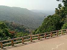
Devimane Ghat
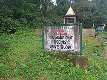
Devimane is a Hill station and High altitude village in Kumta Sirsi taluk of Uttara Kannada District in Karnataka.It is a Hill Station located In Western Ghats.The road to reach this Hill Station is named as Devimane Ghat. Devimane Ghat Road lies in the Western Ghat part of Karnataka, India, ultimately connecting Malenadu town Sirsi and Karavali town Kumta.[2] Being under the lush forest zone in Uttara Kannada District it consists of 10 hairpin curves currently with a well-engineered road that reduces the risk of accidents. The road's elevation ranges from 25 to 567 metres (80 to 1,860 ft). A temple of Goddess Durga Devi is at the beginning of this road at elevation 429m, The ghat section was named after the temple "Devimane", meaning "the home of goddess Devi". There are 5 hairpins curves between Devimane Temple and Sampakhanda. So, Totally there are 15 Hairpin Turns in this stretch of road.
| Devimane Ghat | |
|---|---|
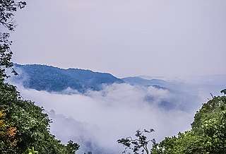 Devimane Ghat view point covered by fog | |
| Elevation | 567 metres (1,860 ft)[1] |
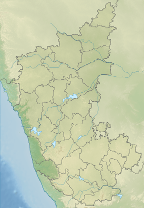
| Location | Karnataka, India |
| Range | Sahyadri Western Ghats |
| Coordinates | 14°31′10″N 74°34′26″E |
 | |
After entering the Western Ghats, there are many sharp curves until Ekkambi. On the Deccan Plateau, three hairpin curves exist between Ekkambi and Sirsi.[3] There are totally 12 bridges constructed in this ghat section. At this point, the road becomes signed SH69/SH142 and is maintained by the Karnataka State Highway works department. The ghat section has been posing a threat to the wildlife present in the slopes of Western Ghat mountain range. Wild animals, including elephants, were hit by vehicles at certain times of the day.[4][5]
Climate
During the months of May, June, July, August, September this region receives heavy rainfall over 6000mm. Villages near Devimane ghat are Hebre, Bandla, Devimane, Hebbail, Kodambale, Sampakhanda receives over 5000mm of rainfall each year creating numerous rivers and waterfalls.
Due to the proximity of ocean the low elevated regions experience high-temperature rise over 40°C during summer. But, in higher elevated regions the temperature would not go beyond 32°C due to the presence of dense forest range caused by heavy rainfall.
Winter season commences from November and ends in February, as it lies in the high elevated region and close to the ocean it experiences Tropical Highland climate and it experiences shivery climate where the temperature drops below 10°C and Sampakhanda being the coldest place where the temperature has dropped below 5°C many times and even in summer season temperature often drops below 12°C. Since the weather statistics have poor track in this region, perfection in the weather numbers has certain deviations. Even in lowland region near Devimane Ghat experiences cold during winter but temperature unusually drops below 15°C.[6] [7]
| Climate data for Devimane | |||||||||||||
|---|---|---|---|---|---|---|---|---|---|---|---|---|---|
| Month | Jan | Feb | Mar | Apr | May | Jun | Jul | Aug | Sep | Oct | Nov | Dec | Year |
| Average high °C (°F) | 29 (84) |
30 (86) |
30 (86) |
31 (88) |
31 (88) |
28 (82) |
26 (79) |
26 (79) |
27 (81) |
30 (86) |
31 (88) |
30 (86) |
29 (84) |
| Average low °C (°F) | 17 (63) |
18 (64) |
20 (68) |
21 (70) |
21 (70) |
21 (70) |
21 (70) |
21 (70) |
21 (70) |
20 (68) |
20 (68) |
19 (66) |
20 (68) |
See also
References
- Google Earth
- "Great Canara Trails behind more red tape". Deccan Herald. Deccan Herald. 2017-12-10. Retrieved 2019-02-02.
- CDM Smith (December 2015). "Widening & Strengthening (to Two Lane With Paved Shoulder) of Kumta to Yekkumbi Section of SH-69 from km 5+300 to km 78+700 in the State of Karnataka" (PDF).
- "Roads, railway tracks turn deathtraps for animals". Deccan Herald. Deccan Herald. 2018-11-10. Retrieved 2019-02-02.
- Kaggere, Niranjan KaggereNiranjan; Jan 12, Bangalore Mirror Bureau; 2017; Ist, 04:00. "A trail that's going nowhere". Bangalore Mirror. Karnataka: Bangalore Mirror. Retrieved 2019-02-02.CS1 maint: numeric names: authors list (link)
- https://timesofindia.indiatimes.com/Samphakanda-hobli-in-Sirsi-taluk-of-Uttara-Kannada-district-recorded-lowest-minimum-temperature-of-11-9C-on-March-7-at-6-15am-/articleshow/31598662.cms
- http://ksndmc.org/Weather_info.aspx
- https://en.climate-data.org/asia/india/karnataka/devimane-1059433/?amp=true