Schleithal
Schleithal is a commune in the Bas-Rhin department in Grand Est in north-eastern France. Located in the northern Lower Rhine just steps from the French-German border. This boundary is defined by the Lauter which gives its name to the small town of Lauterbourg located at the mouth of the river Rhine.
Schleithal | |
|---|---|
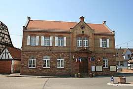 The town hall in Schleithal | |
.svg.png) Coat of arms | |
Location of Schleithal 
| |
 Schleithal  Schleithal | |
| Coordinates: 48°59′22″N 8°02′39″E | |
| Country | France |
| Region | Grand Est |
| Department | Bas-Rhin |
| Arrondissement | Haguenau-Wissembourg |
| Canton | Wissembourg |
| Government | |
| • Mayor (2008–2014) | Joseph Schneider |
| Area 1 | 9.12 km2 (3.52 sq mi) |
| Population (2017-01-01)[1] | 1,428 |
| • Density | 160/km2 (410/sq mi) |
| Time zone | UTC+01:00 (CET) |
| • Summer (DST) | UTC+02:00 (CEST) |
| INSEE/Postal code | 67451 /67160 |
| Elevation | 135–187 m (443–614 ft) |
| 1 French Land Register data, which excludes lakes, ponds, glaciers > 1 km2 (0.386 sq mi or 247 acres) and river estuaries. | |
History
The first writings of Schleithal date from 1145, but some believe that the village dates from 631 (year of establishment of the abbey of Wissembourg). The village became French after the Treaty or otherwise known as Peace of Westphalia in 1648.
See also
References
- "Populations légales 2017". INSEE. Retrieved 6 January 2020.
| Wikimedia Commons has media related to Schleithal. |
| Authority control |
|
|---|
This article is issued from Wikipedia. The text is licensed under Creative Commons - Attribution - Sharealike. Additional terms may apply for the media files.