Frohmuhl
Frohmuhl (German: Frohmühl) is a commune in the Bas-Rhin department in Grand Est in north-eastern France.
Frohmuhl Frohmíl | |
|---|---|
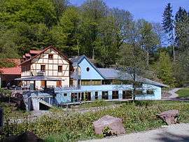 The House of the Water and the River in Frohmuhl | |
.svg.png) Coat of arms | |
Location of Frohmuhl 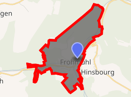
| |
 Frohmuhl  Frohmuhl | |
| Coordinates: 48°54′36″N 7°16′57″E | |
| Country | France |
| Region | Grand Est |
| Department | Bas-Rhin |
| Arrondissement | Saverne |
| Canton | Ingwiller |
| Government | |
| • Mayor (2001–2008) | Gaston Dann |
| Area 1 | 1.64 km2 (0.63 sq mi) |
| Population (2017-01-01)[1] | 181 |
| • Density | 110/km2 (290/sq mi) |
| Time zone | UTC+01:00 (CET) |
| • Summer (DST) | UTC+02:00 (CEST) |
| INSEE/Postal code | 67148 /67290 |
| Elevation | 247–359 m (810–1,178 ft) |
| 1 French Land Register data, which excludes lakes, ponds, glaciers > 1 km2 (0.386 sq mi or 247 acres) and river estuaries. | |
The commune lies within the North Vosges regional natural park.
Geography
A typical valley village set in the pink Plateau Lorraine sandstone, Frohmuhl, like many villages in north-western Alsace, is cut in two by the railway line connecting Strasbourg and Sarreguemines and by the River Eichel. Road access is provided by the departmental road D919.
Agriculture was abandoned here during the second half of the twentieth and the surrounding hills are newly afforested. However, Highland Cattle are currently reared in residual open areas at the bottom of the valley.
Adjacent communes are Puberg and Hinsbourg to the east, Struth and Tieffenbach to the south-west and Weislingen to the north-west.
See also
References
- "Populations légales 2017". INSEE. Retrieved 6 January 2020.
| Wikimedia Commons has media related to Frohmuhl (Bas-Rhin). |
| Authority control |
|
|---|