Itterswiller
Itterswiller (German: Ittersweiler) is a commune in the Bas-Rhin department in Alsace in north-eastern France.
Itterswiller Itterschwiller | |
|---|---|
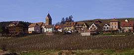 A general view of Itterswiller | |
 Coat of arms | |
Location of Itterswiller 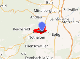
| |
 Itterswiller  Itterswiller | |
| Coordinates: 48°21′53″N 7°25′54″E | |
| Country | France |
| Region | Grand Est |
| Department | Bas-Rhin |
| Arrondissement | Sélestat-Erstein |
| Canton | Obernai |
| Intercommunality | Bernstein et Ungersberg |
| Government | |
| • Mayor (2008–2014) | Vincent Kieffer |
| Area 1 | 11.8 km2 (4.6 sq mi) |
| Population (2017-01-01)[1] | 242 |
| • Density | 21/km2 (53/sq mi) |
| Time zone | UTC+01:00 (CET) |
| • Summer (DST) | UTC+02:00 (CEST) |
| INSEE/Postal code | 67227 /67140 |
| Elevation | 220–287 m (722–942 ft) |
| 1 French Land Register data, which excludes lakes, ponds, glaciers > 1 km2 (0.386 sq mi or 247 acres) and river estuaries. | |
Geography
The village is located on the eastern beginnings of the Vosges Mountains, between Molsheim to the north and Sélestat top the south. It is a few kilometres to the west of the Autoroute A35, the principal north-south highway in Alsace.
Economy
Tourism is important to the local economy which is positioned on the Elsässer Weinstraße. The village also takes a pride in its vineyards.
History
The village is on the course of a Roman road: it is therefore believed that the area must have been settled during the Roman empire period. The name is thought to come from the Latin "Itineris villa" which indicates a hostelry for travellers.
In terms of surviving written records, a so-called Letter of Indulgence to Itterswiller dates from 1330.
Celebrations
An annual church festival takes place at the end of September or start of October.
See also
References
- "Populations légales 2017". INSEE. Retrieved 6 January 2020.
| Wikimedia Commons has media related to Itterswiller. |
| Authority control |
|
|---|