Reipertswiller
Reipertswiller (German: Reipertsweiler) is a commune in the Bas-Rhin department in Grand Est in north-eastern France.
Reipertswiller | |
|---|---|
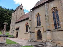 The church in Reipertswiller | |
 Coat of arms | |
Location of Reipertswiller 
| |
 Reipertswiller  Reipertswiller | |
| Coordinates: 48°55′58″N 7°27′56″E | |
| Country | France |
| Region | Grand Est |
| Department | Bas-Rhin |
| Arrondissement | Saverne |
| Canton | Ingwiller |
| Government | |
| • Mayor (2001–2008) | Eric Riffel |
| Area 1 | 19.21 km2 (7.42 sq mi) |
| Population (2017-01-01)[1] | 858 |
| • Density | 45/km2 (120/sq mi) |
| Time zone | UTC+01:00 (CET) |
| • Summer (DST) | UTC+02:00 (CEST) |
| INSEE/Postal code | 67392 /67340 |
| Elevation | 207–421 m (679–1,381 ft) |
| 1 French Land Register data, which excludes lakes, ponds, glaciers > 1 km2 (0.386 sq mi or 247 acres) and river estuaries. | |
In 1999 Reipertswiller had 961 inhabitants. It is bordered on the North by Mouterhouse, on the Northeast by Baerenthal, on the Southeast by Lichtenberg, on the Southwest by Wimmenau and in the Northwest by Goetzenbruck.
The commune is part of the Parc naturel régional des Vosges du Nord
See also
References
- "Populations légales 2017". INSEE. Retrieved 6 January 2020.
| Wikimedia Commons has media related to Reipertswiller. |
| Authority control |
|
|---|
This article is issued from Wikipedia. The text is licensed under Creative Commons - Attribution - Sharealike. Additional terms may apply for the media files.