Santa Ana Pueblo, New Mexico
Santa Ana Pueblo (Eastern Keres: Tamaya [tʰɑmɑjːɑ]) is a census-designated place (CDP) in Sandoval County, New Mexico, United States. As of the 2000 census, the CDP had a total population of 479. It is part of the Albuquerque Metropolitan Statistical Area. The Pueblo, named Tamaya in Keres, administers a total reservation land of 73,000 acres (295 km2) in the Rio Grande valley and is composed of Native Americans who speak an eastern dialect of the Keresan languages.
Santa Ana Pueblo, New Mexico | |
|---|---|
 Pueblo of Santa Ana | |
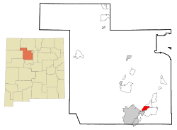 Location of Santa Ana Pueblo, New Mexico | |
 Santa Ana Pueblo, New Mexico Location in the United States | |
| Coordinates: 35°20′44″N 106°31′24″W | |
| Country | United States |
| State | New Mexico |
| County | Sandoval |
| Area | |
| • Total | 7.4 sq mi (19.3 km2) |
| • Land | 6.9 sq mi (17.9 km2) |
| • Water | 0.5 sq mi (1.4 km2) |
| Elevation | 5,249 ft (1,600 m) |
| Population (2000) | |
| • Total | 479 |
| • Density | 69.2/sq mi (26.7/km2) |
| Time zone | UTC-7 (Mountain (MST)) |
| • Summer (DST) | UTC-6 (MDT) |
| ZIP code | 87004 |
| Area code(s) | 505 |
| FIPS code | 35-70250 |
| GNIS feature ID | 0928811 |
The pueblo celebrates an annual feast day for its patron saint, St. Anne, on July 26.
Today, the Pueblo operates the Santa Ana Star Casino and is the site of the Hyatt Regency Tamaya Resort & Spa. The Pueblo owns and operates two championship golf courses, Santa Ana Golf Club and Twin Warriors Golf Club. (http://mynewmexicogolf.com They also run arts & crafts, gardening and cooking enterprises.
Geography
Santa Ana Pueblo is located at 35°20'44" North, 106°31'24" West (35.345446, -106.523309).[1]
According to the United States Census Bureau, the CDP has a total area of 7.4 square miles (19.3 km2), of which, 6.9 square miles (17.9 km2) of it is land and 0.5 square miles (1.4 km2) of it (7.11%) is water.
Demographics
At the 2000 census there were 479 people, 121 households, and 99 families in the CDP. The population density was 69.2 people per square mile (26.7/km2). There were 132 housing units at an average density of 19.1 per square mile (7.4/km2). The racial makeup of the CDP was 1.25% White, 97.29% Native American, 0.84% from other races, and 0.63% from two or more races. 2.51% of the population were Hispanic or Latino of any race.[2] Of the 121 households 43.0% had children under the age of 18 living with them, 41.3% were married couples living together, 31.4% had a female householder with no husband present, and 17.4% were non-families. 14.9% of households were one person and 5.0% were one person aged 65 or older. The average household size was 3.96 and the average family size was 4.42.
The age distribution was 34.9% under the age of 18, 11.5% from 18 to 24, 26.7% from 25 to 44, 17.7% from 45 to 64, and 9.2% 65 or older. The median age was 28 years. For every 100 females, there were 88.6 males. For every 100 females age 18 and over, there were 73.3 males.
The median household income was $45,179 and the median family income was $45,714. Males had a median income of $22,188 versus $23,125 for females. The per capita income for the CDP was $9,857. 5.1% of the population and 4.1% of families were below the poverty line, including 4.1% of those under the age of 18 and 5.3% of those 65 and older.
References
- "US Gazetteer files: 2010, 2000, and 1990". United States Census Bureau. 2011-02-12. Retrieved 2011-04-23.
- "U.S. Census website". United States Census Bureau. Retrieved 2008-01-31.
External links
| Reservations | |
|---|---|
| Pueblos | |
 |
| |
Municipalities and communities of Sandoval County, New Mexico, United States | ||
|---|---|---|
| City | 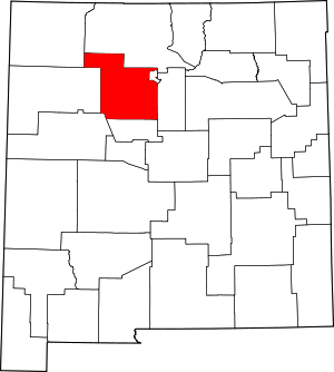 Map of New Mexico highlighting Sandoval County | |
| Towns | ||
| Villages | ||
| CDPs | ||
| Unincorporated community | ||
| Indian reservations |
| |
| Footnotes | ‡This populated place also has portions in an adjacent county or counties | |
| Authority control |
|
|---|