San Narciso, Zambales
San Narciso, officially the Municipality of San Narciso, is a 4th class municipality in the province of Zambales, Philippines. According to the 2015 census, it has a population of 28,360 people.[3]
San Narciso | |
|---|---|
| Municipality of San Narciso | |
 View of San Sebastian Church and plaza from San Narciso Municipal Hall | |
 Seal | |
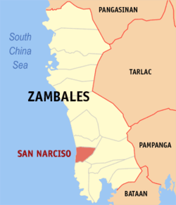 Map of Zambales with San Narciso highlighted | |
| |
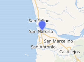
.svg.png) San Narciso Location within the Philippines | |
| Coordinates: 15°01′N 120°05′E | |
| Country | |
| Region | Central Luzon (Region III) |
| Province | Zambales |
| District | 2nd district |
| Barangays | 17 (see Barangays) |
| Government | |
| • Type | Sangguniang Bayan |
| • Mayor | William T. Lim |
| • Vice Mayor | Joel E. Manangan |
| • Congressman | Cheryl D. Montalla |
| • Electorate | 19,587 voters (2019) |
| Area | |
| • Total | 71.60 km2 (27.64 sq mi) |
| Elevation | 15.6 m (51.2 ft) |
| Population (2015 census)[3] | |
| • Total | 28,360 |
| • Density | 400/km2 (1,000/sq mi) |
| • Households | 7,038 |
| Economy | |
| • Income class | 4th municipal income class |
| • Poverty incidence | 13.47% (2015)[4] |
| • Revenue (₱) | 78,631,700.31 (2016) |
| Time zone | UTC+8 (PST) |
| ZIP code | 2205 |
| PSGC | |
| IDD : area code | +63 (0)47 |
| Climate type | tropical monsoon climate |
| Native languages | Ilocano Tagalog Sambal |
San Narciso is famous for its beaches along the South China Sea that are suited for surfing. Many local celebrities have already visited San Narciso to surf in its beaches which is 163 kilometres (101 mi) from Manila.
The Philippine Merchant Marine Academy or PMMA is located here. San Narciso also houses the Magsaysay Memorial College, which offers bachelors courses and other 2-year courses. Also located in San Narciso is the Zambales Academy, one of the oldest secondary education institution in the province, it is where former president Ramon Magsaysay took his secondary education.
Geography
Average Elevation: 3.6 metres (12 ft) above sea level
Highest Elevation: 800 metres (2,600 ft) above sea level
Climate
| Climate data for San Narciso, Zambales | |||||||||||||
|---|---|---|---|---|---|---|---|---|---|---|---|---|---|
| Month | Jan | Feb | Mar | Apr | May | Jun | Jul | Aug | Sep | Oct | Nov | Dec | Year |
| Average high °C (°F) | 31 (88) |
32 (90) |
33 (91) |
34 (93) |
32 (90) |
31 (88) |
29 (84) |
29 (84) |
29 (84) |
30 (86) |
31 (88) |
31 (88) |
31 (88) |
| Average low °C (°F) | 20 (68) |
20 (68) |
21 (70) |
23 (73) |
25 (77) |
25 (77) |
25 (77) |
25 (77) |
24 (75) |
23 (73) |
22 (72) |
20 (68) |
23 (73) |
| Average precipitation mm (inches) | 16 (0.6) |
18 (0.7) |
28 (1.1) |
51 (2.0) |
200 (7.9) |
253 (10.0) |
301 (11.9) |
293 (11.5) |
246 (9.7) |
171 (6.7) |
70 (2.8) |
28 (1.1) |
1,675 (66) |
| Average rainy days | 6.2 | 7.1 | 10.4 | 15.5 | 24.4 | 26.4 | 28.2 | 27.5 | 26.2 | 23.6 | 15.9 | 8.7 | 220.1 |
| Source: Meteoblue [5] | |||||||||||||
Barangays
San Narciso is subdivided into 17 barangays. [2]
- Alusiis
- Beddeng
- Candelaria
- Dallipawen
- Grullo
- La Paz
- Libertad
- Namatacan
- Natividad
- Omaya
- Paite
- Patrocinio
- San Jose
- San Juan
- San Pascual
- San Rafael
- Simminublan
History
The Municipality of San Narciso was founded in the early part of 18th century. The migrants from the Ilocandia arrived in the area and established their settlement in Alusiis, which was the first name of the pueblo which later became San Narciso.
San Narcsio became the official name of the town by a Royal Decree issued by the Spanish Governor General Narciso Claveria and Archbishop Jose Soque on February 12, 1846.
The people of San Narciso participated in the Philippine Revolution against Spain. When the Katipunan was organized by Andres Bonifacio and sent his representatives in San Narciso, many prominent men of the town became members. Pantaleon Dumlao became the head of the local organization.
Demographics
| Population census of San Narciso | ||
|---|---|---|
| Year | Pop. | ±% p.a. |
| 1903 | 7,528 | — |
| 1918 | 8,779 | +1.03% |
| 1939 | 9,723 | +0.49% |
| 1948 | 14,085 | +4.20% |
| 1960 | 14,993 | +0.52% |
| 1970 | 17,622 | +1.63% |
| 1975 | 19,278 | +1.82% |
| 1980 | 19,119 | −0.17% |
| 1990 | 22,891 | +1.82% |
| 1995 | 21,651 | −1.04% |
| 2000 | 23,522 | +1.79% |
| 2007 | 24,856 | +0.76% |
| 2010 | 26,966 | +3.01% |
| 2015 | 28,360 | +0.96% |
| Source: Philippine Statistics Authority[3][6][7][8] | ||
In the 2015 census, the population of San Narciso, Zambales, was 28,360 people,[3] with a density of 400 inhabitants per square kilometre or 1,000 inhabitants per square mile.
Economy
Livelihood:
- Auto/Diesel Repair
- Banks
- Beach Resorts
- Beauty Parlors/Barbers
- Cattle Raising
- Computer Rentals and Repairs
- Convenience stores
- Duck Raising
- Ecotourism
- Farming
- Fishing
- Garment Industry
- Goat Raising
- Hardware
- Hollow Blocks Making
- Laundry
- Maritime education
- Metal Craft
- Money transfers
- Pot Clay Making
- Restaurants (Fast food, casual dining, catering...)
- Sash & Iron Works
- Schools (Primary, Secondary, College)
- Swimming pools
- Tarpaulin printing
- Trading/Vending
- Tricycle Body Making (Sidecar)
- Tricycle transport
- Videoke bars
- Water Refilling
Principal crops:
- Rice
- String Beans
- Onions (Local name: Lasona/sibuyas)
- Eggplants, Tomatoes
Customs and traditions
The first settlers of San Narciso who came from Paoay, Ilocos Norte, and Agno, Pangasinan, then a part of Zambales brought forth with them customs which became traditions. Celebrating the anniversaries of their dead, birthday and baptismal parties are most common among them. This customs have been practiced up to the present time. The family honoring the dead usually prepares a luncheon or merienda to be offered to the invited guests who are relatives of the hosts.
List of former municipal executives

Spanish regime:
- 1884 Tomas Bernabe Gobernadorcillo
- 1886 Mariano Apolinario Gobernadorcillo
- 1887 Paulo Fogata Gobernadorcillo
- 1888 Esteban Foton Gobernadorcillo
- 1889 Mariano Marañon Gobernadorcillo
- 1890 Francisco Fajarito Gobernadorcillo
- 1891 Gregorio Farañal Gobernadorcillo
- 1892 Leocadio Firme Gobernadorcillo
- 1893 Juan Flordeliza Dumlao Gobernadorcillo
- 1894 Quirico Amon Sr. Gobernadorcillo
- 1895 Luis Fogata Gobernadorcillo
- 1895 Cipriano Fogata Gobernadorcillo
Revolutionary government:
- 1897 Cipriano Fernandez Capitan Municipal
- 1898 Casamiro Amon Capitan Municipal 1
- 1900 Vicente Posadas Capitan Municipal
American regime:
- 1903–1904 Simeon Marañon Presidente Municipal
- 1905–1906 Angel Dumlao Presidente Municipal
- June 1906-Jan. 8, 1908 Simeon Villanueva Presidente Municipal
- June 9, 1908-Dec. 1909 Angle Dumlao Presidente Municipal
- 1910–1912 Victor Amos Presidente Municipal
- 1912–1916 Mariano Villanueva Presidente Municipal
- 1916–1919 Marcos Fuerte Presidente Municipal
- 1919–1922 Severino Fuertes Presidente Municipal
- 1922–1925 Paulino Delos Santos Presidente Municipal
- 1926–1931 Esteban Florita Presidente Municipal
- 1932–1934 Donato Amon Presidente Municipal
Commonwealth:
- 1934–1940 Ireneo Delos Reyes Municipal Mayor
- 1941-Oct. 1942 Pacifico Fuerte Municipal Mayor
Japanese Occupation:
- Oct. 1942–1944 Sebastian Fogata Municipal Mayor
Liberation Military Government:
- February 1945 Gerardo Evangelista Municipal Mayor
- May 1945 – July 1946 Pacifico Fuerte Municipal Mayor
- 1947–1948 Severino Fuertes Municipal Mayor
Republic of the Philippines:
- Aug. 1948–1955 Sebastian Fogata Municipal Mayor
- Jan. 1956–1960 Jose Delos Santos Municipal Mayor
- Jan. 1960–1963 Sebastian Fogata Municipal Mayor
- Jan. 1963–1986 Francisco A. Galvez, Jr. Municipal Mayor
- 1986–1989 Quirico F. Abrajano, Jr. Municipal Mayor
- 1989–1992 Franciso A. Galvez, Jr. Municipal Mayor
- 1992–2001 Quirico F. Abrajano, Jr. Municipal Mayor
- 2001 – 2010 William T. Lim Municipal Mayor
- 2010 - 2016 Peter T. Lim Municipal Mayor
- 2016 to present La Rainne Abad-Sarmiento Municipal Mayor
References
- "Municipality". Quezon City, Philippines: Department of the Interior and Local Government. Retrieved May 31, 2013.
- "Province: Zambales". PSGC Interactive. Quezon City, Philippines: Philippine Statistics Authority. Retrieved November 12, 2016.
- Census of Population (2015). "Region III (Central Luzon)". Total Population by Province, City, Municipality and Barangay. PSA. Retrieved June 20, 2016.
- "PSA releases the 2015 Municipal and City Level Poverty Estimates". Quezon City, Philippines. Retrieved January 1, 2020.
- "San Narciso: Average Temperatures and Rainfall". Meteoblue. Retrieved April 26, 2020.
- Census of Population and Housing (2010). "Region III (Central Luzon)". Total Population by Province, City, Municipality and Barangay. NSO. Retrieved June 29, 2016.
- Censuses of Population (1903–2007). "Region III (Central Luzon)". Table 1. Population Enumerated in Various Censuses by Province/Highly Urbanized City: 1903 to 2007. NSO.
- "Province of Zambales". Municipality Population Data. Local Water Utilities Administration Research Division. Retrieved December 17, 2016.
External links
| Wikimedia Commons has media related to San Narciso, Zambales. |
Places adjacent to San Narciso, Zambales | ||||||||||
|---|---|---|---|---|---|---|---|---|---|---|
| ||||||||||
Iba (capital) | |
| Municipalities | |
| Highly urbanized city |
|
| Barangays | |