San Felipe, Zambales
San Felipe, officially the Municipality of San Felipe, is a 4th class municipality in the province of Zambales, Philippines. According to the 2015 census, it has a population of 23,183 people.[3]
San Felipe | |
|---|---|
| Municipality of San Felipe | |
 Welcome Arch | |
 Seal | |
| Motto(s): Care for San Felipe... Unite for San Felipe... Be Loyal to San Felipe... | |
 Map of Zambales with San Felipe highlighted | |

| |
.svg.png) San Felipe Location within the Philippines | |
| Coordinates: 15°03′43″N 120°04′12″E | |
| Country | |
| Region | Central Luzon (Region III) |
| Province | Zambales |
| District | 2nd district |
| Founded | 1795 |
| Barangays | 11 (see Barangays) |
| Government | |
| • Type | Sangguniang Bayan |
| • Mayor | Leo John M. Farrales |
| • Vice Mayor | Mary Ann R. Quiba |
| • Congressman | Cheryl D. Montalla |
| • Electorate | 15,177 voters (2019) |
| Area | |
| • Total | 111.60 km2 (43.09 sq mi) |
| Elevation | 12.9 m (42.3 ft) |
| Population (2015 census)[3] | |
| • Total | 23,183 |
| • Density | 210/km2 (540/sq mi) |
| • Households | 5,585 |
| Economy | |
| • Income class | 4th municipal income class |
| • Poverty incidence | 16.66% (2015)[4] |
| • Revenue (₱) | 80,274,773.22 (2016) |
| Time zone | UTC+8 (PST) |
| ZIP code | 2204 |
| PSGC | |
| IDD : area code | +63 (0)47 |
| Climate type | tropical monsoon climate |
| Native languages | Ilocano Tagalog Sambal |
Much of the population are Ilocanos, descendants of migrants from Ilocos.
The town was affected by the 1991 Mount Pinatubo eruption, being buried in about a meter in volcanic ash but damage was comparatively light.[5]
History
San Felipe was one among the little villages along the coastal region of Zambales during the pre-Spanish period. The first inhabitants were the Malay Zambas who lived in lowland which they themselves called Hindol. There were also Negritoes but most of them lived in mountains.
A few years after the discovery of the Philippines, all places in the country had been explored by the Spanish authorities and the exploration of Zambales began in 1572 by Juan de Salcedo, grandson of Miguel Lopez de Legaspi, first Spanish Governor General of the Philippines. Juan de Salcedo and Spanish followers made a survey of its coastal region and organize communities which were first called encomiendas but which were later called pueblos. As the population of the villages increased which was caused by the steady immigration of Ilocanos from the Ilocandia region before 1800 until 1860, more pueblos were organized.
The first waves of Ilocanos found their way to Hindol, which was later called Sindol, and less than the kilometers south of Sindol was the place called Bobulon. Hindol was a Zambal Aeta name of a tree than abundant in the place. Bobulon was also a kind tree then abundant at the Public Plaza. However, there was another version why it was called Bobulon. It was said that the first voyage of Ilocano settlers had all the favorable wind ( bulon ) from Paoay, Ilocos Norte to this village. The other waves of Ilocano settlers, who were mostly merchants and fishermen, came from Vigan and San Vicente, Ilocos Sur.
The first seat of the pueblo government was in Sindol and the head of the pueblo was called Capitan Municipal who as head of the pueblo was responsible in paying the taxes which could not be collected from his barangays which were headed by Cabezas de barangay. As gathered from reliable sources, one of the town executives when the seat of the government was still here in Sindol was Capitan Municipal Pedro Farañal, father of the late Municipal President Juan Farañal. The pueblo was later transferred from Sindol to Bobulon because the latter was already more populated, had a wider area for residential purposes, and it was farther from the mountains were the aetas, still wild lived. The name Bobulon was changed to San Felipe when it was founded in 1853. As to how the town of San Felipe got its present name, the most reliable fact learned so far was that four “saintly” brothers from Ilocandia, namely Marcelino, Antonio, Narciso and Felipe settled in the about to be organized pueblos which were later named San Marcelino, San Antonio, San Narciso and San Felipe. As a matter of fact, most of the inhabitants of these four towns were Ilocanos from the Ilocos region. Under the Spanish regime and during the early part of American regime, San Felipe was a separate town. Its first Municipal President was Don Saturnino Pastor who was the town executive from January 1, 1901 to December 31, 1902. For the purpose of governmental administration, San Felipe was incorporated with San Narciso, The Municipal President of the combined towns of San Felipe and San Narciso was Don Simeon Maranon and Nicolas Amagna was the Municipal Vice-President. Being a smaller town, San Felipe was only entitled to four Councilors while San Narciso had five. The councilors for San Felipe were – Don Juan Farañal, Don Victorino Amancio, Don Alejo Apostol and Don Macario Manglicmot. These officials, together with some others in San Felipe, later worked for the separation of San Felipe from San Narciso through Don Alberto Barretto, who was then a member of the first Philippine Assembly. Meanwhile, before the separation Don Angel Dumlao y Farrales, from San Narciso, took over as Municipal President for San Felipe – San Narciso covering the period from January 1, 1905 to February 28, 1908.
Under the combined leadership of Nicolas Amagna, Flaviano Dumlao, Severo Amagna, Nemesio Farrales, Isidoro Fuenticilla and Joaquin Feria a resolution was adopted to effect the final separation of San Felipe from San Narciso. On March 1, 1908, San Felipe was formally separated from San Narciso and the first Municipal officials after separation were;
- Nicolas Amagna - Municipal President
- Isidoro Fuenticilla - Mun. Vice-President
- Santiago Labrador - Councilor
- Flaviano Dumlao - Councilor
- Jose Abille - Councilor
- Leoncio Borja - Councilor
- Bartolome Mendaros - Councilor
- Nemesio Farrales - Councilor
- Joaquin Feria - Councilor
- Macario Rico - Councilor
Barangays (district) in the poblacion and barangays (barrios) outside the town proper.
Barangays in the poblacion and their names :
Barangay Apostol has been named in honor of the late Capitan Municipal Juan Apostol, Barangay Manglicmot has been named in honor of the late Capitanes Municipal – Julian Manglicmot, Casimiro Manglicmot and Lope Manglicmot. Barangay Feria has been named in honor of the late Capitan Municipal Ambrosio Feria, Barangay Amagna has been named in honor of Municipal President Nicolas Amagna. Barangay Rosete has been named in honor of the late Capitan Municipal Pedro Rosete. Barangay Farañal has been named in honor of the late Capitan Municipal Pedro Farañal when the seat of the government was still in Sindol.
Barangays outside the poblacion and their names :
Barangay Balincaguing's name was derived from the Zambal word balin which means house or home and caguing which means wild bats.
Barangays
San Felipe is subdivided into 11 barangays. [2]
Barangay Population (2010)[6] Barangay Chairman Amagna (Urban) 1,298 Gregorio A. Reguindin Apostol (Urban) 1,792 Rogelio G. Rico Balincaguing 978 Cynthia A. Abdon Farañal (Urban) 1,820 Rolando F. De Jesus Feria (Urban) 978 Efren N. Delos Reyes Maloma 4,608 Fernando R. Aranas Manglicmot (Urban) 1,636 Glenn F. Penarubia Rosete (Urban) 1,463 Noel S. Malala San Rafael 1,077 Marlita B. Santos Sindol 2,130 Rodelio Dasig Santo Niño 4,246 Sir Alfred D. Abille
Climate
| Climate data for San Felipe, Zambales | |||||||||||||
|---|---|---|---|---|---|---|---|---|---|---|---|---|---|
| Month | Jan | Feb | Mar | Apr | May | Jun | Jul | Aug | Sep | Oct | Nov | Dec | Year |
| Average high °C (°F) | 31 (88) |
32 (90) |
33 (91) |
34 (93) |
32 (90) |
31 (88) |
29 (84) |
29 (84) |
29 (84) |
30 (86) |
31 (88) |
31 (88) |
31 (88) |
| Average low °C (°F) | 20 (68) |
20 (68) |
21 (70) |
23 (73) |
25 (77) |
25 (77) |
25 (77) |
25 (77) |
24 (75) |
23 (73) |
22 (72) |
20 (68) |
23 (73) |
| Average precipitation mm (inches) | 16 (0.6) |
18 (0.7) |
28 (1.1) |
51 (2.0) |
200 (7.9) |
253 (10.0) |
301 (11.9) |
293 (11.5) |
246 (9.7) |
171 (6.7) |
70 (2.8) |
28 (1.1) |
1,675 (66) |
| Average rainy days | 6.2 | 7.1 | 10.4 | 15.5 | 24.4 | 26.4 | 28.2 | 27.5 | 26.2 | 23.6 | 15.9 | 8.7 | 220.1 |
| Source: Meteoblue [7] | |||||||||||||
Demographics
| Population census of San Felipe | ||
|---|---|---|
| Year | Pop. | ±% p.a. |
| 1903 | 4,326 | — |
| 1918 | 5,151 | +1.17% |
| 1939 | 6,551 | +1.15% |
| 1948 | 7,781 | +1.93% |
| 1960 | 9,861 | +1.99% |
| 1970 | 13,283 | +3.02% |
| 1975 | 13,905 | +0.92% |
| 1980 | 13,834 | −0.10% |
| 1990 | 15,624 | +1.22% |
| 1995 | 16,837 | +1.41% |
| 2000 | 17,702 | +1.08% |
| 2007 | 21,322 | +2.60% |
| 2010 | 22,020 | +1.18% |
| 2015 | 23,183 | +0.98% |
| Source: Philippine Statistics Authority[3][8][9][10] | ||
In the 2015 census, the population of San Felipe, Zambales, was 23,183 people,[3] with a density of 210 inhabitants per square kilometre or 540 inhabitants per square mile.
Religion
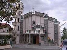
There are local branches of the Christian denominations of Methodist, Philippine Independent Church, International Assemblies of the First Born, Jesus is Lord and Roman Catholic Church.
The Cathedral of San Roque (Saint Roch in English), the episcopal see of the Zambales diocese of the Philippine Independent Church is located next to the plaza.
The local parish of the Catholic Church is also dedicated to San Roque and was staffed by the Columban Fathers until recent years.
Education
There are private, public and parochial elementary, high schools and technological college in San Felipe
Elementary
Public:
- San Felipe Central Elementary School (East)
- San Felipe Central Elementary School (West)
- Santo Nino Elementary School
- Maloma Community Elementary School
- Santo Tomas Elementary School
- Bubolon Elementary School
- Sindol Elementary School
- San Rafael Elementary School
- Balincaguing Elementary School
- Laoag Elementary School
- Sagpat Elementary School
Private:
- Pedro M. Arce Ecumenical School, Inc.
- St. Columban's Montessori School
- Luke 19:4 Child Development Center, Inc
High schools
Public:
- Governor Manuel D. Barretto National High School
- San Rafael Technical Vocational High School
- Sagpat High School
- Don Getulio Feria Arindaeng High School
- Paite- Balincaguing National High School
Private:
- Zambales Central Institute
- St. Columban's Montessori School
Colleges
- Technological College of San Felipe
Landmarks and places of interest
- Century Old Tree: Situated in Barangay Maloma, San Felipe, Zambales.
- Coastal Beach Area: Barangay Santo Nino, San Felipe, Zambales.
- Barrio Liwliwa: Liwliwa is a prime surfing spot three hours away from Manila. Resorts includes Kapitan's Liwa Surf Resort, Kuya Bot's, Board Culture Liw-Liwa (BCL), La Sarina, Aragoza Beach Resort, The Circle Hostel and Camp Rofelio Surfing Beach Resort in San Felipe.
- Lubong-Nangoloan Waterfalls: Situated in Barangay Feria, San Felipe, Zambales.
- Grotto Falls: Situated in Barangay Feria, San Felipe, Zambales.
- Benedictine Retreat House: This retreat house is run by the Benedictine sisters and was constructed on land donated by the Sebastian family. The late Sister Henrietta Sebastian was a nun of the Benedictine order. A number of schools and religious groups, even as far away from Manila, conduct their retreats in this facility. The compound also houses relocated groups that were displaced by Mt. Pinatubo. You can also buy religious articles from them (for pasalubongs).
- Sabangan of the North: A picnic and/or scenic site. From Sindol cars, jeeps, SUVs and tricycles can easily navigate the road which is part concrete and dirt road to take you to there.
- Brandenburg Resort: Located at Barangay Sindol, San Felipe, Zambales.
- Montecruz Beach Resort: Located at Barangay Santo Nino, San Felipe.
- Greenspace Artist Village: Located at Liwliwa, San Felipe, Zambales.
Gallery
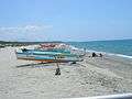 San Felipe Beach
 San Roque Catholic Church
 San Felipe Zambales Public Market and Mall
References
- "Municipality". Quezon City, Philippines: Department of the Interior and Local Government. Retrieved 31 May 2013.
- "Province: Zambales". PSGC Interactive. Quezon City, Philippines: Philippine Statistics Authority. Retrieved 12 November 2016.
- Census of Population (2015). "Region III (Central Luzon)". Total Population by Province, City, Municipality and Barangay. PSA. Retrieved 20 June 2016.
- "PSA releases the 2015 Municipal and City Level Poverty Estimates". Quezon City, Philippines. Retrieved 1 January 2020.
- Robert Gonzaga, Tonette Orejas (June 16, 2011). "Zambales bore brunt of Mt. Pinatubo's fury". INQUIRER.net. Retrieved 26 March 2013.
- "Total Population by Province, City, Municipality and Barangay: as of May 1, 2010" (PDF). 2010 Census of Population and Housing. Philippine Statistics Authority. Archived from the original (PDF) on November 15, 2012. Retrieved February 15, 2013.
- "San Felipe: Average Temperatures and Rainfall". Meteoblue. Retrieved 26 April 2020.
- Census of Population and Housing (2010). "Region III (Central Luzon)". Total Population by Province, City, Municipality and Barangay. NSO. Retrieved 29 June 2016.
- Censuses of Population (1903–2007). "Region III (Central Luzon)". Table 1. Population Enumerated in Various Censuses by Province/Highly Urbanized City: 1903 to 2007. NSO.
- "Province of Zambales". Municipality Population Data. Local Water Utilities Administration Research Division. Retrieved 17 December 2016.
External links
| Wikimedia Commons has media related to San Felipe, Zambales. |
- San Felipe Profile at PhilAtlas.com
- Website
- Coordinates
- Philippine Standard Geographic Code
- Philippine Census Information
Places adjacent to San Felipe, Zambales | ||||||||||
|---|---|---|---|---|---|---|---|---|---|---|
| ||||||||||
Iba (capital) | |
| Municipalities | |
| Highly urbanized city |
|
| Barangays | |