Palauig
Palauig, officially the Municipality of Palauig, is a 3rd class municipality in the province of Zambales, Philippines. According to the 2015 census, it has a population of 34,947 people.[3]
Palauig | |
|---|---|
| Municipality of Palauig | |
 Downtown area | |
 Flag  Seal | |
 Map of Zambales with Palauig highlighted | |

| |
.svg.png) Palauig Location within the Philippines | |
| Coordinates: 15°26′N 120°03′E | |
| Country | |
| Region | Central Luzon (Region III) |
| Province | Zambales |
| District | 2nd district |
| Founded | 1870 |
| Barangays | 19 (see Barangays) |
| Government | |
| • Type | Sangguniang Bayan |
| • Mayor | Billy M. Aceron |
| • Vice Mayor | Arnold A. Anaud |
| • Congressman | Cheryl D. Montalla |
| • Electorate | 25,911 voters (2019) |
| Area | |
| • Total | 310.00 km2 (119.69 sq mi) |
| Elevation | 10.0 m (32.8 ft) |
| Population (2015 census)[3] | |
| • Total | 34,947 |
| • Density | 110/km2 (290/sq mi) |
| • Households | 7,857 |
| Economy | |
| • Income class | 3rd municipal income class |
| • Poverty incidence | 22.91% (2015)[4] |
| • Revenue (₱) | 117,624,050.91 (2016) |
| Time zone | UTC+8 (PST) |
| ZIP code | 2210 |
| PSGC | |
| IDD : area code | +63 (0)47 |
| Climate type | tropical monsoon climate |
| Native languages | Sambal Ilocano Tagalog |
The municipality of Palauig is the nearest mainland to the Philippine-claimed EEZ Panatag Shoal, or Scarborough Shoal.
At present, Palauig is headed by Mayor Billy M. Aceron , with the Municipal Council called Sangguniang Bayan with 8 members, particularly 7 regular Councilors and the Association of Barangay Captains (ABC) President Bel Ponce Altares.
Barangays
Palauig is politically subdivided into 19 barangays. [2]
- Alwa
- Bato
- Bulawen
- Cauyan
- East Poblacion
- Garreta
- Libaba
- Liozon
- Lipay
- Locloc
- Macarang
- Magalawa
- Pangolingan
- Salaza
- San Juan
- Santo Niño
- Santo Tomas
- San Vicente
- West Poblacion
Climate
| Climate data for Palauig, Zambales | |||||||||||||
|---|---|---|---|---|---|---|---|---|---|---|---|---|---|
| Month | Jan | Feb | Mar | Apr | May | Jun | Jul | Aug | Sep | Oct | Nov | Dec | Year |
| Average high °C (°F) | 31 (88) |
32 (90) |
33 (91) |
34 (93) |
32 (90) |
31 (88) |
29 (84) |
29 (84) |
29 (84) |
30 (86) |
31 (88) |
31 (88) |
31 (88) |
| Average low °C (°F) | 20 (68) |
20 (68) |
21 (70) |
23 (73) |
25 (77) |
25 (77) |
25 (77) |
25 (77) |
24 (75) |
23 (73) |
22 (72) |
20 (68) |
23 (73) |
| Average precipitation mm (inches) | 16 (0.6) |
18 (0.7) |
28 (1.1) |
51 (2.0) |
200 (7.9) |
253 (10.0) |
301 (11.9) |
293 (11.5) |
246 (9.7) |
171 (6.7) |
70 (2.8) |
28 (1.1) |
1,675 (66) |
| Average rainy days | 6.2 | 7.1 | 10.4 | 15.5 | 24.4 | 26.4 | 28.2 | 27.5 | 26.2 | 23.6 | 15.9 | 8.7 | 220.1 |
| Source: Meteoblue [5] | |||||||||||||
Demographics
| Population census of Palauig | ||
|---|---|---|
| Year | Pop. | ±% p.a. |
| 1903 | 3,363 | — |
| 1918 | 4,406 | +1.82% |
| 1939 | 6,026 | +1.50% |
| 1948 | 8,386 | +3.74% |
| 1960 | 10,392 | +1.80% |
| 1970 | 14,546 | +3.42% |
| 1975 | 16,359 | +2.38% |
| 1980 | 17,176 | +0.98% |
| 1990 | 21,577 | +2.31% |
| 1995 | 26,794 | +4.14% |
| 2000 | 29,983 | +2.44% |
| 2007 | 30,747 | +0.35% |
| 2010 | 33,286 | +2.93% |
| 2015 | 34,947 | +0.93% |
| Source: Philippine Statistics Authority[3][6][7][8] | ||
In the 2015 census, the population of Palauig was 34,947 people,[3] with a density of 110 inhabitants per square kilometre or 280 inhabitants per square mile.
Language
Most of the citizens in the town proper, known locally as 'Poblacion' speak Sambal followed by Ilocano and Tagalog. At present generation Filipino (Tagalog) the country's national language became the local tongue of the people of Poblacion; although Sambal still the familiar dialect spoken by the older generations in the public. The barangays of Alwa, Bato, Salaza, San Vicente, and Pangolingan were known to be a majority of Ilocano speakers. While Liozon is known to be sambal speaking Barangay. Except for the rest were still sambal is the majority dialect with a minority of Tagalog and Ilocano.
Tourism
Palauig is home to the mountain climbing resort of Mount Tapulao. Because of cold climate on its summit similar to Baguio City, it has become an attraction to many local and foreign mountaineering groups and tourists. The Municipal Tourism Authority of the Palauig Municipal Government also promotes the Magalawa Island Resort and Famous Beach Resorts along the coastal Barangay of Locloc.
Due to the municipal government's aggressive tourism campaign, local and foreign tourist arrivals in the municipality is on the rise and bringing Palauig as another Tourist destination in Zambales Province.
Special Administrative Zone
- Panatag Shoal (Scarborough Shoal)
- Palauig Point (Parola)(Lighthouse)
Gallery
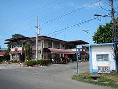 Municipal hall and police station
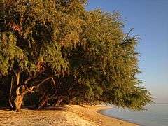 Magalawa Island
 Town center
 Parish of the Immaculate Conception
References
- "Municipality". Quezon City, Philippines: Department of the Interior and Local Government. Retrieved 31 May 2013.
- "Province: Zambales". PSGC Interactive. Quezon City, Philippines: Philippine Statistics Authority. Retrieved 12 November 2016.
- Census of Population (2015). "Region III (Central Luzon)". Total Population by Province, City, Municipality and Barangay. PSA. Retrieved 20 June 2016.
- "PSA releases the 2015 Municipal and City Level Poverty Estimates". Quezon City, Philippines. Retrieved 1 January 2020.
- "Palauig: Average Temperatures and Rainfall". Meteoblue. Retrieved 26 April 2020.
- Census of Population and Housing (2010). "Region III (Central Luzon)". Total Population by Province, City, Municipality and Barangay. NSO. Retrieved 29 June 2016.
- Censuses of Population (1903–2007). "Region III (Central Luzon)". Table 1. Population Enumerated in Various Censuses by Province/Highly Urbanized City: 1903 to 2007. NSO.
- "Province of Zambales". Municipality Population Data. Local Water Utilities Administration Research Division. Retrieved 17 December 2016.
External links
| Wikimedia Commons has media related to Palauig, Zambales. |
Places adjacent to Palauig | ||||||||||
|---|---|---|---|---|---|---|---|---|---|---|
| ||||||||||
Iba (capital) | |
| Municipalities | |
| Highly urbanized city |
|
| Barangays | |