Saint-Jean-de-Losne
Saint-Jean-de-Losne is a commune in the Côte-d'Or department in eastern France. It is about 25 km (16 mi) southeast of Dijon.
Saint-Jean-de-Losne | |
|---|---|
 Bridge over the Saône River | |
 Coat of arms | |
Location of Saint-Jean-de-Losne 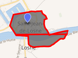
| |
 Saint-Jean-de-Losne  Saint-Jean-de-Losne | |
| Coordinates: 47°06′14″N 5°15′53″E | |
| Country | France |
| Region | Bourgogne-Franche-Comté |
| Department | Côte-d'Or |
| Arrondissement | Beaune |
| Canton | Brazey-en-Plaine |
| Intercommunality | Rives de Saône |
| Government | |
| • Mayor (2008–2014) | Gilles Chatel |
| Area 1 | 0.5 km2 (0.2 sq mi) |
| Population (2017-01-01)[1] | 1,092 |
| • Density | 2,200/km2 (5,700/sq mi) |
| Time zone | UTC+01:00 (CET) |
| • Summer (DST) | UTC+02:00 (CEST) |
| INSEE/Postal code | 21554 /21170 |
| Elevation | 179–182 m (587–597 ft) (avg. 184 m or 604 ft) |
| 1 French Land Register data, which excludes lakes, ponds, glaciers > 1 km2 (0.386 sq mi or 247 acres) and river estuaries. | |
History
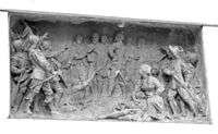
Monument commemorating the 1636 siege, by Mathurin Moreau
Despite its size, the town's position on the Saône River meant it featured in a number of battles. In October 1636, during the Thirty Years War, the fortress was besieged by an Imperial army; the garrison commander, Mothe-Houdancourt, held out long enough to be relieved.[2]
During the closing stages of the Napoleonic Wars in January 1814, the local inhabitants repelled several attempts by the Austrians to seize the bridge. In recognition, Napoleon awarded the town the Legion of Honour, which still appears on the coat of arms.
Population
| Historical population | ||
|---|---|---|
| Year | Pop. | ±% |
| 1962 | 1,528 | — |
| 1968 | 1,623 | +6.2% |
| 1975 | 1,605 | −1.1% |
| 1982 | 1,476 | −8.0% |
| 1990 | 1,342 | −9.1% |
| 1999 | 1,257 | −6.3% |
| 2008 | 1,204 | −4.2% |
Sources
- Jacques, Tony (2007). Dictionary of Battles and Sieges: P-Z. Greenwood. ISBN 978-0313335396.CS1 maint: ref=harv (link)
| Wikimedia Commons has media related to Saint-Jean-de-Losne. |
| Authority control |
|
|---|
This article is issued from Wikipedia. The text is licensed under Creative Commons - Attribution - Sharealike. Additional terms may apply for the media files.