Arrans
Arrans is a commune in the Côte-d'Or department in the Bourgogne-Franche-Comté region of eastern France.
Arrans | |
|---|---|
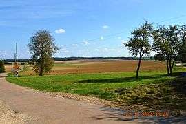 The landscape of Arrans | |
Location of Arrans 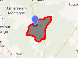
| |
 Arrans  Arrans | |
| Coordinates: 47°41′48″N 4°19′10″E | |
| Country | France |
| Region | Bourgogne-Franche-Comté |
| Department | Côte-d'Or |
| Arrondissement | Montbard |
| Canton | Montbard |
| Intercommunality | CC Montbardois |
| Government | |
| • Mayor (2014-2020) | Yolaine de Courson |
| Area 1 | 10.52 km2 (4.06 sq mi) |
| Population (2017-01-01)[1] | 73 |
| • Density | 6.9/km2 (18/sq mi) |
| Time zone | UTC+01:00 (CET) |
| • Summer (DST) | UTC+02:00 (CEST) |
| INSEE/Postal code | 21025 /21500 |
| Elevation | 249–332 m (817–1,089 ft) (avg. 320 m or 1,050 ft) |
| 1 French Land Register data, which excludes lakes, ponds, glaciers > 1 km2 (0.386 sq mi or 247 acres) and river estuaries. | |
Geography
Arrans is located some 6 km north of Montbard and 5 km south-east of Asnières-en-Montagne. Access to the commune is by the D5 road from Montbard in the south which passes through the heart of the commune and the village and continues north to Verdonnet. The D119 road also links the village to Asnières-en-Montagne in the north-west. The D5E branches off the D5 in the commune and goes south-west to Saint-Rémy. The commune is mostly forest with farmland around and east of the village.[2]
Neighbouring communes and villages[2]
Places adjacent to Arrans | |
|---|---|
Administration
List of Successive Mayors[3]
| From | To | Name | Party | Position |
|---|---|---|---|---|
| 2001 | 2008 | Jean-Pierre Vaillant | ||
| 2008 | 2014 | Thomas Vaillant | ||
| 2014 | 2020 | Yolaine de Courson |
(Not all data is known)
Demography
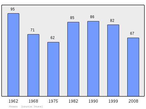
In 2009 the commune had 66 inhabitants. The evolution of the number of inhabitants is known from the population censuses conducted in the commune since 1793. From the 21st century, a census of communes with fewer than 10,000 inhabitants is held every five years, unlike larger towns that have a sample survey every year.[Note 1]
| 1793 | 1800 | 1806 | 1821 | 1831 | 1836 | 1841 | 1846 | 1851 |
|---|---|---|---|---|---|---|---|---|
| 186 | 194 | 180 | 179 | 172 | 179 | 183 | 204 | 215 |
| 1856 | 1861 | 1866 | 1872 | 1876 | 1881 | 1886 | 1891 | 1896 |
|---|---|---|---|---|---|---|---|---|
| 260 | 200 | 181 | 184 | 185 | 154 | 153 | 166 | 141 |
| 1901 | 1906 | 1911 | 1921 | 1926 | 1931 | 1936 | 1946 | 1954 |
|---|---|---|---|---|---|---|---|---|
| 138 | 131 | 122 | 100 | 104 | 86 | 87 | 105 | 120 |
| 1962 | 1968 | 1975 | 1982 | 1990 | 1999 | 2006 | 2009 | - |
|---|---|---|---|---|---|---|---|---|
| 95 | 71 | 62 | 85 | 86 | 82 | 69 | 66 | - |
Religious heritage
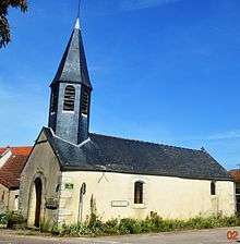
The Parish Church of Saint-Pierre-Célestin contains 2 Monumental Paintings of Saint Ambroise and Saint Nicolas (16th century)![]()
See also
External links
- Arrans on the National Geographic Institute website (in French)
- Arrans on Lion1906
- Arrans on Google Maps
- Arrans on Géoportail, National Geographic Institute (IGN) website (in French)
- Gd. Aran on the 1750 Cassini Map
- Arrans on the INSEE website (in French)
- INSEE (in French)
Notes and references
Notes
- At the beginning of the 21st century, the methods of identification have been modified by Law No. 2002-276 of 27 February 2002 Archived 6 March 2016 at the Wayback Machine, the so-called "law of local democracy" and in particular Title V "census operations" allows, after a transitional period running from 2004 to 2008, the annual publication of the legal population of the different French administrative districts. For communes with a population greater than 10,000 inhabitants, a sample survey is conducted annually, the entire territory of these communes is taken into account at the end of the period of five years. The first "legal population" after 1999 under this new law came into force on 1 January 2009 and was based on the census of 2006.
References
- "Populations légales 2017". INSEE. Retrieved 6 January 2020.
- Google Maps
- List of Mayors of France (in French)
- Ministry of Culture, Palissy IM21008600 2 Monumental Paintings of Saint Ambroise and Saint Nicolas (in French)
| Wikimedia Commons has media related to Arrans. |
| Authority control |
|
|---|