Allerey
Allerey is a commune in the Côte-d'Or department in the Bourgogne-Franche-Comté region of eastern France.
Allerey | |
|---|---|
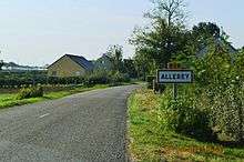
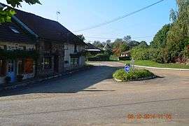 Town square | |
Location of Allerey 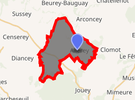
| |
 Allerey  Allerey | |
| Coordinates: 47°11′24″N 4°26′21″E | |
| Country | France |
| Region | Bourgogne-Franche-Comté |
| Department | Côte-d'Or |
| Arrondissement | Beaune |
| Canton | Arnay-le-Duc |
| Intercommunality | Pays d'Arnay |
| Government | |
| • Mayor (2014-2020) | Odette Mazilly |
| Area 1 | 18.99 km2 (7.33 sq mi) |
| Population (2017-01-01)[1] | 170 |
| • Density | 9.0/km2 (23/sq mi) |
| Time zone | UTC+01:00 (CET) |
| • Summer (DST) | UTC+02:00 (CEST) |
| INSEE/Postal code | 21009 /21230 |
| Elevation | 350–528 m (1,148–1,732 ft) |
| 1 French Land Register data, which excludes lakes, ponds, glaciers > 1 km2 (0.386 sq mi or 247 acres) and river estuaries. | |
The inhabitants of the commune are known as Alériens or Alériennes[2]
Geography
Allerey is located some 40 km north-west of Beaune and 30 km north by north-east of Autun. The D906 road passes through the western part of the commune but the village can only be accessed by smaller roads such as the D16 from the south which continues north-east to Arconcey, the D117A from the west which continues south-east to Arnay-le-Duc, and the D36 from Beurey-Bauguay in the north. The commune consists entirely of farmland except for the forested Bois de Come in the south-eastern corner.[3]
The Ruisseau d'Angot rises in the west of the commune and flows south to join the Nailly river.[3]
History
Allerey was the seat of a lordship in the Middle Ages and there was a Fortified house in the centre of the commune.
Administration
List of Successive Mayors[4]
| From | To | Name | Party | Position |
|---|---|---|---|---|
| 2001 | 2014 | Pierre Jarlaud | ||
| 2014 | 2020 | Odette Mazilly |
(Not all data is known)
Demography
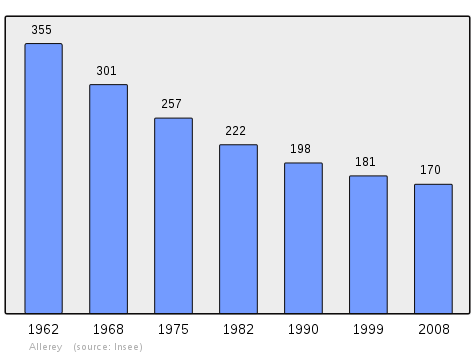
In 2009 the commune had 169 inhabitants. The evolution of the number of inhabitants is known through the population censuses conducted in the commune since 1793. From the 21st century, a census of communes with fewer than 10,000 inhabitants is held every five years, unlike larger towns that have a sample survey every year.[Note 1]
| 1793 | 1800 | 1806 | 1821 | 1831 | 1836 | 1841 | 1846 | 1851 |
|---|---|---|---|---|---|---|---|---|
| 794 | 780 | 827 | 787 | 845 | 770 | 745 | 767 | 752 |
| 1856 | 1861 | 1866 | 1872 | 1876 | 1881 | 1886 | 1891 | 1896 |
|---|---|---|---|---|---|---|---|---|
| 705 | 633 | 705 | 684 | 617 | 598 | 603 | 619 | 599 |
| 1901 | 1906 | 1911 | 1921 | 1926 | 1931 | 1936 | 1946 | 1954 |
|---|---|---|---|---|---|---|---|---|
| 588 | 582 | 522 | 423 | 381 | 383 | 389 | 380 | 345 |
| 1962 | 1968 | 1975 | 1982 | 1990 | 1999 | 2006 | 2009 | - |
|---|---|---|---|---|---|---|---|---|
| 355 | 301 | 257 | 222 | 198 | 181 | 169 | 169 | - |
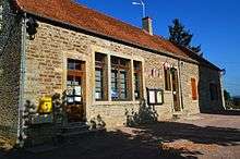
Sites and monuments
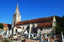
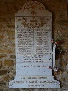
The Church of Saint-Pierre contains two items that are registered as historical objects:
- The Furniture in the Church

- A Stained glass figure (Bay 0) (16th century)
See also
- Communes of the Côte-d'Or department
- French wine
- Cantons of the Côte-d'Or department
- Arrondissements of the Côte-d'Or department
External links
- Allerey on the old National Geographic Institute website (in French)
- Allerey on Lion1906
- Allerey on Google Maps
- Allerey on Géoportail, National Geographic Institute (IGN) website (in French)
- Allerey on the 1750 Cassini Map
- Allerey on the INSEE website (in French)
- INSEE (in French)
Notes and references
Notes
- At the beginning of the 21st century, the methods of identification have been modified by law No. 2002-276 of 27 February 2002 Archived 2016-03-06 at the Wayback Machine, the so-called "law of local democracy" and in particular Title V "census operations" which allow, after a transitional period running from 2004 to 2008, the annual publication of the legal population of the different French administrative districts. For municipalities with a population greater than 10,000 inhabitants, a sample survey is conducted annually, the entire territory of these municipalities is taken into account at the end of the period of five years. The first "legal population" after 1999 under this new law came into force on 1 January 2009 and was based on the census of 2006.
References
- "Populations légales 2017". INSEE. Retrieved 6 January 2020.
- Inhabitants of Côte-d'Or (in French)
- Google Maps
- List of Mayors of France
- Ministry of Culture, Palissy IM21005885 Furniture in the Church (in French)
- Ministry of Culture, Palissy IM21000859 Stained glass figure (Bay 0) (in French)
| Wikimedia Commons has media related to Allerey. |
| Authority control |
|
|---|