Ampilly-le-Sec
Ampilly-le-Sec is a commune in the Côte-d'Or department in the Bourgogne-Franche-Comté region of eastern France.
Ampilly-le-Sec | |
|---|---|
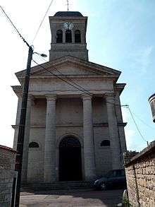
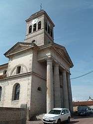 The Village Church | |
.svg.png) Coat of arms | |
Location of Ampilly-le-Sec 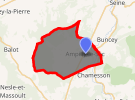
| |
 Ampilly-le-Sec  Ampilly-le-Sec | |
| Coordinates: 47°48′37″N 4°31′54″E | |
| Country | France |
| Region | Bourgogne-Franche-Comté |
| Department | Côte-d'Or |
| Arrondissement | Montbard |
| Canton | Châtillon-sur-Seine |
| Intercommunality | Pays Châtillonnais |
| Government | |
| • Mayor (2014-2020) | René Regnault |
| Area 1 | 24.4 km2 (9.4 sq mi) |
| Population (2017-01-01)[1] | 348 |
| • Density | 14/km2 (37/sq mi) |
| Time zone | UTC+01:00 (CET) |
| • Summer (DST) | UTC+02:00 (CEST) |
| INSEE/Postal code | 21012 /21400 |
| Elevation | 231–314 m (758–1,030 ft) (avg. 285 m or 935 ft) |
| 1 French Land Register data, which excludes lakes, ponds, glaciers > 1 km2 (0.386 sq mi or 247 acres) and river estuaries. | |
The inhabitants of the commune are known as Ampilliaciens or Ampilliaciennes alternatively Ampellois or Ampelloises[2]
Geography
Ampilly-le-Sec is located some 5 km south by south-west of Chatillon-sur-Seine and 15 km east by south-east of Laignes. It can be accessed by the D980 highway from Chatillon-sur-Seine which passes through the village and continues south to Coulmier-le-Sec. The D971 from Buncey to Chamesson also passes through the eastern edge of the commune. From the D971 the D29A goes west through the village then continues to the south-west. The western third of the commune is heavily forested with the rest being entirely farmland.[3]
The Seine River passes through the east of the commune parallel to the D971 flowing from south to north.[3]
Neighbouring communes and villages[3]
Heraldry
Arms of Ampilly-le-Sec |
Blazon: Azure, two stag's heads caboshed of Or posed in pale, in chief argent charged with three millwheels of gules. |
Administration
List of Successive Mayors[4]
| From | To | Name | Party | Position |
|---|---|---|---|---|
| 2001 | 2020 | René Regnault |
(Not all data is known)
Demography
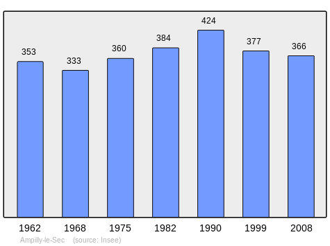
In 2009 the commune had 362 inhabitants. The evolution of the number of inhabitants is known through the population censuses conducted in the commune since 1793. From the 21st century, a census of communes with fewer than 10,000 inhabitants is held every five years, unlike larger towns that have a sample survey every year.[Note 1]
| 1793 | 1800 | 1806 | 1821 | 1831 | 1836 | 1841 | 1846 | 1851 |
|---|---|---|---|---|---|---|---|---|
| 476 | 517 | 536 | 536 | 525 | 645 | 664 | 603 | 590 |
| 1856 | 1861 | 1866 | 1872 | 1876 | 1881 | 1886 | 1891 | 1896 |
|---|---|---|---|---|---|---|---|---|
| 626 | 548 | 605 | 577 | 553 | 570 | 560 | 505 | 449 |
| 1901 | 1906 | 1911 | 1921 | 1926 | 1931 | 1936 | 1946 | 1954 |
|---|---|---|---|---|---|---|---|---|
| 468 | 416 | 416 | 365 | 337 | 413 | 372 | 356 | 386 |
| 1962 | 1968 | 1975 | 1982 | 1990 | 1999 | 2006 | 2009 | - |
|---|---|---|---|---|---|---|---|---|
| 353 | 333 | 360 | 384 | 424 | 377 | - | 362 | - |
Culture and heritage
Civil heritage
The commune has a number of buildings and structures that are registered as historical monuments:
Religious heritage
The commune has several religious buildings and sites that are registered as historical monuments:
- A Wayside Cross at CR 12 (18th century)

- A Tomb at CR 25 (19th century)
- A Cemetery Cross at CR 25 (19th century)
- A Cemetery Chapel at CR 25 (19th century)
- A Wayside Cross at CR 8 (18th century)
- A Wayside Cross at CVO2 and CR32 crossroads (1840)
- A Wayside Cross at Rue de Chamesson and CR13 crossroads (1811)
- A Cemetery at Rue de l'Église (19th century)
- The Parish Church of Saint Peter and Paul at Rue de l'Église (1827).
- A Wayside Cross at RD 29a (1877)
- A Wayside Cross at RD29a and CR 25 crossroads (1762)
- A Wayside Cross at RN 71 and former Chemin de Chamesson crossroads at Vanvey (1861)
- A Wayside Cross at Grande Rue and Rue de la Croix de Mission crossroads (19th century)
- A Monumental Cross (1638)
- A Wayside Cross at Ferme de la Forêt (1783)
- A Wayside Cross at Ferme de la Forfol (18th century)
See also
External links
- Ampilly-le-Sec on the National Geographic Institute website (in French)
- Ampilly-le-Sec on Lion1906
- Ampilly-le-Sec on Google Maps
- Ampilly-le-Sec on Géoportail, National Geographic Institute (IGN) website (in French)
- Ampilly on the 1750 Cassini Map
- Ampilly-le-Sec on the INSEE website (in French)
- INSEE (in French)
Notes and references
Notes
- At the beginning of the 21st century, the methods of identification have been modified by law No. 2002-276 of 27 February 2002 Archived 2016-03-06 at the Wayback Machine, the so-called "law of local democracy" and in particular Title V "census operations" which allow, after a transitional period running from 2004 to 2008, the annual publication of the legal population of the different French administrative districts. For communes with a population greater than 10,000 inhabitants, a sample survey is conducted annually, the entire territory of these communes is taken into account at the end of the period of five years. The first "legal population" after 1999 under this new law came into force on 1 January 2009 and was based on the census of 2006.
References
- "Populations légales 2017". INSEE. Retrieved 6 January 2020.
- Inhabitants of Côte-d'Or (in French)
- Google Maps
- List of Mayors of France
- Ministry of Culture, Mérimée IA00096367 Blast Furnace (in French)
- Ministry of Culture, Mérimée IA00096318 House at Rue de Coulmier (in French)
- Ministry of Culture, Mérimée IA00096317 House at Rue de la Maison Commune (in French)
- Ministry of Culture, Mérimée IA00096244 Town Hall/School at Rue de la Maison Commune (in French)
- Ministry of Culture, Mérimée PA00112057 Ironworks (in French)
- Ministry of Culture, Mérimée IA00096316 Houses (in French)
- Ministry of Culture, Mérimée IA00096248 Wayside Cross at CR 12 (in French)
- Ministry of Culture, Mérimée IA00096258 Tomb at CR 25 (in French)
- Ministry of Culture, Mérimée IA00096256 Cemetery Cross at CR 25 (in French)
- Ministry of Culture, Mérimée IA00096243 Cemetery Chapel at CR 25 (in French)
- Ministry of Culture, Mérimée IA00096250 Wayside Cross at CR 8 (in French)
- Ministry of Culture, Mérimée IA00096252 Wayside Cross at CVO2 and CR32 crossroads (in French)
- Ministry of Culture, Mérimée IA00096253 Wayside Cross at Rue de Chamesson and CR13 crossroads (in French)
- Ministry of Culture, Mérimée IA00096257 Cemetery at Rue de l'Église (in French)
- Ministry of Culture, Mérimée IA00096242 Parish Church of Saint Peter and Paul at Rue de l'Église (in French)
- Ministry of Culture, Mérimée IA00096246 Wayside Cross at RD 29a (in French)
- Ministry of Culture, Mérimée IA00096247 Wayside Cross at RD 29a and CR 25 crossroads (in French)
- Ministry of Culture, Mérimée IA00096245 Wayside Cross at RN 71 and former Chemin de Chamesson crossroads at Vanvey (in French)
- Ministry of Culture, Mérimée IA00096254 Wayside Cross at Grande Rue and Rue de la Croix de Mission crossroads (in French)
- Ministry of Culture, Mérimée IA00096255 Monumental Cross (in French)
- Ministry of Culture, Mérimée IA00096251 Wayside Cross at Ferme de la Forêt (in French)
- Ministry of Culture, Mérimée IA00096249 Wayside Cross at Ferme de la Forfol (in French)
| Wikimedia Commons has media related to Ampilly-le-Sec. |
| Authority control |
|
|---|