Baulme-la-Roche
Baulme-la-Roche is a commune in the Côte-d'Or department in the Bourgogne-Franche-Comté region of eastern France.[2]
Baulme-la-Roche | |
|---|---|
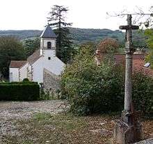
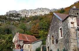 A general view of Baulme-la-Roche | |
.svg.png) Coat of arms | |
Location of Baulme-la-Roche 
| |
 Baulme-la-Roche  Baulme-la-Roche | |
| Coordinates: 47°20′48″N 4°47′59″E | |
| Country | France |
| Region | Bourgogne-Franche-Comté |
| Department | Côte-d'Or |
| Arrondissement | Dijon |
| Canton | Talant |
| Intercommunality | Sombernonnais |
| Government | |
| • Mayor (2008–2014) | Gisèle Monot |
| Area 1 | 6.69 km2 (2.58 sq mi) |
| Population (2017-01-01)[1] | 90 |
| • Density | 13/km2 (35/sq mi) |
| Time zone | UTC+01:00 (CET) |
| • Summer (DST) | UTC+02:00 (CEST) |
| INSEE/Postal code | 21051 /21410 |
| Elevation | 360–596 m (1,181–1,955 ft) (avg. 450 m or 1,480 ft) |
| 1 French Land Register data, which excludes lakes, ponds, glaciers > 1 km2 (0.386 sq mi or 247 acres) and river estuaries. | |
The inhabitants of the commune are known as Rochebalmiens or Rochebalmiennes.[3]
Geography
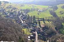
Baulme-la-Roche is located some 17 km west by north-west of Dijon and 8 km north-east of Sombernon. Access to the commune is by the D104C from Mâlain in the south which passes through the commune and the village and continues north-east to join the D10 south-east of Panges. The Paris–Marseille railway passes through the commune and the entrance to the Blaisy-Bas Tunnel is in the commune. The nearest station is at Malain south of the commune. The commune is mostly farmland but there are extensive forests - especially in the east.[4][5]
The Douix river rises in the west of the commune and flows south-east to join the Ouche east of Sainte-Marie-sur-Ouche. The Ruisseau de Baulme-la-Roche rises in the centre of the commune and flows south-west to join the Douix.[4][5]
Neighbouring communes and villages[4] | ||||||||||
|---|---|---|---|---|---|---|---|---|---|---|
| ||||||||||
Toponymy
Baulme-la-Roche appears as Beaume la Roche on the 1750 Cassini Map[6] and the same on the 1790 version.[7]
Heraldry
Arms of Baulme-la-Roche |
Blazon: Party per fess, at 1 party per pale, Argent a cross Gules charged with 5 roses and Azure a dexter arm carnation vested Argent holds a crozier of Or; at 2 Azure, a mountain of 3 hillocks of Or; all debruised by a barrulet on the division charged with a fess wavy of Azure. |
Administration
| From | To | Name | Party | Position |
|---|---|---|---|---|
| 2001 | 2011 | Gisèle Monot | ||
| 2011 | 2014 | Jean Luc Gourdin | ||
| 2014 | 2020 | Raphaël Vejux |
(Not all data is known)
Demography
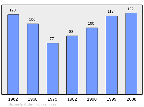
In 2010 the commune had 113 inhabitants. The evolution of the number of inhabitants is known from the population censuses conducted in the commune since 1793. From the 21st century, a census of communes with fewer than 10,000 inhabitants is held every five years, unlike larger communes that have a sample survey every year.[Note 1]
| 1793 | 1800 | 1806 | 1821 | 1831 | 1836 | 1841 | 1846 | 1851 |
|---|---|---|---|---|---|---|---|---|
| 357 | 329 | 335 | 314 | 300 | 284 | 249 | 393 | 392 |
| 1856 | 1861 | 1866 | 1872 | 1876 | 1881 | 1886 | 1891 | 1896 |
|---|---|---|---|---|---|---|---|---|
| 244 | 239 | 222 | 198 | 238 | 234 | 214 | 211 | 195 |
| 1901 | 1906 | 1911 | 1921 | 1926 | 1931 | 1936 | 1946 | 1954 |
|---|---|---|---|---|---|---|---|---|
| 177 | 186 | 184 | 150 | 170 | 168 | 156 | 139 | 130 |
| 1962 | 1968 | 1975 | 1982 | 1990 | 1999 | 2006 | 2010 | - |
|---|---|---|---|---|---|---|---|---|
| 120 | 106 | 77 | 88 | 100 | 118 | 121 | 113 | - |
Culture and heritage
Civil heritage
The commune has a number of buildings and sites that are registered as historical monuments:
Religious heritage
The commune has several religious buildings and sites that are registered as historical monuments:
- A Benedictine Priory (1502)

- The Parish Church of Saint Martin (15th century)
The Church contains a large number of items that are registered as historical objects. For a complete list including links to descriptions (in French) click here.
See also
Notes and references
Notes
- At the beginning of the 21st century, the methods of identification have been modified by Law No. 2002-276 of 27 February 2002, the so-called "law of local democracy" and in particular Title V "census operations" allows, after a transitional period running from 2004 to 2008, the annual publication of the legal population of the different French administrative districts. For communes with a population greater than 10,000 inhabitants, a sample survey is conducted annually and the entire territory of these communes is taken into account at the end of the period of five years. The first "legal population" after 1999 under this new law came into force on 1 January 2009 and was based on the census of 2006.
References
- "Populations légales 2017". INSEE. Retrieved 6 January 2020.
- Baulme-la-Roche on Lion1906
- Inhabitants of Côte-d'Or (in French)
- Baulme-la-Roche on Google Maps
- Baulme-la-Roche on the Géoportail from National Geographic Institute (IGN) website (in French)
- Beaume la Roche on the 1750 Cassini Map
- Beaume la Roche on the 1790 Cassini Map
- List of Mayors of France (in French)
- Ministry of Culture, Mérimée IA00059737 Farmhouse (in French)
- Ministry of Culture, Mérimée IA00059736 House (in French)
- Ministry of Culture, Mérimée IA00059859 Farmhouse (in French)
- Ministry of Culture, Mérimée IA00059740 House (in French)
- Ministry of Culture, Mérimée IA00059742 Blacksmith's House (in French)
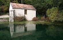
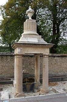
- Ministry of Culture, Mérimée PA00112097 Fountain (in French)
- Ministry of Culture, Mérimée IA00059858 Houses and farms (in French)
- Ministry of Culture, Mérimée IA00059782 Fountain (in French)
- Ministry of Culture, Mérimée IA00059782 PA21000008 Benedictine Priory

- Ministry of Culture, Mérimée IA00059738 IA00059739 Parish Church of Saint Martin (in French)
| Wikimedia Commons has media related to Baulme-la-Roche. |
| Authority control |
|
|---|