Rozstání (Prostějov District)
Rozstání is a village and municipality (obec) in Prostějov District in the Olomouc Region of the Czech Republic.
Rozstání | |
|---|---|
Municipality | |
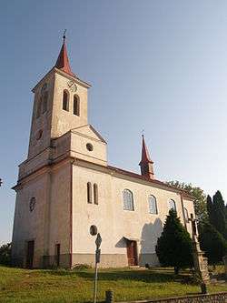 Church of Saint Michael | |
 Rozstání | |
| Coordinates: 49°23′58″N 16°50′57″E | |
| Country | |
| Region | Olomouc |
| District | Prostějov |
| Area | |
| • Total | 16.56 km2 (6.39 sq mi) |
| Elevation | 545 m (1,788 ft) |
| Population (2006) | |
| • Total | 662 |
| • Density | 40/km2 (100/sq mi) |
| Postal code | 798 61 to 798 62 |
| Website | http://www.rozstani.eu/ |
The municipality covers an area of 16.56 square kilometres (6.39 sq mi), and has a population of 662 (as at 28 August 2006).
Rozstání lies approximately 21 kilometres (13 mi) south-west of Prostějov, 37 km (23 mi) south-west of Olomouc, and 191 km (119 mi) south-east of Prague.
This article is issued from Wikipedia. The text is licensed under Creative Commons - Attribution - Sharealike. Additional terms may apply for the media files.