Horní Štěpánov
Horní Štěpánov (German: Stefansdorf) is a village and municipality (obec) in Prostějov District in the Olomouc Region of the Czech Republic.
Horní Štěpánov | |
|---|---|
Municipality | |
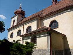 Church of Saint Lawrence | |
 Flag  Coat of arms | |
 Horní Štěpánov | |
| Coordinates: 49°32′52″N 16°47′18″E | |
| Country | |
| Region | Olomouc |
| District | Prostějov |
| Area | |
| • Total | 20 km2 (8 sq mi) |
| Elevation | 605 m (1,985 ft) |
| Population (2019)[1] | |
| • Total | 893 |
| • Density | 45/km2 (120/sq mi) |
| Postal code | 798 47 |
| Website | http://www.hornistepanov.cz |
The municipality covers an area of 20 square kilometres (7.7 sq mi), and has a population of 893 (2019).
Horní Štěpánov lies approximately 25 kilometres (16 mi) west of Prostějov, 34 km (21 mi) west of Olomouc, and 181 km (112 mi) east of Prague.
References
| Wikimedia Commons has media related to Horní Štěpánov. |
- "Population of municipalities of the Czech Republic". Czech Statistical Office. 1 January 2019.
This article is issued from Wikipedia. The text is licensed under Creative Commons - Attribution - Sharealike. Additional terms may apply for the media files.