Bedihošť
Bedihošť Czech pronunciation: [ˈbɛɟɪɦoʃc] is a village and municipality (obec) in Prostějov District in the Olomouc Region of the Czech Republic.
Bedihošť | |
|---|---|
Municipality | |
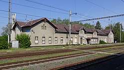 Railway station | |
 Flag  Coat of arms | |
 Bedihošť | |
| Coordinates: 49°26′53″N 17°9′59″E | |
| Country | |
| Region | Olomouc |
| District | Prostějov |
| Area | |
| • Total | 6.46 km2 (2.49 sq mi) |
| Elevation | 209 m (686 ft) |
| Population (2007) | |
| • Total | 1,031 |
| • Density | 160/km2 (410/sq mi) |
| Postal code | 798 21 |
| Website | http://www.bedihost.estranky.cz |
The municipality covers an area of 6.46 square kilometres (2.49 sq mi), and has a population of 1,031 (as at 31 December 2007).
Bedihošť lies approximately 5 kilometres (3 mi) south-east of Prostějov, 18 km (11 mi) south of Olomouc, and 210 km (130 mi) east of Prague. Its first historical reference is from the year 1275.
Bedihošť borders upon Prostějov, Kralice na Hané, Hrubčice, Otonovice and Čehovice.
The streets of Bedihošť: B. Němcové, Husova, Jiráskova, Komendova, Komenského, L. Svobody, Lidická, Nerudova, Osvobození, Palackého, Prostějovská, Tovární, U Parku, Za sokolovnou, Zátiší. (There are registered 15 streets and 332 address points.)
Sights and unique objects:
The Chapel of Saint Wenceslaus, the Chapel of Saint Florian, The Sundial.