Doloplazy (Prostějov District)
Doloplazy is a village and municipality (obec) in Prostějov District in the Olomouc Region of the Czech Republic.
Doloplazy | |
|---|---|
Municipality | |
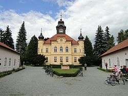 Doloplazy Chateau | |
 Flag  Coat of arms | |
 Doloplazy | |
| Coordinates: 49°20′55″N 17°8′57″E | |
| Country | |
| Region | Olomouc |
| District | Prostějov |
| Area | |
| • Total | 2.91 km2 (1.12 sq mi) |
| Elevation | 214 m (702 ft) |
| Population (2006) | |
| • Total | 571 |
| • Density | 200/km2 (510/sq mi) |
| Postal code | 798 26 |
| Website | http://www.obecdoloplazy.cz |
The municipality covers an area of 2.91 square kilometres (1.12 sq mi), and has a population of 571 (as at 28 August 2006).
Doloplazy lies approximately 14 kilometres (9 mi) south of Prostějov, 29 km (18 mi) south of Olomouc, and 213 km (132 mi) south-east of Prague.
This article is issued from Wikipedia. The text is licensed under Creative Commons - Attribution - Sharealike. Additional terms may apply for the media files.